Gloria, Oriental Mindoro
Gloria, officially the Municipality of Gloria (Tagalog: Bayan ng Gloria), is a 3rd class municipality in the province of Oriental Mindoro, Philippines. According to the 2015 census, it has a population of 45,073 people. [3]
Gloria | |
|---|---|
| Municipality of Gloria | |
 Seal | |
| Nickname(s): Agricultural Production and Eco-Tourism Center of Oriental Mindoro | |
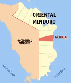 Map of Oriental Mindoro with Gloria highlighted | |
OpenStreetMap 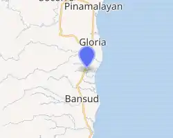
| |
.svg.png.webp) Gloria Location within the Philippines | |
| Coordinates: 12°55′N 121°28′E | |
| Country | |
| Region | Mimaropa (Region IV-B) |
| Province | Oriental Mindoro |
| District | 2nd District |
| Founded | October 1, 1964 |
| Named for | Gloria Macapagal Arroyo |
| Barangays | 27 (see Barangays) |
| Government | |
| • Type | Sangguniang Bayan |
| • Mayor | German D. Rodegerio |
| • Vice Mayor | Vic Ruskin M. Ong |
| • Representative | Alfonso V. Umali Jr. |
| • Electorate | 30,698 voters (2019) |
| Area | |
| • Total | 245.52 km2 (94.80 sq mi) |
| Elevation | 15 m (49 ft) |
| Population | |
| • Total | 45,073 |
| • Density | 180/km2 (480/sq mi) |
| • Households | 10,314 |
| Economy | |
| • Income class | 3rd municipal income class |
| • Poverty incidence | 16.92% (2015)[4] |
| • Revenue | ₱119,295,677.05 (2016) |
| Time zone | UTC+8 (PST) |
| ZIP code | 5209 |
| PSGC | |
| IDD : area code | +63 (0)43 |
| Climate type | tropical climate |
| Native languages | Tawbuid language Tagalog |
| Website | www |
The town was previously a barangay called Maligaya, the largest barangay during the administration of President Diosdado Macapagal. Local politicians, led by former guerrilla chief Nicolas Jamilla, Sr., battled for the conversion of Maligaya into a new town. They renamed it after the ten-year-old daughter of the President, Gloria Macapagal Arroyo, who later on herself became the fourteenth President in 2001. Jamilla became the first mayor of the town, which kept the old name "Maligaya" as the name of a barangay in the poblacion.
Geography
Gloria is located 77 kilometres (48 mi) from the provincial capital Calapan City.
It is one of the 7 towns comprising Oriental Mindoro's second district. On its north lies its mother town Pinamalayan, on the west is the town of Sablayan in Occidental Mindoro. On the south is the town of Bansud, while on the east is the Tablas Strait.
Climate
| Climate data for Gloria, Oriental Mindoro | |||||||||||||
|---|---|---|---|---|---|---|---|---|---|---|---|---|---|
| Month | Jan | Feb | Mar | Apr | May | Jun | Jul | Aug | Sep | Oct | Nov | Dec | Year |
| Average high °C (°F) | 26 (79) |
28 (82) |
29 (84) |
31 (88) |
31 (88) |
30 (86) |
29 (84) |
29 (84) |
29 (84) |
29 (84) |
28 (82) |
27 (81) |
29 (84) |
| Average low °C (°F) | 22 (72) |
22 (72) |
22 (72) |
23 (73) |
25 (77) |
25 (77) |
25 (77) |
25 (77) |
25 (77) |
24 (75) |
23 (73) |
23 (73) |
24 (75) |
| Average precipitation mm (inches) | 115 (4.5) |
66 (2.6) |
55 (2.2) |
39 (1.5) |
164 (6.5) |
282 (11.1) |
326 (12.8) |
317 (12.5) |
318 (12.5) |
192 (7.6) |
119 (4.7) |
173 (6.8) |
2,166 (85.3) |
| Average rainy days | 13.6 | 9.4 | 10.4 | 10.5 | 21.1 | 26.0 | 29.0 | 27.6 | 27.5 | 23.1 | 16.7 | 16.1 | 231 |
| Source: Meteoblue [5] | |||||||||||||
Barangays
Gloria is divided into 27 barangays: nine (9) barangays are situated along the national highway - Bulaklakan, Maligaya, Kawit, Narra, Balete, Lucio Laurel, G. Antonino, Santa Maria and Banus; six (6) are coastal barangays - Tambong, San Antonio, Santa Theresa, Guimbonan, Maragooc and Agsalin; and twelve (12) interior barangays on the west side - Agos, A. Bonifacio, Alma Villa, Mirayan, Buong Lupa, Malamig, Malubay, M. Adriatico, Papandungin, Malayong, Banutan and Manguyang.[6]
| Barangay | Population (2016) |
|---|---|
| Agsalin | 678 |
| Agos | 1,036 |
| Alma Villa | 1,411 |
| Andres Bonifacio | 1,320 |
| Balete | 2,864 |
| Banus | 2,298 |
| Banutan | 906 |
| Buong Lupa | 969 |
| Bulaklakan | 1,126 |
| Gaudencio Antonino (Tinalunan) | 1,651 |
| Guimbonan | 1,104 |
| Kawit | 2,022 |
| Lucio Laurel (Calamundingan) | 2,649 |
| Macario Adriatico (Tubag) | 1,139 |
| Malamig | 2,929 |
| Malayong | 1,228 |
| Maligaya (Poblacion) | 3,246 |
| Malubay | 1,319 |
| Manguyang | 1,633 |
| Maragooc | 1,258 |
| Mirayan | 938 |
| Narra (Malusak) | 2,169 |
| Papandungin | 1,110 |
| San Antonio (Dalagan) | 1,330 |
| Santa Maria (Bulbugan) | 2,034 |
| Santa Theresa (Langgang) | 1,523 |
| Tambong | 3,183 |
| Total | 45,073 |
History
Gloria was once part of the municipality of Pinamalayan. In 1915, migrant families from Marinduque settled in Barrio Tambong, and in 1930, when a national road was built through Pinamalayan, they moved west and occupied the area along this road. Tambong was later divided into two barrios: the first retained the original name, while the second was called Maligaya (meaning "happy"), alluding to the settlers' happiness at the bountiful yield of their agricultural crops.[7]
The residents of 25 barrios (Maligaya, Kawit, Malusak, Balite, Dalagan, Tinalunan, Calamundingan, Bulbogan, Langang, Banus, Agus, Batingan, Papandungin, Malamig, Tubag, Malayong, Malubay, Mirayan, Guimbonan, Agsalin, Manguyang, Banutan, Boong-Lupa, Tambong and Maragooc) grouped together and petitioned for the separation of their barrios from the municipality of Pinamalayan. The petition was granted on October 1, 1964, through Executive Order No. 117 issued by President Diosdado Macapagal. Executive Order No. 140, issued on February 25, 1965, by the same President, defined and fixed the boundaries of Gloria as a new municipality. On December 24, 1965, however, the Supreme Court nullified its status as a municipality. Gloria was finally recognized as a distinct municipality on June 9, 1966, when Housebill No. 6107, sponsored by Congressman Luciano Joson, was enacted into law. (It later became known as RA 4651.)[7]
The new municipality was named Gloria, primarily as a token of gratitude to President Macapagal, whose daughter is named Gloria, and secondarily from the word "glory", celebrating the settlers' "glorious" life in Barrio Maligaya.
Barrio Maligaya later became the poblacion and the official seat of the municipal government. Nicolas M. Jamilla Sr. was appointed first Mayor of Gloria by President Diosdado Macapagal, serving from 1964 to 1967. He then ran in the local election of 1967 and won. The first session of the Municipal Council was held in the residence of Mr. Albino Janda. The town's official functions were held in this house from February 1964 to November 1965; then in the residences of Genaro Olavidez from March to June 1965 and Arsenio Arriola from July 1965 to 1973.[7]
The name of the following barangays were changed: Bulbugan to Santa Maria; Dalagan to San Antonio; Malusak to Narra; Batingan to A. Bonifacio; Tubag to Macario Adriatico; Tinalunan to Gaudencio Antonino; Langang to Santa Theresa and Calamundingan to Lucio Laurel. The new barangays of Bulaklakan and Alma Villa were created later. In 1968, Gloria Realty Development Corporation donated two hectares to the municipality, and this became the site of the Municipal Building in 1972. Under the leadership of Mayor Jamilla, the municipality later bought a ten-hectare lot, which became the site of the Municipal Cemetery, Sports Center, Agricultural Center and Breeding Station, and the Medicare Hospital.[7]
Demographics
|
| |||||||||||||||||||||||||||||||||
| Source: Philippine Statistics Authority [3] [8] [9][10] | ||||||||||||||||||||||||||||||||||
Local government
Current Municipal Officials:
| Officials | Political Party |
|---|---|
| Rodegerio, Bitoy
(Mayor) |
LP |
| Solas, Ramon
(Vice Mayor) |
LP |
| Councilors | Political Party |
| Bawasanta, Crispin | UNA |
| Jamilla, Nick Orlando | LP |
| Paz, Norma | UNA |
| Alvarez, Rambo | NPC |
| Fabon, Jun | NPC |
| Sadiwa, Romeo | LP |
List of former mayors
- Nicolas M. Jamilla, Sr. (1964–1986; 1988–1995)+
- Amando Medrano (1986–1987)+
- Felix V. Jarabe (1987)+
- Alonzo San Agustin (1987–1988)+
- Jimmy S. de Castro (1995–2001)
- Romeo D. Alvarez (2001–2010)
- Loreto S. Pérez (2
Events
- February 14–15: Town Fiesta in honor fn the Sacred Heart of Jesus
- September 29 to October 1: Kawayanan Festival
- October 1: Foundation Day
Education
Tertiary
- Erhard Science and Technological Institute
- Gloria Institute of Science and Technology
Secondary
- President Diosdado Macapagal Memorial National High School (formerly known as Malamig National High School Extension)
- Malamig National High School
- Manuel Adriano Memorial National High School
- Bulbugan National High School
- Sacred Heart Academy
- Oriental Mindoro Institute
- CLJC Center for Excellence and Development Academy
References
- Municipality of Gloria | (DILG)
- "Province: Oriental Mindoro". PSGC Interactive. Quezon City, Philippines: Philippine Statistics Authority. Retrieved 12 November 2016.
- Census of Population (2015). "Region IV-B (Mimaropa)". Total Population by Province, City, Municipality and Barangay. PSA. Retrieved 20 June 2016.
- "PSA releases the 2015 Municipal and City Level Poverty Estimates". Quezon City, Philippines. Retrieved 12 October 2019.
- "Gloria: Average Temperatures and Rainfall". Meteoblue. Retrieved 27 April 2020.
- "Brief Introduction about the Municipality of Gloria". Municipality of Gloria. Archived from the original on 11 November 2012. Retrieved 30 October 2012.
- "History and Roll of Honors". Profile :: About the Municipality. Municipality of Gloria. 30 September 2010. Archived from the original on 11 November 2012. Retrieved 30 October 2012.
- Census of Population and Housing (2010). "Region IV-B (Mimaropa)". Total Population by Province, City, Municipality and Barangay. NSO. Retrieved 29 June 2016.
- Censuses of Population (1903–2007). "Region IV-B (Mimaropa)". Table 1. Population Enumerated in Various Censuses by Province/Highly Urbanized City: 1903 to 2007. NSO.
- "Province of Oriental Mindoro". Municipality Population Data. Local Water Utilities Administration Research Division. Retrieved 17 December 2016.
External links
- Gloria Profile at PhilAtlas.com
- Philippine Standard Geographic Code
- Philippine Census Information
- Local Governance Performance Management System
- Official website
Places adjacent to Gloria, Oriental Mindoro | |
|---|---|