Gmina Frysztak
Gmina Frysztak is a rural gmina (administrative district) in Strzyżów County, Subcarpathian Voivodeship, in south-eastern Poland. Its seat is the village of Frysztak, which lies approximately 14 kilometres (9 mi) south-west of Strzyżów and 36 km (22 mi) south-west of the regional capital Rzeszów.
Gmina Frysztak
Frysztak Commune | |
|---|---|
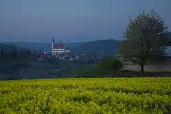 View of Frystak | |
 Flag  Coat of arms | |
| Coordinates (Frysztak): 49°50′N 21°37′E | |
| Country | |
| Voivodeship | Subcarpathian |
| County | Strzyżów |
| Seat | Frysztak |
| Area | |
| • Total | 90.51 km2 (34.95 sq mi) |
| Population (2006) | |
| • Total | 10,635 |
| • Density | 120/km2 (300/sq mi) |
| Website | http://www.frysztak.pl |
The gmina covers an area of 90.51 square kilometres (34.9 sq mi), and as of 2006 its total population is 10,635.
The gmina contains part of the protected area called Czarnorzeki-Strzyżów Landscape Park.
Villages
Gmina Frysztak contains the villages and settlements of Chytrówka, Cieszyna, Frysztak, Glinik Dolny, Glinik Górny, Glinik Średni, Gogołów, Huta Gogołowska, Kobyle, Lubla, Pułanki, Stępina, Twierdza and Widacz.
Neighbouring gminas
Gmina Frysztak is bordered by the gminas of Brzostek, Jasło, Kołaczyce, Wielopole Skrzyńskie, Wiśniowa and Wojaszówka.
References
| Seat | | |
|---|---|---|
| Other villages | ||
| Seat |  | |
|---|---|---|
| Urban-rural gmina | ||
| Rural gminas | ||