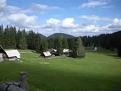
Goreljek
Goreljek (pronounced [ɡɔˈɾeːljək] or [ɡɔˈɾeːljɛk]) is a high-elevation settlement on the Pokljuka Plateau in the Municipality of Bohinj in the Upper Carniola region of Slovenia. It has less than ten residents, but there are a large number of holiday homes in Goreljek and its immediate area. The northern part of the settlement's territory extends into the Ore Valley (Slovene: Rudna dolina). The local chapel is dedicated to Saint Anthony the Hermit and was rebuilt in a modern alpine style in 1996.[2]
Goreljek | |
|---|---|
 | |
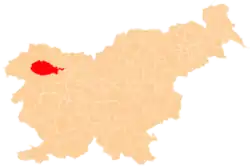
 Goreljek Location in Slovenia | |
| Coordinates: 46°19′55.57″N 13°58′29.3″E | |
| Country | |
| Traditional region | Upper Carniola |
| Statistical region | Upper Carniola |
| Municipality | Bohinj |
| Area | |
| • Total | 13.5 km2 (5.2 sq mi) |
| Elevation | 1,257.9 m (4,127.0 ft) |
| Population (2015) | |
| • Total | 7 |
| • Density | 1/km2 (3/sq mi) |
| [1] | |
History
Goreljek was first attested in written sources as Gorellegk in 1494,[3][4] and it was originally a mountain pasture belonging to the village of Koprivnik v Bohinju.[4][5] During the Second World War, German forces surrounded and destroyed most of the 3rd Battalion of the Partisans' Prešeren Brigade at Goreljek on December 15, 1943.[6]
References
- Statistical Office of the Republic of Slovenia
- Slovenia tourist organisation site
- Žiga Zwitter (2013). "Krčenje in agrarna raba gozdov na Gorenjskem v času višinske kolonizacije". In Rogelj, Boštjan; Potočnik Slavič, Irma; Mrak, Irena (eds.). Gorenjska v obdobju glokalizacije. Ljubljana: Znanstvena založba Filozofske fakultete Univerze v Ljubljani. p. 92.
- Melik, Anton (1950). Planine v Julijskih alpah. Ljubljana: Slovenska akademija znanosti in umetnosti. pp. 79, 90.
- Krajevni leksikon Dravske Banovine. Ljubljana: Zveza za tujski promet za Slovenijo. 1937. p. 533.
- Križnar, Ivan (1995). "Pokljuka". Enciklopedija Slovenije. 9. Ljubljana: Mladinska knjiga. pp. 50–51.
External links
- Goreljek at Geopedia
 Media related to Goreljek at Wikimedia Commons
| Settlements | Administrative centre: Bohinjska Bistrica
|  Location of the Municipality of Bohinj in Slovenia | ||||
|---|---|---|---|---|---|---|
| Landmarks |
| |||||
