Grabki Duże
Grabki Duże[2][3][4] [ˈɡrapki ˈduʐɛ] is a village in the administrative district of Gmina Szydłów, within Staszów County, Świętokrzyskie Voivodeship, in south-central Poland. It lies approximately 4 kilometres (2 mi) west of Szydłów, 16 km (10 mi) west of Staszów, and 41 km (25 mi) south-east of the regional capital Kielce.[5]
Grabki Duże | |
|---|---|
Village | |
 Grabki Duże | |
| Coordinates: 50°35′12″N 20°57′12″E | |
| Country | |
| Voivodeship | Świętokrzyskie |
| County | Staszów |
| Gmina | Szydłów |
| Sołectwo | Grabki Duże |
| Elevation | 235.2 m (771.7 ft) |
| Population (31 December 2009 at Census)[1] | |
| • Total | |
| Time zone | UTC+1 (CET) |
| • Summer (DST) | UTC+2 (CEST) |
| Postal code | 28-225 |
| Area code(s) | +48 41 |
| Car plates | TSZ |
The village has a population of ![]() 375.
375.
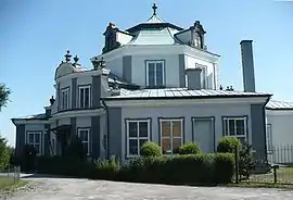
In a village there is a baroque palace from 1742, designed in oriental style by Franciszek Placidi. It was built by a noble Stanisław Rupniewski, who spent some time in a Turkish captivity and converted himself to Islam. The palace was nicknamed "harem" by the neighbors. The palace is in private hands and can be viewed from the outside.
Demography
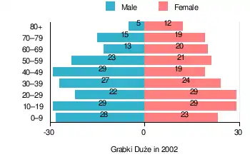
According to the 2002 Poland census, there were 387 people residing in Grabki Duże village, of whom 49.4% were male and 50.6% were female. In the village, the population was spread out, with 25.1% under the age of 18, 36.2% from 18 to 44, 19.4% from 45 to 64, and 19.4% who were 65 years of age or older.[1]
Table 1. Population level of village in 2002 – by age group[1] SPECIFICATION Measure
unitPOPULATION
(by age group in 2002)TOTAL 0–9 10–19 20–29 30–39 40–49 50–59 60–69 70–79 80 + I. TOTAL person 387 51 58 51 51 48 44 33 34 17 — of which in % 100 13.2 15 13.2 13.2 12.4 11.4 8.5 8.8 4.4 1. BY SEX A. Males person 191 28 29 22 27 29 23 13 15 5 — of which in % 49.4 7.2 7.5 5.7 7 7.5 5.9 3.4 3.9 1.3 B. Females person 196 23 29 29 24 19 21 20 19 12 — of which in % 50.6 5.9 7.5 7.5 6.2 4.9 5.4 5.2 4.9 3.1
Figure 1. Population pyramid of village in 2002 – by age group and sex[1]
Table 2. Population level of village in 2002 – by sex[1] SPECIFICATION Measure
unitPOPULATION
(by sex in 2002)TOTAL Males Females I. TOTAL person 387 191 196 — of which in % 100 49.4 50.6 1. BY AGE GROUP A. At pre-working age person 97 53 44 — of which in % 25.1 13.7 11.4 B. At working age. grand total person 215 114 101 — of which in % 55.6 29.5 26.1 a. at mobile working age person 140 71 69 — of which in | % 36.2 18.4 17.8 b. at non-mobile working age person 75 43 32 — of which in | % 19.4 11.1 8.3 C. At post-working age person 75 24 51 — of which in % 19.4 6.2 13.2
References
- "Local Data Bank (Bank Danych Lokalnych) – Layout by NTS nomenclature (Układ wg klasyfikacji NTS)". demografia.stat.gov.pl: GUS. 10 March 2011.
- Bielec, Jan (ed.); Szwałek, Stanisława (1980). Wykaz urzędowych nazw miejscowości w Polsce. T. I: A – J [List of official names of localities in Poland, Vol. I: A – J] (in Polish). Ministry of Administration, Spatial Economy and Environmental Protection (1st ed.). Warsaw, Poland: Central Statistical Office.CS1 maint: extra text: authors list (link)
- Sitek, Janusz (1991). Nazwy geograficzne Rzeczypospolitej Polskiej [Geographical names of the Republic of Poland] (in Polish). Ministry of Physical Planning and Construction, Surveyor General of Poland, Council of Ministers' Office, Commission for Establishing Names of Localities and Physiographical Objects (1st ed.). Warsaw, Poland: Eugeniusz Romer State Cartographical Publishing House. ISBN 83-7000-071-1.
- "Grabki Duże, wieś, gmina Szydłów, powiat staszowski, województwo świętokrzyskie" [Grabki Duże, village, Szydłów Commune, Staszów County, Świętokrzyskie Province, Poland]. Topographical map prepared in 1:10,000 scale. Aerial and satellite orthophotomap (in Polish). Head Office of Geodesy and Cartography, Poland, Warsaw. 2011. geoportal.gov.pl. Retrieved 27 April 2011.
- "Central Statistical Office (GUS) – TERYT (National Register of Territorial Land Apportionment Journal)" (in Polish). 1 June 2008.
| Seat |  | |
|---|---|---|
| Other villages | ||
| Parts of village |
| |
| Hamlets of village |
| |