Grade II listed buildings in Southampton: T–Z
In total there are 317[1] listed buildings in the city of Southampton, of which 13 are Grade I, 20 are Grade II* and the remainder Grade II.
In England, a building or structure is defined as "listed" when it is placed on a statutory register of buildings of "special architectural or historic interest" by the Secretary of State for Culture, Media and Sport, a Government department, in accordance with the Planning (Listed Buildings and Conservation Areas) Act 1990.[2] English Heritage, a non-departmental public body, acts as an agency of this department to administer the process and advise the department on relevant issues.[3] There are three grades of listing status. The Grade II designation is the lowest, and is used for "nationally important buildings of special interest".[4] Grade II* is used for "particularly important buildings of more than special interest", while Grade I (defined as being of "exceptional interest" and greater than national importance), is the highest of the three grades.[4]
This list summarises 32 Grade II-listed buildings and structures whose names begin with T to Z. Numbered buildings with no individual name are listed by the name of the street on which they stand.
Listed buildings
| Name | Photograph | Date | Location[A] | Description[B] | Link to English Heritage database[C] | Link to Images of England database[D] | Link to British Listed Buildings database[E] |
|---|---|---|---|---|---|---|---|
| Terminus Station Goods Shed | mid 19th century | SU4270511126 50.8980°N 1.3941°W |
|||||
| 63 Test Lane | early 18th century | SU3705113720 50.9218°N 1.4742°W |
|||||
| 65 Test Lane | early 18th century | SU3705313715 50.9217°N 1.4742°W |
|||||
| Thorner's Homes | 1932 | SU3959313638 50.9208°N 1.4381°W |
Not listed | Not listed | |||
| Titanic Engineers' Memorial | 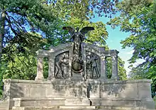 |
1912 | SU4195812471 50.9102°N 1.4046°W |
||||
| Tower House | 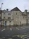 |
18th to 19th century | SU4207610926 50.8963°N 1.4031°W |
||||
| Town Quay - Pair of K6 telephone kiosks | 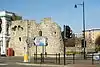 |
1935 | SU4196510975 50.8967°N 1.4046°W |
A pair of standard K6 style telephone booths designed by Giles Gilbert Scott. They are glazed on all four sides, built of red-painted cast iron and topped with a shallow dome-style roof. | |||
| Town Walls: Eastern section | 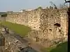 |
14th century | SU4210311060 50.8975°N 1.4027°W |
Section of wall running along Back of the Walls to Briton Street. Remains of mediaeval city walls. Rubble walls from 5 to 8 feet in height. | |||
| Town Walls: Fragment near East Street | 14th century | SU4214911503 50.9015°N 1.4020°W |
Remains of mediaeval city walls. Built of stone rubble. About 8 feet in height. | ||||
| Townhill Park House | 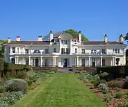 |
1795 | SU4518015064 50.9333°N 1.3584°W |
||||
| Townhill Park House - former Stable Block | ca. 1830s | SU4518315005 50.9327°N 1.3584°W |
|||||
| Trafalgar Dry Dock | 1905 | SU4222610658 50.8939°N 1.4010°W |
|||||
| Tudor House Museum – Archway from St. Denys Priory | 14th century | SU4182811277 50.8995°N 1.4066°W |
|||||
| Tudor House Museum – Two carved stone pedestals | 1743 | SU4184111275 50.8994°N 1.4064°W |
|||||
| Union Castle House | 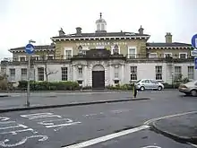 |
1847 | SU4246910983 50.8968°N 1.3975°W |
||||
| 1 Vespasian Road | mid 19th century | SU4369013576 50.9200°N 1.3798°W |
|||||
| Water Gate Tower | 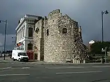 |
14th and 15th century | SU4197210976 50.8967°N 1.4045°W |
The remains of the Watergate, the south gate of the town comprising a drum tower of three storeys and part of fourth storey with three arched windows. Scheduled as an ancient monument. | |||
| Watts Monument | 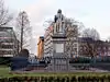 |
1861 | SU4184212402 50.9096°N 1.4062°W |
||||
| Weigh House Vault | late 14th century | SU4193311117 50.8980°N 1.4051°W |
|||||
| Westfield House | early 19th century | SU4416515985 50.9416°N 1.3728°W |
|||||
| 8 Westgate Street | 18th century | SU4181011225 50.8990°N 1.4068°W |
|||||
| 9 & 10 Westgate Street | 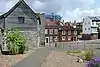 |
early 19th century | SU4181611222 50.8990°N 1.4067°W |
||||
| Wight House | 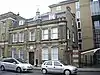 |
1896 | SU4265210996 50.8969°N 1.3949°W |
||||
| 1 to 4 Winkle Street | mid 19th century | SU4206310948 50.8965°N 1.4033°W |
|||||
| 5 to 8 Winkle Street | mid 19th century | SU4205110973 50.8967°N 1.4034°W |
|||||
| Woodmill bridge | 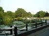 |
early 18th century | SU4392215223 50.9348°N 1.3763°W |
||||
| Woodmill fish house | late 18th or early 19th century | SU4389615292 50.9354°N 1.3767°W |
|||||
| Woodmill Lane drinking fountain | 1897 | SU4424115046 50.9332°N 1.3718°W |
|||||
| Woolston railway station | 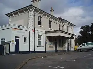 |
ca. 1860 | SU4390911234 50.8989°N 1.3770°W |
||||
| Woolwich House |  |
1850–1860 | SU4204311328 50.8999°N 1.4035°W |
||||
| The Stables, Wrights Hill | mid 19th century | SU4505610727 50.8943°N 1.3607°W |
|||||
| Wyndham Court | 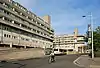 |
1966–1969 | SU4149912264 50.9084°N 1.4111°W |
||||
Notes
- A Location is given first as a grid reference, based on the British national grid reference system (or OSGB36) of the Ordnance Survey;[5] and second as World Geodetic System 84 coordinates, used by the Global Positioning System.
- B Unless otherwise stated, the descriptions are based on those on the English Heritage database.
- C The English Heritage database is the official listing and includes a description of the property, the reasons for designation, the date of listing and an extract from the Ordnance Survey map at a scale of 1:2500 pinpointing the exact location of the building.
- D The Images of England database includes the details of the property from the English Heritage database with a photograph of the listed building.
- E The British Listed Buildings database also includes the details of the property from the English Heritage database, together with links to Google/street view, Ordnance Survey and Bing maps/birds eye view.
References
- Calculated from a count of the entries on Southampton City Council's "Listed Buildings in Southampton" Archived 2008-10-01 at the Wayback Machine dated 9 January 2012, with duplicate entries eliminated.
- "Planning (Listed Buildings and Conservation Areas) Act 1990 (c. 9)". The UK Statute Law Database. Ministry of Justice. 14 January 2010. Archived from the original on 18 April 2010. Retrieved 17 March 2012.
- "How we are run". English Heritage. 2012. Retrieved 17 March 2012.
- "Listed Buildings". English Heritage. 2010. Archived from the original on 24 January 2013. Retrieved 17 March 2012.
- "Guide to National Grid". Ordnance Survey. 2012. Archived from the original on 27 October 2007. Retrieved 5 February 2012.
Sources
- Southampton City Council: Historic Environment Record – Listed Buildings in Southampton
- British Listed Buildings – Listed Buildings in Southampton
