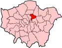
Grade I and II* listed buildings in the London Borough of Hackney
There are over 9,000 Grade I listed buildings and 20,000 Grade II* listed buildings in England. This page is a list of these buildings in the London Borough of Hackney.
Grade I
| Name | Location | Type | Completed [note 1] | Date designated | Grid ref.[note 2] Geo-coordinates |
Entry number [note 3] | Image |
|---|---|---|---|---|---|---|---|
| Church of St Chad | Haggerston, Hackney | Church | 1868–69 | 3 January 1950 | TQ3373783176 51°31′54″N 0°04′24″W |
1265793 | .jpg.webp) Church of St Chad |
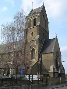
| Church of St Columba | Hackney | Church | 1868-9 | 3 January 1950 | TQ3344083459 51°32′03″N 0°04′39″W |
1226862 |  Church of St Columba |
| Church of St Leonard | Shoreditch, Hackney | Parish Church | 1736 | 3 January 1950 | TQ3348082632 51°31′37″N 0°04′38″W |
1235382 | |
| Church of St Matthias | Stoke Newington, Hackney | Church | 1851 | 1 September 1953 | TQ3325285488 51°33′09″N 0°04′46″W |
1265031 | |
| Church of St Michael | Hackney | Church | 1863-5 | 3 January 1950 | TQ3309582352 51°31′28″N 0°04′58″W |
1265204 |  Church of St Michael |
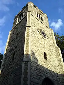
| Old Tower of Former Church of St Augustine | Hackney | Tower | Earlier origin | 24 April 1951 | TQ3499385007 51°32′52″N 0°03′16″W |
1265635 | |
| St Columba's Vicarage, with Link to Church | Hackney | Vicarage | 1873-4 | 4 February 1975 | TQ3345883477 51°32′04″N 0°04′38″W |
1265658 | 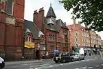 St Columba's Vicarage, with Link to Church |
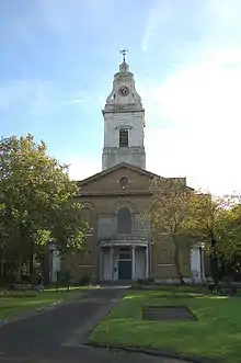
| The Museum of the Home | Hackney | Museum | c. 1715 | 3 January 1950 | TQ3353383179 51°31′54″N 0°04′35″W |
1226772 |


Grade II*
| Name | Location | Type | Completed [note 1] | Date designated | Grid ref.[note 2] Geo-coordinates |
Entry number [note 3] | Image |
|---|---|---|---|---|---|---|---|
| St Mary's Old Church | Hackney | Church | Early 16th century | 1 September 1953 | TQ3286086459 51°33′41″N 0°05′05″W |
1235419 |  St Mary's Old Church |
| St Mary's New Church | Hackney | Church | 1858 | 1 September 1953 | TQ3287986400 51°33′39″N 0°05′04″W |
1265056 |  St Mary's New Church |
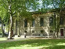
| Ancillary Building to North of Engine House of Metropolitan Water Board | Hackney | Industrial Building | 1854–56 | 27 April 1987 | TQ3229986912 51°33′56″N 0°05′34″W |
1235562 |  |
| Church of St Andrew | Hackney | Church | 1883-4 | 9 December 1988 | TQ3314387497 51°34′14″N 0°04′49″W |
1264896 | .jpg.webp) Church of St Andrew |
| Church of St Barnabas | Hackney | Church | 1910 | 24 April 1951 | TQ3380385537 51°33′10″N 0°04′17″W |
1265135 | .jpg.webp) Church of St Barnabas |
| Church of St John | Hackney | Parish Church | 1792-7 | 24 April 1951 | TQ3507785151 51°32′57″N 0°03′12″W |
1226959 | |
| Church of St John of Jerusalem | Hackney | Parish Church | 1845-8 | 24 April 1951 | TQ3559984202 51°32′26″N 0°02′46″W |
1226409 |  Church of St John of Jerusalem |
| Church of St John the Baptist | Hoxton, Hackney | Church | Victorian | 3 January 1950 | TQ3302783032 51°31′50″N 0°05′01″W |
1235285 | |
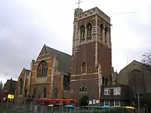
| Church of St Mark | Dalston, Hackney | Church | 1864–66 | 4 February 1975 | TQ3388585155 51°32′58″N 0°04′14″W |
1265134 |  Church of St Mark |
| Church of St Mary of Eton with St Augustine | Hackney | Church | 1880 | 24 April 1951 | TQ3665684782 51°32′43″N 0°01′50″W |
1226605 | |
| Clergy House to West of Church of St Michael | Hackney | Clergy House | 1870 | 4 February 1975 | TQ3306482358 51°31′28″N 0°05′00″W |
1226961 |  Clergy House to West of Church of St Michael |
| Engine House of Metropolitan Water Board | Hackney | Engine house | 1854-6 | 16 May 1972 | TQ3231486884 51°33′55″N 0°05′33″W |
1226755 | 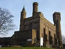 Engine House of Metropolitan Water Board |
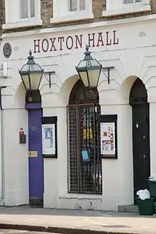
| Hoxton Hall | Hackney | Music Hall | 1863 | 28 June 1972 | TQ3328283186 51°31′55″N 0°04′48″W |
1226830 | |
| Niche in North West Corner of Forecourt of the Museum of the Home | Hackney | Wall | 4 February 1975 | TQ3349183229 51°31′56″N 0°04′37″W |
1265687 | 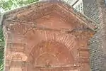 Niche in North West Corner of Forecourt of the Museum of the Home | |
| Pond House | Hackney | Villa | c. 1800 | 24 April 1951 | TQ3498485949 51°33′23″N 0°03′16″W |
1226931 |  Pond House |
| Refreshment Rooms | Hackney | Villa | Late 18th century | 1 September 1953 | TQ3275486438 51°33′40″N 0°05′11″W |
1226509 |  Refreshment Rooms |
| Sisters' House and School to North of Church of St Columba | Hackney | House | 1898 | 4 February 1975 | TQ3343483481 51°32′04″N 0°04′39″W |
1265691 | |
| St Chad's Vicarage | Hackney | Vicarage | c. 1870 | 4 February 1975 | TQ3373983157 51°31′53″N 0°04′24″W |
1226697 | |
| St Michael's Church School | Hackney | Church School | 1870 | 4 February 1975 | TQ3304882367 51°31′28″N 0°05′01″W |
1226884 | 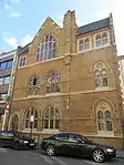 St Michael's Church School |
| Church of the Good Shepherd, Upper Clapton | Hackney | Church | 1892-5 | 12 September 1969 | TQ3407287831 51°34′24″N 0°04′00″W |
1235310 | 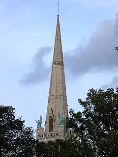 Church of the Good Shepherd, Upper Clapton |
| The Hackney Empire | Hackney | Television Studio | 1950's | 28 June 1972 | TQ3491184748 51°32′44″N 0°03′21″W |
1226960 | 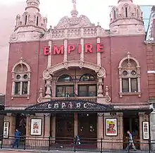 The Hackney Empire |
| The New Lansdowne Club | Hackney | House | Early 18th century | 24 April 1951 | TQ3492884226 51°32′27″N 0°03′21″W |
1265590 | |
| United Reformed Church | Hackney | Church | 1869–91 | 7 May 1974 | TQ3515985508 51°33′08″N 0°03′07″W |
1265632 | .jpg.webp) United Reformed Church |
| 81 and 83 Stoke Newington Church Street | Hackney | House | Early to mid 18th century | 1 September 1953 | TQ3331186548 51°33′43″N 0°04′42″W |
1265043 |  81 and 83 Stoke Newington Church Street |
| 85 and 87 Stoke Newington Church Street | Hackney | House | Early to mid 18th century | 1 September 1953 | TQ3329786544 51°33′43″N 0°04′42″W |
1235420 | |
| 187, 189, and 191 High Street | Hackney | House | Early 18th century | 1 September 1953 | TQ3361686613 51°33′45″N 0°04′26″W |
1235537 |  187, 189, and 191 High Street |
| 91–101 Worship Street | Hackney | Dwelling | 1862 | 3 January 1950 | TQ3317582098 51°31′20″N 0°04′55″W |
1235558 |  91–101 Worship Street |
| 16 Charles Square | Hackney | House | Early to mid 18th century | 3 January 1950 | TQ3294082635 51°31′37″N 0°05′06″W |
1265891 |  16 Charles Square |
| Sutton House, 2 and 4 Homerton High Street | Hackney | House | c. 1530 | 24 April 1951 | TQ3527685090 51°32′55″N 0°03′02″W |
1226810 |  Sutton House, 2 and 4 Homerton High Street |
Notes
- The date given is the date used by Historic England as significant for the initial building or that of an important part in the structure's description.
- Sometimes known as OSGB36, the grid reference is based on the British national grid reference system used by the Ordnance Survey.
- The "List Entry Number" is a unique number assigned to each listed building and scheduled monument by Historic England.
External links
 Media related to Grade I listed buildings in the London Borough of Hackney at Wikimedia Commons
- Media related to Grade II* listed buildings in the London Borough of Hackney at Wikimedia Commons
This article is issued from Wikipedia. The text is licensed under Creative Commons - Attribution - Sharealike. Additional terms may apply for the media files.