Grade I and II* listed buildings in the London Borough of Sutton
There are over 9,000 Grade I listed buildings and 20,000 Grade II* listed buildings in England. This page is a list of these buildings in the London Borough of Sutton.
Grade I
| Name | Location | Type | Completed [note 1] | Date designated | Grid ref.[note 2] Geo-coordinates |
Entry number [note 3] | Image |
|---|---|---|---|---|---|---|---|
| Beddington Place (Great Hall only) | Beddington, Sutton | Bell Tower | 1850 | 21 January 1954 | TQ2962165302 51°22′19″N 0°08′21″W |
1065672 | 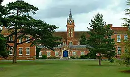 Beddington Place (Great Hall only) |
Grade II*
| Name | Location | Type | Completed [note 1] | Date designated | Grid ref.[note 2] Geo-coordinates |
Entry number [note 3] | Image |
|---|---|---|---|---|---|---|---|
| Carshalton House | Carshalton | House | 1696–1713 | 16 March 1954 | TQ2755164460 51°21′54″N 0°10′09″W |
1065627 | 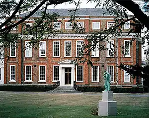 Carshalton House |
| Church of All Saints | Carshalton | Church | 12th century | 16 March 1954 | TQ2798464469 51°21′54″N 0°09′47″W |
1065683 | 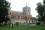 Church of All Saints |
| Church of All Saints | Sutton | Church | 19th century | 28 August 1953 | TQ2586165281 51°22′22″N 0°11′35″W |
1065697 | |
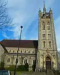
| Church of St Dunstan | Cheam, Sutton | Church | 13th century | 26 January 1971 | TQ2428263916 51°21′39″N 0°12′59″W |
1065676 | 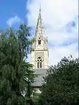 Church of St Dunstan |
| Hermitage or Grotto at Carshalton House | Carshalton | Grotto | Before 1721 | 16 March 1954 | TQ2760764379 51°21′51″N 0°10′06″W |
1357608 | 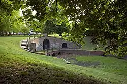 Hermitage or Grotto at Carshalton House |
| No. 19 Park Hill | Sutton | House | c. 1867 | 1 March 1974 | TQ2755064024 51°21′40″N 0°10′10″W |
1183738 | 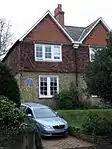 No. 19 Park Hill |
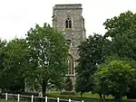
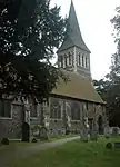
| Parish Church of St Mary the Virgin | Beddington, Sutton | Church | 14th or 15th century | 21 January 1954 | TQ2956865249 51°22′17″N 0°08′24″W |
1065670 | 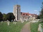 Parish Church of St Mary the Virgin |
| Pigeon House to North West of Beddington Place | Beddington, Sutton | Dovecote | Early 18th century | 21 January 1954 | TQ2954165374 51°22′22″N 0°08′25″W |
1065674 | 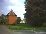 Pigeon House to North West of Beddington Place |
| Remains of Old Church of St Dunstan, Now known as the Lumley Chapel | Cheam, Sutton | Church | 12th century | 28 August 1953 | TQ2429963900 51°21′38″N 0°12′58″W |
1183440 | 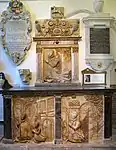 Remains of Old Church of St Dunstan, Now known as the Lumley Chapel |
| Water Pavilion at Carshalton House | Carshalton | Orangery | Before 1721 | 16 March 1954 | TQ2771464483 51°21′54″N 0°10′01″W |
1183926 | 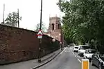 Water Pavilion at Carshalton House |
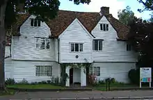
| Whitehall | Cheam, Sutton | House | 16th century | 28 August 1953 | TQ2422463766 51°21′34″N 0°13′02″W |
1357580 | |
| Church of St Nicholas | St Nicholas Road, Sutton | Church | 1864 | 1 March 1974 | TQ2577164158 51°21′45″N 0°11′42″W |
1065629 |
Grade II
| Name | Location | Type | Completed [note 1] | Date designated | Grid ref.[note 2] Geo-coordinates |
Entry number [note 3] | Image |
|---|---|---|---|---|---|---|---|
| Trinity Church | Cheam Road, Sutton | Church | 1907 | 1 March 1974 | TQ2561364111 51°21′42″N 0°11′44″W |
1200708 |
Notes
- The date given is the date used by Historic England as significant for the initial building or that of an important part in the structure's description.
- Sometimes known as OSGB36, the grid reference is based on the British national grid reference system used by the Ordnance Survey.
- The "List Entry Number" is a unique number assigned to each listed building and scheduled monument by Historic England.
External links
 Media related to Grade I listed buildings in the London Borough of Sutton at Wikimedia Commons
- Media related to Grade II* listed buildings in the London Borough of Sutton at Wikimedia Commons
| Districts |
|  |
|---|---|---|
| Attractions | ||
| Places of worship | ||
| Parks and open spaces | ||
| Constituencies | ||
| Rail and tram stations | ||
| Other topics | ||
| ||
This article is issued from Wikipedia. The text is licensed under Creative Commons - Attribution - Sharealike. Additional terms may apply for the media files.