Grade I and II* listed buildings in the Royal Borough of Kingston upon Thames
There are over 9,000 Grade I listed buildings and 20,000 Grade II* listed buildings in England. This page is a list of these buildings in the Royal Borough of Kingston upon Thames.
Grade I
| Name | Location | Type | Completed [note 1] | Date designated | Grid ref.[note 2] Geo-coordinates |
Entry number [note 3] | Image |
|---|---|---|---|---|---|---|---|
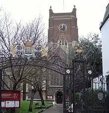
| Church of All Saints | Kingston upon Thames | Church | Norman | 30 July 1951 | TQ1790369300 51°24′38″N 0°18′22″W |
1358437 | |
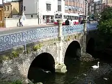
| Clattern Bridge | Kingston upon Thames | Bridge | 12th century with later alterations | 30 July 1951 | TQ1786169094 51°24′31″N 0°18′24″W |
1080064 | |
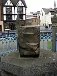
| Coronation Stone | Kingston upon Thames | Balustrade | Mid 19th century | 6 October 1983 | TQ1786769069 51°24′30″N 0°18′24″W |
1080066 |
Grade II*
| Name | Location | Type | Completed [note 1] | Date designated | Grid ref.[note 2] Geo-coordinates |
Entry number [note 3] | Image |
|---|---|---|---|---|---|---|---|
| Chantry Chapel of St Mary Magdalene | Kingston upon Thames | School | 1951 | 30 July 1951 | TQ1857569358 51°24′39″N 0°17′47″W |
1358425 | 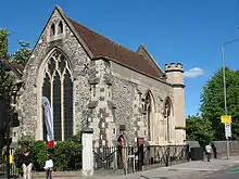 Chantry Chapel of St Mary Magdalene |
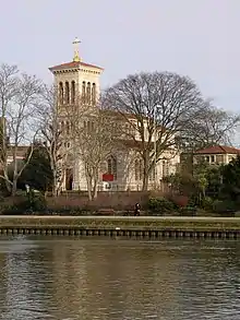
| Church of St Raphael | Kingston upon Thames | Church | 1847-8 | 24 December 1968 | TQ1782368365 51°24′08″N 0°18′27″W |
1080045 | |
| Cleave's Almshouses | Kingston upon Thames | Almshouse | 1668 | 30 July 1951 | TQ1847669366 51°24′39″N 0°17′52″W |
1184584 |  |
| Coombe Conduit House | Kingston upon Thames | Tunnel | 1538–1540 | 30 May 1951 | TQ2049469841 51°24′53″N 0°16′07″W |
1080099 | |
| Druid's Head Public House | Kingston upon Thames | Public House | 17th century | 6 October 1983 | TQ1788369161 51°24′33″N 0°18′23″W |
1184751 | 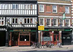 Druid's Head Public House |
| Gallows Conduit House (in Grounds of Hampton Spring) | Kingston upon Thames | Conduit House | 1538–1540 | 30 May 1951 | TQ2004670220 51°25′06″N 0°16′30″W |
1080062 | |
| Kingston Bridge | Kingston upon Thames | Bridge | 1825-8 | 30 July 1951 | TQ1773669370 51°24′40″N 0°18′31″W |
1300232 | |
| Market House | Kingston upon Thames | Building | 1706 | 10 June 1983 | TQ1789569226 51°24′35″N 0°18′23″W |
1358428 | 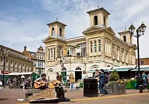 Market House |
| 105 London Road | Kingston upon Thames | Building | Late C17/C18 | 6 October 1983 | TQ1857169361 51°24′39″N 0°17′47″W |
1184600 | |
| 37–41 High Street | Kingston upon Thames | House | 16th century | 30 July 1951 | TQ1780268900 51°24′25″N 0°18′28″W |
1358459 | 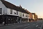 37–41 High Street |
| Picton House | Kingston upon Thames | House | 1740s | 20 February 1970 | TQ1778168961 51°24′27″N 0°18′29″W |
1080069 |


Notes
- The date given is the date used by Historic England as significant for the initial building or that of an important part in the structure's description.
- Sometimes known as OSGB36, the grid reference is based on the British national grid reference system used by the Ordnance Survey.
- The "List Entry Number" is a unique number assigned to each listed building and scheduled monument by Historic England.
External links
 Media related to Grade I listed buildings in the Royal Borough of Kingston upon Thames at Wikimedia Commons
- Media related to Grade II* listed buildings in the Royal Borough of Kingston upon Thames at Wikimedia Commons
| Districts |  | |
|---|---|---|
| Attractions | ||
| Bridges and tunnels | ||
| Parks and open spaces | ||
| Constituencies | ||
| Rail stations | ||
| Places of worship | ||
| Sport | ||
| Other topics | ||
| ||
This article is issued from Wikipedia. The text is licensed under Creative Commons - Attribution - Sharealike. Additional terms may apply for the media files.