Graft-De Rijp
Graft-De Rijp (![]() pronunciation ) is a former municipality in the Netherlands, in the province of North Holland. Since 2015 it has been a part of Alkmaar.
pronunciation ) is a former municipality in the Netherlands, in the province of North Holland. Since 2015 it has been a part of Alkmaar.
Graft-De Rijp | |
|---|---|
Former municipality | |
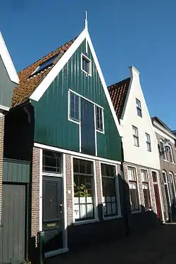 Traditional houses in De Rijp | |
 Flag  Coat of arms | |
.svg.png.webp) Location in North Holland | |
| Coordinates: 52°33′N 4°51′E | |
| Country | Netherlands |
| Province | North Holland |
| Municipality | Alkmaar |
| Established | 1 August 1970 |
| Area | |
| • Total | 21.76 km2 (8.40 sq mi) |
| • Land | 20.03 km2 (7.73 sq mi) |
| • Water | 1.73 km2 (0.67 sq mi) |
| Elevation | −2 m (−7 ft) |
| Population (January 2019)[3] | |
| • Total | data missing |
| Time zone | UTC+1 (CET) |
| • Summer (DST) | UTC+2 (CEST) |
| Postcode | 1483–1488, 1536 |
| Area code | 0299 |
| Website | www |
It is twinned with Chalfont St Giles in England.
Population centres
The municipality of Graft-De Rijp consisted of the following towns, villages and/or districts: De Rijp, Graft, Markenbinnen, Noordeinde, Oost-Graftdijk, Starnmeer, West-Graftdijk.
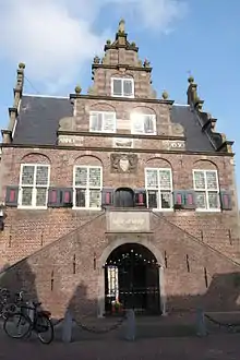
 Town Hall of Graft, built in 1613 in the style of Hendrick de Keyser
Local government
The municipal council of Graft-De Rijp consisted of 13 seats, which were divided as follows:
References
- "Kerncijfers wijken en buurten 2020" [Key figures for neighbourhoods 2020]. StatLine (in Dutch). CBS. 24 July 2020. Retrieved 19 September 2020.
- "Postcodetool for 1483HA". Actueel Hoogtebestand Nederland (in Dutch). Het Waterschapshuis. Archived from the original on 21 September 2013. Retrieved 4 March 2014.
- "Bevolkingsontwikkeling; regio per maand" [Population growth; regions per month]. CBS Statline (in Dutch). CBS. 1 January 2019. Retrieved 1 January 2019.
External links
 Media related to Graft-De Rijp at Wikimedia Commons
- Official website
This article is issued from Wikipedia. The text is licensed under Creative Commons - Attribution - Sharealike. Additional terms may apply for the media files.
