Graham Island
Graham Island (Haida: Kiis Gwaay) is the largest island in the Haida Gwaii archipelago (formerly the Queen Charlotte Islands), lying off the coast of British Columbia, Canada.[1] It is separated only by a narrow channel from the other principal island of the group, Moresby Island (Gwaii Haanas in the language of the Haida people). It has a population of 4,475 (2001 census), an area of 6,361 km2 (2,456 sq mi), and is the 101st largest island in the world and Canada's 22nd largest island.
| Kiis Gwaay | |
|---|---|
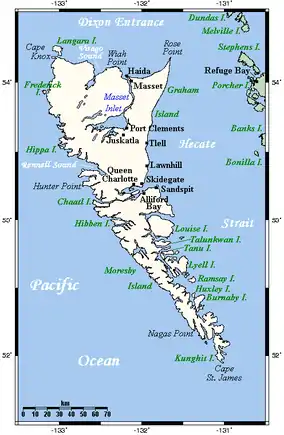 Haida Gwaii, off the British Columbia Coast. Graham Island is the large northern island. Alaska is the next land to the north of this map. | |
 Graham Island | |
| Geography | |
| Location | Pacific Ocean |
| Coordinates | 53°40′N 132°30′W |
| Archipelago | Haida Gwaii |
| Area | 6,361 km2 (2,456 sq mi) |
| Highest elevation | 1,119 m (3671 ft) |
| Highest point | TlldaGaaw Jii.ngasii (Mt La Perouse) |
| Administration | |
Canada | |
| Province | British Columbia |
| Largest settlement | Queen Charlotte City (pop. 948) |
| Demographics | |
| Population | 4,475 (2001) |
| Pop. density | 0.70/km2 (1.81/sq mi) |
Graham Island was named in 1853 by James Charles Prevost, commander of HMS Virago, for Sir James Graham, 2nd Baronet, who was First Lord of the Admiralty at the time.[2]
Communities
Attractions
See also
References
- "Graham Island". BC Geographical Names.
- Middleton, Lynn (1969). Place Names of the Pacific Northwest Coast. Victoria: Elldee Publishing. p. 92. OCLC 16729415.
| Authority control |
|
|---|
This article is issued from Wikipedia. The text is licensed under Creative Commons - Attribution - Sharealike. Additional terms may apply for the media files.