Grainfield, Kansas
Grainfield is a city in Gove County, Kansas, United States. As of the 2010 census, the city population was 277.[6]
Grainfield, Kansas | |
|---|---|
 Grainfield during Christmas season (2006) | |
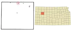 Location within Gove County and Kansas | |
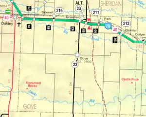 KDOT map of Gove County (legend) | |
| Coordinates: 39°6′51″N 100°28′3″W | |
| Country | United States |
| State | Kansas |
| County | Gove |
| Founded | 1879 |
| Incorporated | 1887 |
| Named for | Wheat fields |
| Area | |
| • Total | 0.46 sq mi (1.20 km2) |
| • Land | 0.46 sq mi (1.20 km2) |
| • Water | 0.00 sq mi (0.00 km2) |
| Elevation | 2,812 ft (857 m) |
| Population | |
| • Total | 277 |
| • Estimate (2019)[3] | 244 |
| • Density | 528.14/sq mi (203.70/km2) |
| Time zone | UTC-6 (CST) |
| • Summer (DST) | UTC-5 (CDT) |
| ZIP code | 67737 |
| Area code | 785 |
| FIPS code | 20-27200 [4] |
| GNIS ID | 0471345 [5] |
| Website | Info |
History
Grainfield had its start in the year 1879 by the building of the railroad through that territory.[7] It was named for the wheat fields in the vicinity.[8]
The first post office in Grainfield was established in May, 1879.[9]
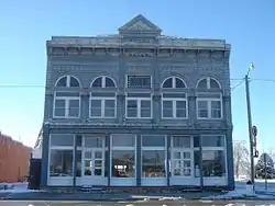
The Grainfield Opera House is listed on the National Register of Historic Places.
Geography
Grainfield is located at 39°6′51″N 100°28′3″W (39.114101, -100.467540).[10] According to the United States Census Bureau, the city has a total area of 0.48 square miles (1.24 km2), all of it land.[11]
Demographics
| Historical population | |||
|---|---|---|---|
| Census | Pop. | %± | |
| 1880 | 77 | — | |
| 1890 | 99 | 28.6% | |
| 1900 | 115 | 16.2% | |
| 1910 | 309 | 168.7% | |
| 1920 | 290 | −6.1% | |
| 1930 | 343 | 18.3% | |
| 1940 | 341 | −0.6% | |
| 1950 | 371 | 8.8% | |
| 1960 | 389 | 4.9% | |
| 1970 | 374 | −3.9% | |
| 1980 | 417 | 11.5% | |
| 1990 | 357 | −14.4% | |
| 2000 | 327 | −8.4% | |
| 2010 | 277 | −15.3% | |
| 2019 (est.) | 244 | [3] | −11.9% |
| U.S. Decennial Census | |||
2010 census
As of the census[2] of 2010, there were 277 people, 127 households, and 84 families residing in the city. The population density was 577.1 inhabitants per square mile (222.8/km2). There were 162 housing units at an average density of 337.5 per square mile (130.3/km2). The racial makeup of the city was 100.0% White.
There were 127 households, of which 23.6% had children under the age of 18 living with them, 55.9% were married couples living together, 6.3% had a female householder with no husband present, 3.9% had a male householder with no wife present, and 33.9% were non-families. 33.1% of all households were made up of individuals, and 15.8% had someone living alone who was 65 years of age or older. The average household size was 2.18 and the average family size was 2.71.
The median age in the city was 46.2 years. 20.9% of residents were under the age of 18; 7.2% were between the ages of 18 and 24; 20.9% were from 25 to 44; 28.9% were from 45 to 64; and 22% were 65 years of age or older. The gender makeup of the city was 47.3% male and 52.7% female.
2000 census
As of the census[4] of 2000, there were 327 people, 141 households, and 93 families residing in the city. The population density was 690.3 people per square mile (268.6/km2). There were 159 housing units at an average density of 335.7/sq mi (130.6/km2). The racial makeup of the city was 97.25% White, 1.53% from other races, and 1.22% from two or more races. Hispanic or Latino of any race were 3.06% of the population.
There were 141 households, out of which 26.2% had children under the age of 18 living with them, 57.4% were married couples living together, 5.0% had a female householder with no husband present, and 34.0% were non-families. 34.0% of all households were made up of individuals, and 21.3% had someone living alone who was 65 years of age or older. The average household size was 2.32 and the average family size was 2.97.
In the city, the population was spread out, with 27.8% under the age of 18, 4.6% from 18 to 24, 21.4% from 25 to 44, 24.2% from 45 to 64, and 22.0% who were 65 years of age or older. The median age was 42 years. For every 100 females, there were 90.1 males. For every 100 females age 18 and over, there were 82.9 males.
The median income for a household in the city was $33,958, and the median income for a family was $44,167. Males had a median income of $29,844 versus $20,625 for females. The per capita income for the city was $17,443. About 9.6% of families and 10.8% of the population were below the poverty line, including 15.8% of those under age 18 and 9.3% of those age 65 or over.
Education
Grainfield is served by USD 292 Wheatland. The Wheatland High School mascot is Thunderhawks.[12]
Gallery
References
- "2019 U.S. Gazetteer Files". United States Census Bureau. Retrieved July 24, 2020.
- "U.S. Census website". United States Census Bureau. Retrieved 2012-07-06.
- "Population and Housing Unit Estimates". United States Census Bureau. May 24, 2020. Retrieved May 27, 2020.
- "U.S. Census website". United States Census Bureau. Retrieved 2008-01-31.
- "US Board on Geographic Names". United States Geological Survey. 2007-10-25. Retrieved 2008-01-31.
- "2010 City Population and Housing Occupancy Status". U.S. Census Bureau. Retrieved September 1, 2011.
- Blackmar, Frank Wilson (1912). Kansas: A Cyclopedia of State History, Embracing Events, Institutions, Industries, Counties, Cities, Towns, Prominent Persons, Etc. Standard Publishing Company. pp. 772.
- Heim, Michael (2007). Exploring Kansas Highways. p. 29.
- "Kansas Post Offices, 1828-1961". Kansas Historical Society. Retrieved 10 June 2014.
- "US Gazetteer files: 2010, 2000, and 1990". United States Census Bureau. 2011-02-12. Retrieved 2011-04-23.
- "US Gazetteer files 2010". United States Census Bureau. Archived from the original on 2012-01-25. Retrieved 2012-07-06.
- "USD 292 Wheatland". USD 292. Retrieved 7 January 2017.
Further reading
External links
| Wikimedia Commons has media related to Grainfield, Kansas. |
- City
- Schools
- USD 292, local school district
- Maps
- Grainfield City Map, KDOT
Municipalities and communities of Gove County, Kansas, United States | ||
|---|---|---|
| Cities | 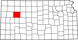 Map of Kansas highlighting Gove County | |
| Ghost towns | ||
| Townships | ||
| Footnotes | ‡This populated place also has portions in an adjacent county or counties | |
| ||