Grano, North Dakota
Grano is a city in Renville County, North Dakota, United States. The population was seven at the 2010 Census,[5] tying Bergen as the second least populous incorporated place in North Dakota (Ruso was the least populous).
Grano, North Dakota | |
|---|---|
 Grano Lounge in Grano | |
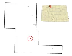 Location of Grano, North Dakota | |
| Coordinates: 48°36′57″N 101°35′15″W | |
| Country | United States |
| State | North Dakota |
| County | Renville |
| Government | |
| • Mayor | Avi Agarwal |
| Area | |
| • Total | 0.29 sq mi (0.76 km2) |
| • Land | 0.29 sq mi (0.76 km2) |
| • Water | 0.00 sq mi (0.00 km2) |
| Elevation | 1,732 ft (528 m) |
| Population | |
| • Total | 7 |
| • Estimate (2019)[3] | 6 |
| • Density | 20.41/sq mi (7.87/km2) |
| Time zone | UTC-6 (Central (CST)) |
| • Summer (DST) | UTC-5 (CDT) |
| Area code(s) | 701 |
| FIPS code | 38-32580 |
| GNIS feature ID | 1029212[4] |
Grano was founded in 1905 along the Soo Line Railroad branch line running east from Kenmare across the northern portion of North Dakota. Several unconfirmed explanations exist regarding how the town got its name.[6] It is generally accepted that the town's name is derived from the Assiniboine, who lived in the area before the settlement of colonizers.
It is part of the Minot Micropolitan Statistical Area.
Geography
Grano is located at 48°36′57″N 101°35′15″W (48.615698, -101.587365).[7]
According to the United States Census Bureau, the city has a total area of 0.30 square miles (0.78 km2), all land.[8]
Demographics
| Historical population | |||
|---|---|---|---|
| Census | Pop. | %± | |
| 1910 | 325 | — | |
| 1920 | 112 | −65.5% | |
| 1930 | 90 | −19.6% | |
| 1940 | 57 | −36.7% | |
| 1950 | 27 | −52.6% | |
| 1960 | 14 | −48.1% | |
| 1970 | 4 | −71.4% | |
| 1980 | 6 | 50.0% | |
| 1990 | 9 | 50.0% | |
| 2000 | 9 | 0.0% | |
| 2010 | 7 | −22.2% | |
| 2019 (est.) | 6 | [3] | −14.3% |
| Source:[9] 2018 Estimate[11] | |||
2010 census
As of the census[2] of 2010, there were 7 people, 3 households, and 3 families residing in the city. The population density was 23.3 inhabitants per square mile (9.0/km2). There were 3 housing units at an average density of 10.0 per square mile (3.9/km2). The racial makeup of the city was 100.0% White.
There were 3 households, of which 100.0% were married couples living together. 0.0% of all households were made up of individuals. The average household size was 2.33 and the average family size was 2.33.
The median age in the city was 52.3 years. 0.0% of residents were under the age of 18; 0.0% were between the ages of 18 and 24; 14.3% were from 25 to 44; 85.7% were from 45 to 64; and 0.0% were 65 years of age or older. The gender makeup of the city was 57.1% male and 42.9% female.
2000 census
As of the census of 2000, there were 9 people, 5 households, and 3 families residing in the city. The population density was 30.2 people per square mile (11.6/km2). There were 5 housing units at an average density of 16.8 per square mile (6.4/km2). The racial makeup of the city was 100.00% White.
There were 5 households, out of which three were married couples living together, and two were non-families. Two households were made up of individuals who were 65 years of age or older. The average household size was 1.80 and the average family size was 2.33.
In the city, the population was spread out, with 11.1% from 18 to 24, 44.4% from 25 to 44, and 44.4% of people aged 45 to 64. The median age was 44 years. For every five females there were four males. For every five females age 18 and over, there were four males.
The median income for a household in the city was $16,250, and the median income for a family was $0. Males had a median income of $0 versus $16,250 for females. The per capita income for the city was $15,000. None of the population and none of the families were below the poverty line.
References
- "2019 U.S. Gazetteer Files". United States Census Bureau. Retrieved July 27, 2020.
- "U.S. Census website". United States Census Bureau. Retrieved 2012-06-14.
- "Population and Housing Unit Estimates". United States Census Bureau. May 24, 2020. Retrieved May 27, 2020.
- "US Board on Geographic Names". United States Geological Survey. October 25, 2007. Retrieved January 31, 2008.
- "2010 Census Redistricting Data (Public Law 94-171) Summary File". American FactFinder. United States Census Bureau. Archived from the original on July 21, 2011. Retrieved May 2, 2011.
- Wick, Douglas A. "Grano (Renville County)". North Dakota Place Names. Retrieved May 7, 2011.
- "US Gazetteer files: 2010, 2000, and 1990". United States Census Bureau. 2011-02-12. Retrieved 2011-04-23.
- "US Gazetteer files 2010". United States Census Bureau. Archived from the original on 2012-01-25. Retrieved 2012-06-14.
- Moffatt, Riley. Population History of Western U.S. Cities & Towns, 1850-1990. Lanham: Scarecrow, 1996, 176.
- United States Census Bureau. "Census of Population and Housing". Retrieved October 23, 2013.
- "Population Estimates". United States Census Bureau. Retrieved June 11, 2019.
Municipalities and communities of Renville County, North Dakota, United States | ||
|---|---|---|
| Cities | 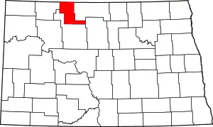 Map of North Dakota highlighting Renville County | |
| Townships |
| |
| Unincorporated communities |
| |
| ||