Graylands Copse
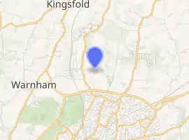
Graylands Copse is a largely inaccessible woodland in Graylands, near Horsham, England.[1]
| Graylands Copse | |
|---|---|
 | |
| |
| Type | Woodland |
| Location | Graylands, Horsham, England |
| OS grid | TQ 17843 34232 |
| Area | 0.01 sq mi (0.02 km2) |
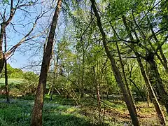
The woodland has a convex outline, being primarily inaccessible at all edges except for an unmaintained opening on the south-western edge, in which a footbridge had existed. The interior is very irregular, defined by dense thickets and dead wood. An unnamed stream cuts through the center of the copse.
A small pit exists in the opposing south-eastern corner, possibly a man-made quarry feature typical of woodland in the area. One former footpath and one track run through Graylands Copse in a north–south direction, neither are maintained or easily accessible.
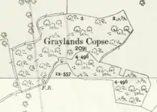
Historical ordinance maps indicate that the eastern central portion (approximately 1⁄6) of Graylands Copse underwent a forest plantation in the mid to late 20th century to define agricultural boundaries.
Notably, a medieval moated site exists 200 metres (656 ft) from Graylands Copse.[2]
References
- Book of Reference to the Plan of the Parish of Henfield p.27
- https://historicengland.org.uk/listing/the-list/list-entry/1010500
