Greiz
Greiz is a town in Thuringia, and it is the capital of the district of Greiz. Greiz is situated in eastern Thuringia on the river White Elster.
Greiz | |
|---|---|
.jpg.webp) Greiz, Thuringia | |
 Coat of arms | |
Location of Greiz within Greiz district  | |
 Greiz  Greiz | |
| Coordinates: 50°39′17″N 12°11′59″E | |
| Country | Germany |
| State | Thuringia |
| District | Greiz |
| Subdivisions | 10 |
| Government | |
| • Mayor | Alexander Schulze (Ind.) |
| Area | |
| • Total | 84.87 km2 (32.77 sq mi) |
| Elevation | 265 m (869 ft) |
| Population (2019-12-31)[1] | |
| • Total | 20,392 |
| • Density | 240/km2 (620/sq mi) |
| Time zone | UTC+01:00 (CET) |
| • Summer (DST) | UTC+02:00 (CEST) |
| Postal codes | 07973 |
| Dialling codes | 03661 |
| Vehicle registration | GRZ, ZR |
| Website | www.greiz.de |
Greiz has a large park in its center (Fürstlich Greizer Park)[2] which is classified as an English garden. Thomasstraße, Burgstraße, Marktstraße, Waldstraße, and Leonhardtstraße with their Jugendstil houses are well known examples of that architectural style.Prof.-Dr.-Friedrich-Schneider-Straße 4 is one of the earliest examples of Art Deco architecture (built in 1911).
History
As with other nearby settlements, the place name (originally Grouts) is of Slavic origin and means gord. The first documented mention of the settlement dates from 1209. The prime location of Greiz on the confluence of the White Elster river and its tributary Göltzsch helped to make it a fast-growing town. It was recognized as a town in the 13th century. Later the House of Reuss, a ruling German dynasty whose male members were all named Heinrich, built 2 castles in Greiz: the "Oberes Schloss" (Upper castle) and the "Unteres Schloss" (Lower castle). Both were built by famous architects and are still considered unique. Greiz became the capital of the Principality of Reuss-Greiz (until 1918).

Between 1934 and 1943 809 people were forcibly sterilized by Nazis in the district hospital in WichmannstraßeThe local old folk's home and the care home submitted 122 sick people to the euthenasia program Aktion T4.
During World War II hundreds of prisoners of war as well as men and women from countries occupied by Nazi Germany worked as forced laborers in Sorgwald near Thalbach, a village about 2 km south-east of Greiz and in other enterprises. At least 102 of them died. There is a memorial for them in the Old Cemetery.
There is also a monument to the officer Kurt von Westernhagen, who refused orders in April 1945 to blow up the bridge and defend the town, for which he was shot by the Gestapo[3]
During World War II, Greiz did not suffer much damage, although 3 of the 5 bridges in town were destroyed. In 1941, Ulf Merbold , who became in 1983 the first astronaut from West Germany was born in 1943.
Greiz has a population of about 20,400 people. The former municipality Neumühle/Elster was merged into Greiz in December 2019.
Economy
In addition to a chemical works and a disused paper factory there are mechanical engineering operations, plastics manufacturing businesses, wood machining enterprises, medical technology, suppliers to the automobile industry, printing houses and breweries. In recent years various high tech businesses (sensor technology, climate simulators, micro-chip production) and environmental technology companies developed.
- Upper castle
 Upper and lower castles
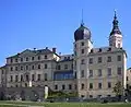 Lower castle
.jpg.webp) View over the town
View over the town The VEB chemical factory at Greiz-Dölau 1979
 The old paper factory
Neigbouring Towns and Districts
The following are the districts adjacent to Greiz:
- In the Greiz district: Zeulenroda-Triebes, Langenwetzendorf, Mohlsdorf-Teichwolframsdorf, Berga/Elster
- In the Vogtlandkreis district (Saxony): Reichenbach im Vogtland, Netzschkau, Elsterberg, Pöhl, Plauen, Rosenbach/Vogtl.
Places adjacent to Greiz | |
|---|---|

Adjacent towns include:
Transport
Greiz station is on the Gera Süd–Weischlitz railway.
Demographics
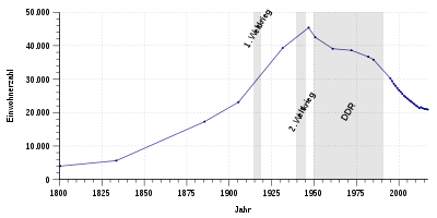
The current population is about 20,400. Like many towns in the former East Germany, Greiz has suffered from population decline in recent years.
Historical population
Number of inhabitants (since 1960 as of 31st December):
|
1800 - 1950 |
1960 - 1999
|
2000 - 2009
|
2010 - 2019
|
Data source since 1994: Thüringian Federal Bureau of Statistics
Notes
- Census 29th October
- Census 31st August
See also
 Media related to Greiz at Wikimedia Commons
References
- "Bevölkerung der Gemeinden, erfüllenden Gemeinden und Verwaltungsgemeinschaften in Thüringen Gebietsstand: 31.12.2019". Thüringer Landesamt für Statistik (in German). August 2020.
- "Übersicht über den Fürstlich Greizer Park" (in German). Freundeskreis Greizer Park e.V. Retrieved 19 May 2019.
- Thüringer Verband der Verfolgten des Naziregimes – Bund der Antifaschisten und Studienkreis deutscher Widerstand 1933–1945 (Hrsg.): Heimatgeschichtlicher Wegweiser zu Stätten des Widerstandes und der Verfolgung 1933–1945. (= Heimatgeschichtliche Wegweiser, Band 8.) Erfurt 2003, ISBN 3-88864-343-0, S. 111 ff.
External links
| Authority control |
|---|
