Grenfell Street, Adelaide
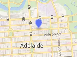
Grenfell Street (34.924°S 138.602°E) is a major street in the north-east quarter of the Adelaide city centre, South Australia.[2] The street runs west-east from King William Street to East Terrace. On the other side of King William Street, it continues as Currie Street. Its intersection with Pulteney Street is encircled by Hindmarsh Square.
Grenfell Street | |
|---|---|
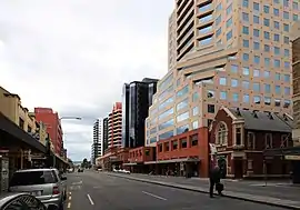 | |
Grenfell Street, looking east from Gawler Place | |
| |
| General information | |
| Type | Street |
| Length | 1.0 km (0.6 mi)[1] |
| Opened | 1837 |
| Major junctions | |
| Western end | King William Street |
| Pulteney Street (Hindmarsh Square), Frome Street | |
| Eastern end | East Terrace |
A dedicated bus lane runs the whole length of both Grenfell and Currie Streets, limiting private vehicles to one lane for most of its length, and carrying nearly all bus traffic traversing the city in an east-west direction. At the eastern end of Grenfell, a dedicated bus track carries buses across East Terrace into the O-Bahn tunnel under Rymill Park.
History
Grenfell Street was named after Pascoe St Leger Grenfell, a Cornish businessman and member of the South Australian Church Society. His significant donation of an acre of land on North Terrace was used for the construction of the Holy Trinity Church — one of the first churches built in the city.[3] Grenfell also donated another 40 acres (16 ha) of country land for the use of the church as glebe lands. This land later became the suburb of Trinity Gardens.
In July 2012, dedicated bus lanes were introduced along the full length of Grenfell Street in both directions, in operation from 7am to 7pm each weekday. When operational, taxis, cyclists and emergency vehicles are also able to use the lane, but private vehicles can only travel up to 100 metres (330 ft) in the bus lane.[4][5]
In December 2016, after the O-Bahn extension tunnel was built underneath Rymill Park at the eastern end of the street, buses formerly routed along North Terrace were permanently routed along Grenfell (although they had been temporarily diverted from North Terrace via East Terrace, since construction of the Botanic Line of the Adelaide trams had begun in early October that year).[6] After this, nearly all buses travelling in an east-west direction across the city use Grenfell.[7]
Description
Grenfell Street runs from King William Street to East Terrace. It is one of the intermediate-width streets of the Adelaide grid, at 1 1⁄2 chains (99 ft; 30 m) wide.
On the other side of King William Street, the western continuation of Grenfell Street is Currie Street, named after Raikes Currie, a member of the South Australian Association and South Australian Company.[8]
The section of the street which runs parallel to Rundle Mall (west of Hindmarsh Square) features many retail outlets, as well as the southern entrances of many of the arcades, side-streets, and eateries of the mall. Office buildings and night spots also populate the street. The eastern end is occupied on the south side by the Tandanya National Aboriginal Cultural Institute, an art and cultural museum also used as a venue for the Adelaide Fringe and other events, and on the north side by the East End Markets redevelopment.
Heritage-listed buildings
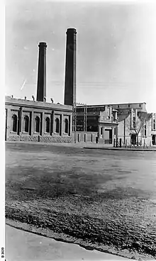
On the corner of Grenfell Street and East Terrace there is the old Grenfell Street Power Station building. Much of the building now houses the Tandanya National Aboriginal Cultural Institute, facing Grenfell Street, which was heritage-listed on the SA Heritage Register in November 1984,[9] while the old converter stations face East Terrace. There is an "Historic Engineering Plaque" on a ground level plinth just east of the north-east corner of the Tandanya building, which was dedicated by the Institution of Engineers, Australia, the Electricity Trust of South Australia and the Adelaide City Council on 6 April 1995.[10]
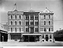
Other heritage-listed buildings in Grenfell Street include:[11]
- the Wiggs Building (former home of stationers E. S. Wigg & Son[12][13]);
- the Crown and Anchor Hotel (first licensed 1853, rebuilt 1880s[14][15]);
- parts of the former Adelaide Fruit and Produce Exchange facing the street;
- the British & Foreign Bible Society office (Bertram Hall); and
- several other office buildings.
Junction list
| Location | km[16] | mi | Destinations | Notes | |
|---|---|---|---|---|---|
| Adelaide city centre | 0 | 0.0 | King William Street | Continues as Currie Street | |
| 0.2 | 0.12 | Gawler Place | |||
| 0.55 | 0.34 | Pulteney Street | |||
| 0.75 | 0.47 | Frome Street | |||
| 1.0 | 0.62 | East Terrace | Continues as the bus-only O-Bahn Busway tunnel under the Adelaide Park Lands | ||
| 1.000 mi = 1.609 km; 1.000 km = 0.621 mi | |||||
See also
![]() Australian Roads portal
Australian Roads portal
References
- Google. "Grenfell Street" (Map). Google Maps. Google.
- 2003 Adelaide Street Directory, 41st Edition. UBD (A Division of Universal Press Pty Ltd). 2003. ISBN 0-7319-1441-4.
- "History of Adelaide Through Street Names - Streets Named on the 23rd May, 1837: Grenfell Street". Archived from the original on 19 February 2009. Retrieved 9 November 2009.
- Installation of bus priority lanes Grenfell Street, Currie Street & East Terrace Department of Planning, Transport & Infrastructure May 2012
- Adelaide bus lanes Australian Bus issue 53 September 2012 page 6
- Siebert, Bension (8 December 2017). "Hundreds more O-Bahn buses to hit "deteriorating" Grenfell St". InDaily. Retrieved 22 December 2020.
- Brennan, Ben (18 December 2017). "Confusion reigns as bus routes change". adelaidenow. Retrieved 22 December 2020.
- "History of Adelaide Through Street Names - Streets Named on the 23rd May, 1837: Currie Street". Archived from the original on 6 May 2009.
- "Heritage Places [241-259 Grenfell Street Adelaide]]". SA Heritage Places Database Search. Retrieved 23 December 2020.
- Institution of Engineers, Australia. SA Division. Engineering Heritage Branch (17 July 1996). "Historic Engineering Marker at the Grenfell Power and East Terrace Converter Stations (Issue 2)" (PDF). Cite journal requires
|journal=(help) - "Heritage Places: Search By Keywords - grenfell AND adelaide". SA Heritage Places Database Search. Retrieved 23 December 2020.
- "Wiggs' Building - 63-69 Grenfell Street ADELAIDE". City of Adelaide. 19 August 2020. Retrieved 24 December 2020.
- City of Adelaide. "Wiggs Building, 63-69 Grenfell Street" (PDF). Heritage of the City of Adelaide. Cite journal requires
|journal=(help) - Stewart, Hannah. "Crown and Anchor Hotel". SA History Hub. Retrieved 24 December 2020.
- "The Crown & Anchor Hotel". Adelaide City Explorer. Retrieved 24 December 2020.
- Google (11 December 2016). "Grenfell Street, Adelaide" (Map). Google Maps. Google. Retrieved 11 December 2016.
Streets and squares of Adelaide city centre | |||||||||||||
|---|---|---|---|---|---|---|---|---|---|---|---|---|---|
| |||||||||||||
| Wikimedia Commons has media related to Grenfell Street. |