Grenzgipfel
The Grenzgipfel (4,618 m)[4] (German for Border Summit) is a peak of Monte Rosa Massif (Pennine Alps), located on the border between Italy and Switzerland.
| Grenzgipfel | |
|---|---|
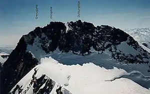 The Grenzgipfel to the left of the Dunantspitze (formerly called Ostspitze) and the Dufourspitze (seen from Nordend) | |
| Highest point | |
| Elevation | 4,618 m (15,151 ft) [1] |
| Prominence | 10 m (33 ft) [2] |
| Parent peak | Dufourspitze |
| Isolation | 0.1 km (0.062 mi) |
| Listing | Italian region high point |
| Coordinates | 45°56′12.3″N 7°52′04.8″E |
| Naming | |
| English translation | Border Summit |
| Language of name | German |
| Geography | |
 Grenzgipfel Location in the Alps | |
| Location | Italian (Piedmont) - Swiss (Valais) border |
| Countries | Italy and Switzerland |
| Parent range | Pennine Alps |
| Topo map | Swiss Federal Office of Topography swisstopo |
| Climbing | |
| First ascent | 12 August 1848 by Johann Madutz and Matthias zum Taugwald.[3] |
The Grenzgipfel is the highest summit on the Italian side of the Monte Rosa massif and the highest point of the entire border between Italy and Switzerland; it is also the culminating point of the Italian region of Piedmont and of the river Ticino drainage basin.
The closest locality is Macugnaga, which is located east of Monte Rosa Massif.
References
- Retrieved from the Swisstopo topographic maps.
- Peakbagger: Grenzgipfel
- Gottlieb Studer, Über Eis und Schnee: Die höchsten Gipfel der Schweiz und die Geschichte ihrer Besteigung, Volume 2, Schmid, Francke & Company, 1899, pp. 78-85
- According to Collomb, the 'false Grenzgipfel' is 4,618 m, while the 'true Grenzgipfel' is 4,596 m. Collomb, Robin G., Pennine Alps Central, London: Alpine Club, 1975, p. 172
External links
This article is issued from Wikipedia. The text is licensed under Creative Commons - Attribution - Sharealike. Additional terms may apply for the media files.