Valais
Valais (UK: /ˈvæleɪ/ VAL-ay, US: /væˈleɪ/ val-AY, French: (Canton du) Valais, French: [valɛ] (![]() listen)), sometimes Wallis (German: (Kanton) Wallis [ˈvalɪs] (
listen)), sometimes Wallis (German: (Kanton) Wallis [ˈvalɪs] (![]() listen)), [3] more formally the Canton of Valais, is one of the 26 cantons forming the Swiss Confederation. It is composed of thirteen districts and its capital and largest city is Sion. The flag of the canton is made of thirteen stars representing the districts, on a white-red background.
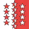
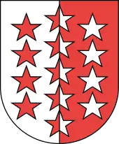
listen)), [3] more formally the Canton of Valais, is one of the 26 cantons forming the Swiss Confederation. It is composed of thirteen districts and its capital and largest city is Sion. The flag of the canton is made of thirteen stars representing the districts, on a white-red background.
Valais
| |
|---|---|
 Flag | |
| Anthem: Notre Valais/Wallis, unser Heimatland | |
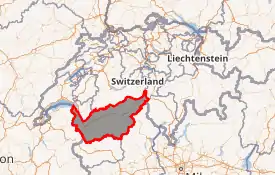
Location in Switzerland
Map of Valais 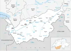 | |
| Coordinates: 46°4′N 7°36′E | |
| Capital | Sion |
| Subdivisions | 143 municipalities, 13 districts |
| Government | |
| • Executive | Conseil d'État, Staatsrat (5) |
| • Legislative | Grand Council (130) |
| Area | |
| • Total | 5,224.49 km2 (2,017.19 sq mi) |
| Population (December 2019)[2] | |
| • Total | 345,525 |
| • Density | 66/km2 (170/sq mi) |
| ISO 3166 code | CH-VS |
| Highest point | 4,634 m (15,203 ft): Monte Rosa |
| Lowest point | 372 m (1,220 ft): Lake Geneva |
| Joined | 1815 |
| Languages | French, German |
| Website | www |
Valais is situated in the southwestern part of the country. It borders the cantons of Vaud and Bern to the north, the cantons of Uri and Ticino to the east, as well as Italy to the south and France to the west. It is one of the three large southern Alpine cantons, along with Ticino and the Grisons. It is a bilingual canton. French and German are its two official languages.
Valais essentially coincides with the valley of the Rhône from its headwaters to Lake Geneva, separating the Pennine Alps from the Bernese Alps. The canton is simultaneously one of the driest regions of Switzerland in its central Rhône valley and among the wettest, having large amounts of snow and rain up on the highest peaks found in Switzerland, such as Monte Rosa and the Matterhorn. Valais is widely known for its tourism industry and for its numerous Alpine resort towns, notably Crans-Montana, Saas Fee, Verbier and Zermatt.
In 1529, Valais became an associate member of the Swiss Confederation and in 1628 it became a republic under the guidance of the prince-bishop of Sion. In 1815, Valais finally entered the Swiss Confederation as a canton.
History
The Romans called the upper Rhône valley Vallis Poenina. The Vallis Poenina was won by the Romans after a great fight at Octodurus (now known as Martigny) in 57 BC and became part of the Gallo-Roman cultural sphere. According to a tradition which can be traced back to the middle of the 8th century, the Theban legion was martyred at Agaunum (now Saint Maurice) about 285 or 302. From 888 onwards the lands were part of the kingdom of Jurane Burgundy.[4]
Valais formed part of the kingdom of Transjurane Burgundy, which fell to the Holy Roman Empire in 1032. It became part of the duchy of Burgundia Minor, which was held from the emperors by the house of Zähringen (which became extinct in 1218). In 999, King Rudolph III of Burgundy gave all temporal rights and privileges to the Bishop of Sion, who was later styled praefect and count of Valais and is still a prince of the Holy Roman Empire. The count-bishops then struggled to defend their area against the Zähringer and then the dukes of Savoy, so that the medieval history of Valais is inextricably linked with that of the diocese of Sion. The Dukes of Savoy, however, succeeded in winning most of the land west of Sion (Lower Valais), while in the upper part of the valley (Upper Valais) there were many feudal lords, such as the lords of Raron, those of La Tour-Châtillon, and the counts of Visp.[4]
About the middle of the 13th century, the large communities (Zenden or tithings) began to develop independence and grow in power. The name Zenden or tithings probably came from a very ancient division of the bishop's manors for administrative and judicial purposes. In the same century the upper part of the valley was colonized by Germans from Hasli(de) in the Canton of Bern. The locals became German speaking, though many Romance local names still remain. In 1354 the liberties of several of the seven Zenden (Sion, Sierre, Leuk, Raron, Visp, Brig and Conches) were confirmed by the Emperor Charles IV.[4]
By the late 14th century, the counts of Savoy acquired the bishopric of Sion. The Zenden resisted his attempts to gather both spiritual and secular power in the valley. In 1375–76, Zenden forces crushed the army of the house of La Tour-Chatillon, and in 1388 utterly defeated the forces of the bishop, the count and his nobles at Visp. The German-speaking Zenden spread further into the valley. Starting in 1384 the Morge stream (a little below Sion) was recognized as the boundary between Savoyard, French-speaking Lower Valais and German-speaking episcopal Upper Valais.
During the Raron affair rebellion in 1414 to 1420, some cantons of the Swiss Confederation took sides in the conflict. Lucerne, Uri and Unterwalden supported the Upper Valais rebels, while Bern supported the noble Raron family. The uprising was successful in driving out the Rarons, and almost brought the Confederation to civil war.[5]
Following the violence of the Raron affair, the canton was the location of the Valais witch trials between 1428 and 1447 in which at least 367 men and women were put to death. This event marks one of the earliest witch scares in late medieval Europe. The phenomenon later spread to other parts of the continent.
With the election of Walther von Supersax of Conches as bishop in 1457, the German-speaking part of the valley finally won the supremacy. At the outbreak of the Burgundian War in 1475 the bishop of Sion and the Zenden made a treaty with Bern. In November of the same year they seized all Lower or Savoyard Valais up to Martigny. In March 1476, after the victory of Grandson, they advanced and captured St Maurice, Évian, Thonon and Monthey. They had to give up the last three districts in 1477, but won them again in 1536. In the treaty of Thonon in 1569, Monthey, Val-d'llliez and Le Bouveret were permanently annexed to Valais. These conquered districts in the Lower Valais were always ruled as subject lands by the bishop and Zenden of the Upper Valais. On March 12, 1529, Valais became an associate member (Zugewandter Ort) of the Swiss Confederation.[4]
Valais resisted the Protestant Reformation, remaining faithful to the Roman Catholic Church. In 1628 Valais became a republic, the République des Sept Dizains/Republik der Sieben Zehenden, under the guidance of the prince-bishop of Sion and the bailli. The bishop remained in power until 1798 when Napoleon's troops invaded Valais and declared a Revolutionary République du Valais (March 16) which was swiftly incorporated (May 1) into the Helvetic Republic until 1802 when it became the separate Rhodanic Republic. In 1810 the Rhodanic Republic was annexed by Napoleonic France as the département of Simplon. Independence was restored in 1813,[6] and on August 4, 1815 Valais finally entered the Swiss Confederation as a canton. In 1845, Valais joined the Catholic separate league (Sonderbund) which led to what is called the Sonderbund War. 99,000 Swiss Federal troops under General Henri Dufour were faced by 79,000 Separatists, but in the end Valais chose not to fight.
Geography
Valais is the third largest canton of Switzerland by area. It is also one of its westernmost and southernmost cantons. With a few exceptions, it lies almost entirely in the Rhône basin, more precisely in the wide Alpine Rhône Valley, above Lake Geneva. The main settlements are all along the Rhône or in its proximity, the largest city being Sion, followed by Martigny, Monthey, Sierre, and Brig-Glis. The canton is traditionally divided into two regions: Lower Valais and Upper Valais, respectively west and east of the forest of Pfynwald, the linguistic border of the canton. While the most populous Lower Valais is French-speaking, Upper Valais is German-speaking.
The Rhône Valley is a central Alpine valley, i.e. it lies well within the Alps and it is shut off from both northern and southern plains. Valais is separated from the Swiss Plateau to the north by the Bernese Alps and from the Po plains to the south by the Valais Alps, respectively north and south of the Rhône. Valais is also one of the three large southern cantons lying partially in the Po basin, therefore south of the Alps, along with Ticino and the Grisons. However, contrary to those two cantons, very few settlements are on the south side of the Alps. The largest regions not drained by the Rhône are the Simplon Valley (Po basin) and two uninhabited areas north of the Sanetsch and the Gemmi Pass (Rhine basin).
The wide, glacial, Rhône valley dominates the geography of the canton. There are many side valleys branching off the main valley, often perpendicularly. These vary from narrow and remote to reasonably populous. Some of the largest side valleys are (from east to east): the Mattertal (including the Saastal), the Val d'Anniviers, the Val d'Hérens, the Val de Bagnes and the Val d'Entremont. These are all south of the Rhône, therefore in the Valais Alps. On the north of the Rhône, in the Bernese Alps, the Lötschental is the only large valley. East of Brig is the valley of Goms, the highest section of the Rhône Valley. The Rhône itself flows in the main valley from east to west from the Rhône Glacier down to Martigny, then in a right angle north to its mouth in Lake Geneva. After the town of Saint-Maurice, the eastern banks of the river belong to the canton of Vaud, although the western banks remain in Valais, down to Le Bouveret, on the shores of Lake Geneva. The main valley is bounded by the Bernese Alps in the north and the Valais Alps in the south, both ranges including numerous over 4,000 metre-high mountains, which are the highest in the country. Notables mountains include Monte Rosa (highest), reaching 4,634 metres (15,203 ft), and the Finsteraarhorn (most prominent), reaching 4,274 metres (14,022 ft). Other iconic mountains are the Matterhorn and the Jungfrau, for a complete list, see list of mountains of Valais. Located there are numerous glaciers including several of the largest in the Alps, such as the Aletsch Glacier and the Gorner Glacier. Other ranges situated partially in Valais are the Chablais Alps, the Mont Blanc Massif, the Uri Alps, the Gotthard Massif and the Lepontine Alps.
Lake Geneva is the only truly large lake in the canton, although only a small fraction of it (about 10 km2) is in Valais, the plain of the Rhône comprehending only small lakes. There are however numerous sizable lakes in the high Alps, mostly artificial. The largest is Lac des Dix, closely followed by the Lac d'Emosson. Other large high-elevation lakes are Lac de Mauvoisin, Mattmarksee, lac de Salanfe, Lac de Moiry and Lac de Tseuzier (see list of mountain lakes of Switzerland for a more complete list). All these lakes are used for hydroelectricity production, but they are also popular for their scenic views over the Alps.
Due to the high mountains surrounding the plains of the Rhône, the climate of central Valais is particularly dry, much drier than on the Swiss Plateau and the northern Alpine foothills. In some ares, such as Les Follatères, are found plants that are uncommon in the rest of Switzerland. On the lower south-facing slopes of the Bernese Alps, numerous vineyards are growns, between Fully and Leuk. Unlike in the rest the of the country, irrigated agriculture is common in Valais.
The canton is renowned for its numerous towns and villages in the high Alps. In the Mattertal and adjoining Saastal are Zermatt and Saas Fee. Other popular resorts are Verbier, Les Marécottes, Champéry, Grimentz, Zinal, Anzère, Crans-Montana, Evolène, Leukerbad and Fiesch. All of them are tourist destination in both summer and winter seasons.
The area of the canton is 5,224 square kilometres (2,017 sq mi) and only about half of the total area is considered productive. Valais share borders with four other cantons: to the north are the cantons of Vaud and Bern and to the east are the cantons of Uri and Ticino. The canton shares international borders as well: to the south are the Italian regions of Aosta Valley and Piedmont and to the southwest is the French region of Auvergne-Rhône-Alpes.[7]
Political subdivisions
Districts
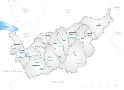
Valais is divided into 13 districts, with the district of Raron being further divided into two half-districts. The districts are listed here in geographical order:
Upper Valais:
- Goms with capital Münster-Geschinen
- Östlich Raron (half-district) with capital Mörel-Filet
- Brig with capital Brig-Glis
- Visp with capital Visp
- Westlich Raron (half-district) with capital Raron
- Leuk with capital Leuk
Central Valais:
- Sierre with capital Sierre
- Hérens with capital Vex
- Sion with capital Sion
- Conthey with capital Conthey
Lower Valais:
- Entremont with capital Sembrancher
- Martigny with capital Martigny
- Saint-Maurice with capital Saint-Maurice
- Monthey with capital Monthey
Municipalities
There are 143 municipalities in the canton (As of 2009).[8]
Demographics
The western part of Valais (Central and Lower Valais) is French-speaking, while the eastern part (Upper Valais) is German-speaking. The language border crosses the Rhône between the towns of Sierre and Salgesch and follows the mountain ridge including Bella Tola, Weisshorn and Dent Blanche. At the 2000 census, 62.8% of the population of Valais spoke French or Arpitan, 28.4% spoke German or Walser German, 2.2% spoke Italian and 6.6% spoke other languages. Only 114 people reported speaking Romansh.[9]
The canton is sparsely populated. Its population (as of 31 December 2019) is 345,525.[2] As of 2007, the population included 57,061 foreigners, or about 19.1% of the total population.[10] The largest towns are the capital Sion (Sitten), Monthey, Sierre, Martigny and Brig-Glis. There is no major city located in the canton. As of 2017, 77% of total population is Roman Catholic, while only 6% are members of Swiss Reformed Church.[11]
Politics
Federal election results
| Percentage of the total vote per party in the canton in the National Council Elections 1971-2015[12] | ||||||||||||||
|---|---|---|---|---|---|---|---|---|---|---|---|---|---|---|
| Party | Ideology | 1971 | 1975 | 1979 | 1983 | 1987 | 1991 | 1995 | 1999 | 2003 | 2007 | 2011 | 2015 | |
| FDP.The Liberalsa | Classical liberalism | 19.3 | 18.9 | 22.7 | 25.2 | 24.6 | 25.9 | 24.2 | 18.8 | 17.1 | 16.0 | 18.8 | 18.1 | |
| CVP/PDC/PPD/PCD | Christian democracy | 61.5 | 59.7 | 58.8 | 57.5 | 58.7 | 54.3 | 54.8 | 51.4 | 47.9 | 44.9 | 39.9 | 39.8 | |
| SP/PS | Social democracy | 15.4 | 17.4 | 11.6 | 14.1 | 14.5 | 14.5 | 16.6 | 16.9 | 19.1 | 14.7 | 14.6 | 13.3 | |
| SVP/UDC | Swiss nationalism | * b | * | * | * | * | * | * | 9.0 | 13.4 | 16.6 | 19.7 | 22.1 | |
| LPS/PLS | Swiss liberalism | * | * | 0.8 | * | * | 3.9 | 2.2 | 1.8 | * | 1.0 | * | * | |
| CSP/PCS | Christian left | * | * | * | * | * | * | * | * | * | 1.1 | 0.7 | 1.4 | |
| BDP/PBD | Conservatism | * | * | * | * | * | * | * | * | * | * | 0.6 | * | |
| PdA/PST-POP/PC/PSL | Socialism | * | * | * | * | * | * | 0.9 | * | * | * | * | * | |
| GPS/PES | Green politics | * | * | * | * | 1.7 | 1.3 | 1.3 | 2.1 | 2.6 | 3.9 | 5.0 | 4.9 | |
| Other | 3.8 | 4.0 | 6.2 | 3.2 | 0.6 | * | * | * | * | 1.8 | 0.6 | 0.4 | ||
| Voter participation % | 67.2 | 66.6 | 65.7 | 65.3 | 59.6 | 60.3 | 55.0 | 52.7 | 53.6 | 59.8 | 61.8 | 59.8 | ||
Economy
Primary sector
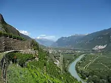
Wines and fruit brandies, e.g. "Williamine" are some of the main production of the canton. Agriculture is often irrigated, notably through small open-air canals bringing the water from the glaciers above. These are called bisses in French and Suonen in German. They also constitute popular hiking routes because of their low declivity. Vineyards are grown on terraces, typically on the south-facing slopes overlooking the Rhône Valley. The wine industry of the canton is the largest in Switzerland.[13] There are also a large number orchards in the area, and saffron is also gathered here.
Agriculture in Valais also consists of cattle breeding in the mountains and dairy farming in the plains. The canton is notable for its cheese and dried meat production. The Hérens cattle is also used in organised cow fights.
Secondary sector
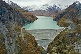
Europe's tallest gravity dam is located at Grande Dixence in the canton, closely followed by the Mauvoisin Dam. Hydroelectric power plants from the canton produce about a quarter of Swiss electricity.
The west part and the most industrial region of the canton is called Chablais. The area is very important for the economy. The lands from Lake Geneva to the town of St-Maurice are located in the Chablais. There are a lot of factories, the most important are the subsidiaries of Novartis and Syngenta, in Monthey. In the town of Collombey-Muraz, there is an oil refinery.
The Lonza Group has large factories in Visp. Near Visp there is a large aluminium processing plant. Other metal products and chemicals are produced around Visp and Sierre, including Swiss Diamond International aluminum cookware.
Tertiary sector
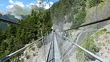
Valais has a long touristic tradition. Hoteliers were at the base of the development of Valais Tourism. Many of them, such as César Ritz, spent time and money to satisfy a clientele from around the world. The canton is nowadays a year-round destination, renowned for its wild landscapes and numerous tourist facilities. In winter, skiing and other snow-related sports are the most popular activities. In summer, hiking and trekking are particularly popular. Climbing and mountaineering can be practised year-round, with most highest mountains of western Europe surrounding Valais. Many of the huts owned by the Swiss Alpine Club are located in the canton.
Valais counts more than 120 winter and summer destinations, including:
- Goms (district): Fiesch-Eggishorn, Bellwald, Binn, Ernen, Obergoms, Oberwald
- Aletsch (UNESCO World Heritage): Bettmeralp, Fiescheralp, Riederalp
- Brig-Glis and surrounding area: Blatten, Belalp, Mund, Termen, Birgisch
- Visp and surrounding area: Visperterminen, Bürchen, Eischoll, Stalden, Törbel, Unterbäch
- Zermatt with Matterhorn and the largest summer ski area of Switzerland, on the southern slopes of Breithorn reachable from the cable car station of the Klein Matterhorn
- Saas Valley: Saas-Fee, Saas-Almagell, Saas-Grund with Fee Glacier, the second largest ski area of was in Switzerland
- Leukerbad
- Sierre, Salquenen and Anniviers, Chandolin, St. Luc, Grimentz, Vercorin, Zinal
- Crans-Montana
- Sion and surrounding area: Anzère, Val d'Hérens, Arolla, Euseigne, Evolène, Hérémence, Mase, Saint-Martin
- 4 Vallées ski area: Nendaz, Verbier, Veysonnaz, Thyon-Les Collons, Mayens-de-Riddes/La Tzoumaz
- Chablais and Portes du Soleil, Champéry, Champoussin, Morgins, Les Crosets, Torgon, Val-d'Illiez, Le Bouveret, Saint-Maurice, Monthey, Evionnaz, St. Gingolph
- St. Bernard Region: Les Marécottes, Bruson, La Fouly, Champex, Vichères-Liddes
The Matterhorn near Zermatt is one of the biggest tourist attractions in the Swiss mountains, as is its sister valley immediately east Saas Fee. Other parts of the mountains of the canton further west are popular as well, such as the more French-speaking resorts near Verbier and the Evolene and Arolla region. The resorts on the north side of the main Rhône valley are popular, looking out southwards towards the Peninne Alps and still part of the southern slope of the Bernese Alps, such as the family-oriented resort of Crans-Montana. The resorts in the Goms (district) are slightly less known, yet also receive attention during the summer hiking season and the winter ski season.
 Hikers on the bisse de Savièse |
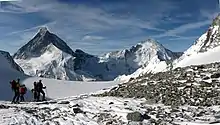
 Skiers above Verbier |
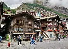 Tourists strolling the streets of Zermatt |
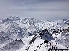
 Ski mountaineers resting in front of the Matterhorn and Dent d'Hérens |
Transport
The only natural low-elevation access to Valais is via the banks of Lake Geneva, which have several railways and highways leading towards Martigny, Sion and the rest of the canton. The major axis is on the north side of the lake and passes via Lausanne and Vevey in the canton of Vaud. From there runs the A9 motorway and the Simplon Railway, ultimately leading to Italy via the Simplon Pass and Simplon Tunnel respectively. On the south side of Lake Geneva, from the French border, is only a highway and the historical Tonkin Railway, now operating in Valais only.
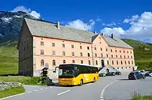
The canton is entirely surrounded by high mountains, but some major mountain passes connect it with the rest of Europe. The main road passes are those of the Grimsel (towards the canton of Bern and the Swiss Plateau), the Furka (Uri), the Nufenen (Ticino), the Simplon and the Great St. Bernard (Italy), and the Forclaz and the Morgins (France). Also notable are the historical and pedestrian passes of the Sanetsch, Rawil, Gemmi and the Lötschberg, connecting Valais with the Swiss Plateau.
The Lötschberg, together with the Simplon, is one of the main north-south axis of Switzerland. The historical Lötschberg Railway opened in 1903. It connects directly Brig to the Swiss Plateau across the Bernese Alps, via Spiez in the canton of Bern, through the high-elevation Lötschberg Tunnel. In 2007, the importance of that axis was further increased with the opening of the low-elevation Lötschberg Base Tunnel, the first high-speed railway connecting Valais to Bern, following essentially the same route, but at the level of the plains. The Lötschberg Base Tunnel was the longest land tunnel in the world when opened. The summit railway, through the historical tunnel, is still used for regional traffic and car transportation across the Lötschberg. The old train line is popular for its highly scenic sections in both cantons on either side of the old tunnel.
An other railway axis connects Valais with central and eastern Switzerland. This is a metre-gauge railway owned by the Matterhorn Gotthard Bahn, which ultimately leads to Disentis and Chur, from Zermatt via Visp and Brig. The main railway goes through the Furka Base Tunnel in the extreme east of the canton, with the older Furka Summit Tunnel being popular for its highly scenic sections as well. The Glacier Express connects directly Zermatt with St. Moritz, using both Mattherhorn Gotthard Bahn and Rhaetian Railway network.
The canton comprehends a very extensive road network, with elevations ranging from that of Lake Geneva at Le Bouveret to that of the Nufenen Pass, the highest paved road in Valais. The A9, the only motorway, serves the valley up to Sierre, the extension towards Brig being currently built. All inhabited side valleys are accessible to motorized transports since the 1960s; the high-elevation reservoirs built during those years, notably the Grande Dixence, necessitating paved roads as well. As in most other cantons, localities are essentially served by PostBus Switzerland, which also operates numerous tourist lines on the Alpine passes and to the high-elevation lakes. Martigny, Sion, Sierre and Brig are hubs of public transportation. The winding mountain roads of Valais are very popular with drivers, bikers and cyclists for their spectacular scenery and are the highlights of competitions such as Tour de Suisse and the Rallye International du Valais. For a list of high-elevation paved roads, see list of highest paved roads in Switzerland.
Because of the tourism there are many railways and cable cars in the mountains. Railways serving side valleys are: the Aigle–Ollon–Monthey–Champéry railway, the Martigny–Orsières Railway (notably serving Verbier), the Martigny–Châtelard Railway (serving the Trient Valley) and the Visp-Zermatt railway. Above Zermatt, the Gornergrat Railway and the Klein Matterhorn cable car are respectively the highest open-air railway and highest public transport in Europe.
In Valais are two ports on Lake Geneva served by the CGN: St. Gingolph and Le Bouveret. The largest airport is located at Sion.
Notes and references
- Arealstatistik Land Cover - Kantone und Grossregionen nach 6 Hauptbereichen accessed 27 October 2017
- "Ständige und nichtständige Wohnbevölkerung nach institutionellen Gliederungen, Geburtsort und Staatsangehörigkeit". bfs.admin.ch (in German). Swiss Federal Statistical Office - STAT-TAB. 31 December 2019. Retrieved 6 October 2020.
- In other official Swiss languages outside Valais: Italian: (Canton) Vallese [valˈleːze, -eːse]; Romansh: (Chantun) Vallais)
-
 One or more of the preceding sentences incorporates text from a publication now in the public domain: Chisholm, Hugh, ed. (1911). "Valais". Encyclopædia Britannica (11th ed.). Cambridge University Press.
 - Raron Affair in German, French and Italian in the online Historical Dictionary of Switzerland.
- Valais in German, French and Italian in the online Historical Dictionary of Switzerland.
- Swisstopo topographic maps
- "Liste officielle des communes de la Suisse - 01.01.2008". Office fédéral de la statistique. Archived from the original on 12 June 2009. Retrieved 15 December 2008.
- Georges Lüdi, Iwar Werlen (Hrsg.):Sprachlandschaft in der Schweiz. Bundesamt für Statistik, Neuchâtel, April 2005.
- Federal Department of Statistics (2008). "Ständige Wohnbevölkerung nach Staatsangehörigkeit, Geschlecht und Kantonen". Archived from the original (Microsoft Excel) on 2008-12-15. Retrieved November 5, 2008.
- "Kirchenmitgliedschaft in der römisch-katholischen und evangelisch-reformierten Kirche nach Kantonen (2017)" (Table 1.4 on the lower part of the page) (in German). SPI St. Gallen. 2018. Retrieved 2019-02-22.
- Nationalratswahlen: Stärke der Parteien nach Kantonen (Schweiz = 100%) (Report). Swiss Federal Statistical Office. 2015. Archived from the original on 2016-08-02. Retrieved 2016-08-08.
- Valais Wine wine-searcher.com
External links
| Wikimedia Commons has media related to Canton of Valais. |
| Wikivoyage has a travel guide for Valais. |
- Cantonal government (in French and German)
- Official information from Valais/Wallis Promotion
- Official statistics
| Authority control |
|---|