Grez-Doiceau
Grez-Doiceau is a Belgian municipality located in the province of Walloon Brabant. On January 1, 2006, Grez-Doiceau had a total population of 12,403. The total area is 55.44 km² which gives a population density of 224 inhabitants per km². Grez-Doiceau is watered by the Train, a tributary of the Dyle.
Grez-Doiceau
| |
|---|---|
.jpg.webp) | |
 Flag | |
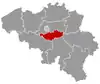
 Grez-Doiceau Location in Belgium
The municipality of Grez-Doiceau in Walloon Brabant 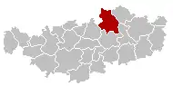 | |
| Coordinates: 50°44′N 04°42′E | |
| Country | Belgium |
| Community | French Community |
| Region | Wallonia |
| Province | Walloon Brabant |
| Arrondissement | Nivelles |
| Government | |
| • Mayor | De Coster Bauchau Sybille (A.C.) |
| • Governing party/ies | Alliance Communale - Equipe– |
| Area | |
| • Total | 55.44 km2 (21.41 sq mi) |
| Population (2018-01-01)[1] | |
| • Total | 13,368 |
| • Density | 240/km2 (620/sq mi) |
| Postal codes | 1390 |
| Area codes | 010 |
| Website | www.grez-doiceau.be |
The municipality consists of the following sub-municipalities: Archennes (Eerken), Biez, Bossut-Gottechain, Grez-Doiceau proper, and Nethen.
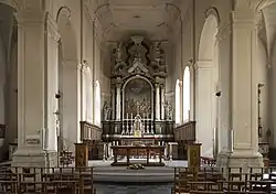
Altar of Saint George's church, Grez-Doiceau
References
- "Wettelijke Bevolking per gemeente op 1 januari 2018". Statbel. Retrieved 9 March 2019.
External links
 Media related to Grez-Doiceau at Wikimedia Commons
Places adjacent to Grez-Doiceau | ||||||||||
|---|---|---|---|---|---|---|---|---|---|---|
| ||||||||||
This article is issued from Wikipedia. The text is licensed under Creative Commons - Attribution - Sharealike. Additional terms may apply for the media files.
