Guarizama
Guarizama is a municipality in the Honduran department of Olancho.
Guarizama | |
|---|---|
Municipality | |
 Guarizama | |
| Coordinates: 14°55′N 86°20′W | |
| Country | |
| Department | Olancho |
| Villages | 5 |
| Municipality since | 1901 |
| Area | |
| • Total | 16.91 km2 (6.53 sq mi) |
| Population (2015) | |
| • Total | 7,852 |
| • Density | 460/km2 (1,200/sq mi) |
| Climate | Aw |
Its name comes from Quanhilzamatil, tight amate tree, probably in the place had that tree.[1]
Historical data
In the population census of 1887 listed as Manto Village in 1901 was given municipality status.
Villages
The municipality has the following five villages: National Institute of Statistics, Honduras. (Census 2001)
- Guarizama
- El Zapotal
- La Carta
- El Rodeo
- Trinidad
References
Capital: Juticalpa | ||
| Municipalities | 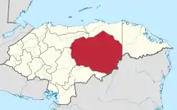 | |
This article is issued from Wikipedia. The text is licensed under Creative Commons - Attribution - Sharealike. Additional terms may apply for the media files.