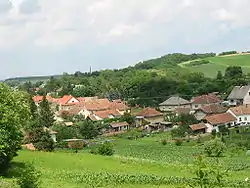
Gutorfölde
Gutorfölde is a village in Zala County, Hungary.[2]
Gutorfölde | |
|---|---|
Village | |
 | |
 Flag  Coat of arms | |
 Gutorfölde Location of Gutorfölde | |
| Coordinates: 46.642748°N 16.736684°E | |
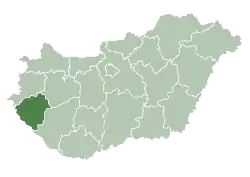
| Country | Hungary |
| Region | Western Transdanubia |
| County | Zala |
| District | Zalaegerszeg |
| Area | |
| • Total | 24.85 km2 (9.59 sq mi) |
| Population (1 January 2015)[1] | |
| • Total | 985 |
| • Density | 40/km2 (100/sq mi) |
| Time zone | UTC+1 (CET) |
| • Summer (DST) | UTC+2 (CEST) |
| Postal code | 8951 |
| Area code | (+36) 92 |
| Website | www |
References
- "Gazetteer of Hungary, 1st January 2015" (in Hungarian). Hungarian Central Statistical Office. 3 September 2015. Retrieved 4 September 2015.
- Hungarian Central Statistical Office
.svg.png.webp)
This article is issued from Wikipedia. The text is licensed under Creative Commons - Attribution - Sharealike. Additional terms may apply for the media files.