Hātea River
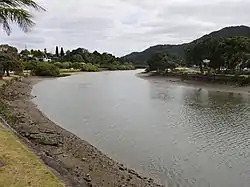
The Hātea River is a river of New Zealand. It flows from the north-east of Whangarei southwards and into the northern head of Whangarei Harbour.[1] Its lower length forms the eastern boundary of the city. The banks along the lower reaches are parks and bushland[2] with a series of metalled walks suitable for all weathers.[3]
| Hātea River | |
|---|---|
 | |
| Location | |
| Country | New Zealand |
| Physical characteristics | |
| Source | |
| • location | Whangarei District |
| Mouth | |
• location | Whangarei Harbour |
At Whangarei Falls near Tikipunga, the Hātea River drops 26 metres (85 ft) over a basalt lava flow. The falls, originally known as Otuihau, have been a picnic spot since at least the 1890s.[4]
The spelling of the river's name was amended from Hatea to Hātea by the New Zealand Geographic Board in 2007.[5]
See also
References
- Peter Dowling (editor) (2004). Reed New Zealand Atlas. Reed Books. pp. map 7. ISBN 0-7900-0952-8.CS1 maint: extra text: authors list (link)
- Discover New Zealand:A Wises Guide (9th ed.). 1994. p. 19.
- "Hatea River Walks". Whangarei District Council. Retrieved 11 July 2009.
- Parkes, W. F. (1992). Guide to Whangarei City and District. p. 11. ISBN 0-473-01639-7.
- "Land Information New Zealand. Decisions of the New Zealand Geographic Land Board". Archived from the original on 22 May 2010. Retrieved 5 April 2010.
- Land Information New Zealand - Search for Place Names
This article is issued from Wikipedia. The text is licensed under Creative Commons - Attribution - Sharealike. Additional terms may apply for the media files.