Tikipunga
Tikipunga is one of the biggest suburbs in Whangārei, New Zealand. It is in the north-east part of the town and has the landmark Whangārei Falls nearby.
Tikipunga | |
|---|---|
Suburb | |
 | |
| Country | New Zealand |
| Local authority | Whangarei District Council |
| Population (2018) | |
| • Total | 6,906 |
| Kauri | Glenbervie | |
| Kamo |
|
|
| Whau Valley | Otangarei |
Demographics
| Year | Pop. | ±% p.a. |
|---|---|---|
| 2006 | 5,763 | — |
| 2013 | 5,484 | −0.71% |
| 2018 | 6,906 | +4.72% |
| Source: [1] | ||
Tikipunga (comprising the statistical areas of Tikipunga North and Tikipunga South) had a population of 6,906 at the 2018 New Zealand census, an increase of 1,422 people (25.9%) since the 2013 census, and an increase of 1,143 people (19.8%) since the 2006 census. There were 2,433 households. There were 3,213 males and 3,693 females, giving a sex ratio of 0.87 males per female. Of the total population, 1,662 people (24.1%) were aged up to 15 years, 1,296 (18.8%) were 15 to 29, 2,496 (36.1%) were 30 to 64, and 1,452 (21.0%) were 65 or older. Figures may not add up to the total due to rounding.
Ethnicities were 69.8% European/Pākehā, 41.8% Māori, 6.3% Pacific peoples, 3.3% Asian, and 1.6% other ethnicities. People may identify with more than one ethnicity.
The percentage of people born overseas was 12.9, compared with 27.1% nationally.
Although some people objected to giving their religion, 48.4% had no religion, 36.9% were Christian, and 6.5% had other religions.
Of those at least 15 years old, 522 (10.0%) people had a bachelor or higher degree, and 1,416 (27.0%) people had no formal qualifications. The employment status of those at least 15 was that 2,118 (40.4%) people were employed full-time, 606 (11.6%) were part-time, and 315 (6.0%) were unemployed.[1]
Attractions
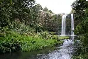
The nearby Whangārei Falls have since the 1940s been in public ownership.[2]
Education
Tikipunga High School is a state coeducational Year 7-13 secondary school on Corks Road, with a roll of 298 students as of March 2020.[3][4] The school opened in 1971.
Tikipunga Primary School is a contributing primary (years 1–6) school with a roll of 249 students as of March 2020.[3][5]
Te Kura Kaupapa Maori o Te Rawhiti Roa is a composite (years 1–15) school with a roll of 186 students as of March 2020.[3][6]
All these schools are coeducational.
.jpg.webp) Whangarei Falls as seen from a walkway over the river.
Whangarei Falls as seen from a walkway over the river.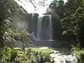 Falls from below.
Amenities
The Paramount Plaza shopping centre on Paramount Parade serves the suburb and is anchored by a large Countdown Supermarket. It contains a service station, several food outlets, a liquor store, a pharmacy, a video store and a medical centre. Nearby the plaza is the Tikipunga branch of the Whangārei Libraries. There is also a smaller suburban shopping strip on the corner of Kiripaka and Spedding roads.
Notes
- "Statistical area 1 dataset for 2018 Census". Statistics New Zealand. March 2020. Tikipunga North (106200) and Tikipunga South (106500). 2018 Census place summary: Tikipunga North 2018 Census place summary: Tikipunga South
- Parkes, W. F. (1992). Guide to Whangarei City and District. p. 11. ISBN 0-473-01639-7.
- "New Zealand Schools Directory". New Zealand Ministry of Education. Retrieved 26 April 2020.
- Education Counts: Tikipunga High School
- Education Counts: Tikipunga Primary School
- Education Counts: Te Kura Kaupapa Maori o Te Rawhiti Roa
