Haast River
The Haast River / Awarua is a river on the West Coast of the South Island of New Zealand.

| Haast River | |
|---|---|
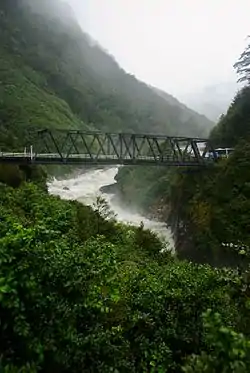 Gates of Haast Bridge in the mountains | |
| Location | |
| Country | New Zealand |
| Physical characteristics | |
| Source | |
| • location | Southern Alps |
| Mouth | |
• location | Tasman Sea |
| Length | 100 km (62 mi) |
The Haast River drains the western watershed of the Haast Pass. It is 100 kilometres (62 mi) in length, and enters the Tasman Sea near Haast township. The river's main tributary is the Landsborough River.
The grassy flats on the lower reaches are grazed by cattle owned by the local farmers. Tourism operators offer jetboat tours on the river.
The river often has glacial silt in suspension in the water from glaciers in the Southern Alps. The majority of the surrounding land is publicly owned and administered by the Department of Conservation. It is set within the Te Wahipounamu World Heritage site.

State Highway 6 follows virtually the complete length of the river. From near Haast Pass, the state highway is located on the river's true left. It switches to the true right at the Gates of Haast Bridge. At Pleasant Flat, where the valley widens out, the state highway crosses back to the true left.[1] The final bridge is near the coast, just after the turnoff to the Haast township. At 737 metres (2,418 ft) it is the longest one-lane road bridge in New Zealand, and the 7th longest New Zealand bridge overall.[2]
The river is named after Julius von Haast. Together with four others, von Haast explored a route from Otago to the West Coast that was long known to Maori; the others were William Young (a surveyor), Charles Håring (a retired sailor), William Francis Warner (later the proprietor of Warner's Hotel), and Robert Langley Holmes (later the Canterbury provincial meteorologist). They set out on 22 January 1863 and stood in the surf on 20 February.[3] The Maori name for the river is Awarua.
References
- "NZ Topo Map". topomap.co.nz. Retrieved 5 January 2020.
- "Transit New Zealand Frequently Asked Questions". Archived from the original on 19 June 2008. Retrieved 23 September 2008.
- Holm, Janet (2005). Caught mapping: the life and times of New Zealand's early surveyors. Christchurch: Hazard Press. pp. 165–169. OCLC 636380050.
External links
 Media related to Haast River at Wikimedia Commons