Haast, New Zealand
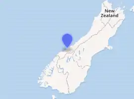
Haast is a small town in the Westland District territorial authority on the West Coast of New Zealand's South Island. The Haast region covers over 2,500 square kilometres (970 sq mi).[1]
Haast | |
|---|---|
 | |
| |
| Coordinates: 43°52′52″S 169°2′32″E | |
| Country | New Zealand |
| Region | West Coast |
| District | Westland District |
| Electorates | West Coast-Tasman Te Tai Tonga |
| Population (2018) | |
| • Total | 84 |
| Time zone | UTC+12 (NZST) |
| • Summer (DST) | UTC+13 (NZDT) |
| Postcode | 7886 |
| Area code(s) | 03 |
| Local iwi | Ngāi Tahu |
The region is named after Julius von Haast, a Prussian-born geologist instrumental in the early geological surveys of New Zealand.
The main economic activities in the Haast region are farming, fishing and tourism.
Lake Moeraki is 30 kilometres (19 mi) to the northeast, and the Haast Pass is 63 kilometres (39 mi) to the southeast by road. State Highway 6 passes through Haast Junction and just to the east of Haast township. The settlement of Okuru is located on the coast 12 kilometres (7.5 mi) south-west of Haast.[2][3]
The rarest subspecies of kiwi, the Haast tokoeka, is only found in the mountains of the Haast region.
History
European settlement of the area dates back to the 1870s. The remoteness of the area initially limited access to seagoing vessels, with some rough tracks from the north and east.
The present Haast township was originally a New Zealand Ministry of Works road construction camp, which expanded into a permanent township when the opening of the Haast Pass in 1962 made the region more accessible.[4] The road through the pass to Wanaka was upgraded in 1966.[5]
In 1990 the Haast area was included as part of a UNESCO World Heritage Site, giving international recognition as a location of significant natural value to Te Wahipounamu - The South West New Zealand World Heritage Area.[6]
Demographics
| Year | Pop. | ±% p.a. |
|---|---|---|
| 2006 | 300 | — |
| 2013 | 240 | −3.14% |
| 2018 | 258 | +1.46% |
| Source: [7] | ||
The Haast statistical area, which at 4,099 km2 (1,583 sq mi) is much larger than the town, had a population of 258 at the 2018 New Zealand census, an increase of 18 people (7.5%) since the 2013 census, and a decrease of 42 people (-14.0%) since the 2006 census. There were 144 households. There were 132 males and 123 females, giving a sex ratio of 1.07 males per female. The median age was 52.6 years (compared with 37.4 years nationally), with 24 people (9.3%) aged under 15 years, 36 (14.0%) aged 15 to 29, 138 (53.5%) aged 30 to 64, and 57 (22.1%) aged 65 or older.
Ethnicities were 86.0% European/Pākehā, 11.6% Māori, 4.7% Pacific peoples, 4.7% Asian, and 3.5% other ethnicities (totals add to more than 100% since people could identify with multiple ethnicities).
The proportion of people born overseas was 18.6%, compared with 27.1% nationally.
Although some people objected to giving their religion, 46.5% had no religion, 39.5% were Christian, 1.2% were Buddhist and 1.2% had other religions.
Of those at least 15 years old, 27 (11.5%) people had a bachelor or higher degree, and 51 (21.8%) people had no formal qualifications. The median income was $27,000, compared with $31,800 nationally. The employment status of those at least 15 was that 147 (62.8%) people were employed full-time, 27 (11.5%) were part-time, and 3 (1.3%) were unemployed.[7]
The population of Haast township was 84 in the 2018 census, an increase of 30 from 2013. There were 42 males and 39 females. 89% of people identified as European/Pākehā and 14% as Māori.[8]
Climate
| Climate data for Haast | |||||||||||||
|---|---|---|---|---|---|---|---|---|---|---|---|---|---|
| Month | Jan | Feb | Mar | Apr | May | Jun | Jul | Aug | Sep | Oct | Nov | Dec | Year |
| Average high °C (°F) | 19 (66) |
19 (66) |
18 (65) |
16 (61) |
14 (57) |
12 (53) |
12 (53) |
12 (54) |
14 (57) |
15 (59) |
16 (61) |
18 (64) |
16 (60) |
| Average low °C (°F) | 10 (50) |
11 (51) |
10 (50) |
8 (47) |
6 (43) |
3 (38) |
3 (37) |
4 (39) |
5 (41) |
7 (44) |
8 (47) |
10 (50) |
7 (45) |
| Average precipitation mm (inches) | 310 (12.4) |
290 (11.4) |
330 (12.8) |
350 (13.8) |
290 (11.6) |
230 (9.1) |
210 (8.3) |
320 (12.5) |
290 (11.5) |
360 (14.1) |
330 (12.9) |
330 (12.8) |
3,640 (143.2) |
| Source: Weatherbase [9] | |||||||||||||
Communities
Haast Junction is located on the southwest bank of the Haast River, immediately south of the Haast Bridge, at the junction of State Highway 6 and the Haast–Jackson Bay Road.
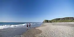
The smaller Haast Beach is on the coast of the Tasman Sea, approximately 4 kilometres (2.5 mi) west southwest of Haast Junction, on the Haast–Jackson Bay Road.
The larger Haast township is located on the Haast River, approximately 3 kilometres (2 mi) south of Haast Junction, on State Highway 6. The New Zealand Department of Conservation operates a visitor centre in Haast Junction, offering a wide range of information about the surrounding area.
Infrastructure
The Haast area is not connected to the national electricity grid. New Zealand Energy operates a distribution network supplying the town. Electricity is generated by a 800-kilowatt hydroelectric scheme on the Turnbull River, backed up by a 375-kilowatt diesel generator.[10]
Haast received mobile coverage in May 2018. 3G mobile coverage is provided for all three mobile networks within a 3 km (2 mi) radius of Haast township.[11]
Education
The Haast School is a coeducational full primary (years 1–8) school with a student roll of 7 as of March 2020.[12][13] The school opened in the 1890s[14] and is the most isolated school in the mainland of New Zealand.[15]
There are no secondary schools in the Haast area. The nearest secondary school is Mount Aspiring College, 140 kilometres (85 mi) away over the Haast Pass in Wanaka, which is too far away to be practical. Most secondary students instead board at secondary schools in Alexandra, Oamaru or Dunedin.
See also
References
- "West Coast - Haast". New Zealand Tourism Guide. Retrieved 2011-02-22.
- Peter Dowling (editor) (2004). Reed New Zealand Atlas. Reed Books. map 78. ISBN 0-7900-0952-8.CS1 maint: extra text: authors list (link)
- Roger Smith, GeographX (2005). The Geographic Atlas of New Zealand. Robbie Burton. map 180. ISBN 1-877333-20-4.
- "About Westland, District Maps, Haast". Westland District Council. Archived from the original on 2011-07-17. Retrieved 2011-02-22.
- A Wheel on Each Corner, The History of the IPENZ Transportation Group 1956-2006 - Douglass, Malcolm; IPENZ Transportation Group, 2006, Page 12
- "Te Wahipounamu – South West New Zealand, Description". UNESCO World Heritage Centre. Retrieved 2011-02-22.
- "Statistical area 1 dataset for 2018 Census". Statistics New Zealand. March 2020. Haast (311200). 2018 Census place summary: Haast
- "Age and sex by ethnic group (grouped total response), for census usually resident population counts, 2006, 2013, and 2018 Censuses (urban rural areas)". Statistics New Zealand. Retrieved 19 December 2020.
- "Weatherbase: Historical Weather for Haast, New Zealand". Weatherbase. 2011. Retrieved on November 24, 2011.
- "West Coast Lifelines Vulnerability and Interdependency Assessment - Supplement 8 Energy Lifelines Assets" (PDF). West Coast Civil Defence Emergency Management Group. August 2017.
- "Haast cellphone coverage by end of May: Curran". Otago Daily Times. 7 March 2018.
- "New Zealand Schools Directory". New Zealand Ministry of Education. Retrieved 26 April 2020.
- Education Counts: Haast School
- "Westland Board of Education". West Coast Times. 16 March 1891. p. 4.
- Harris, Sarah (16 January 2018). "A blast from the Haast - NZ's most isolated town". New Zealand Herald.
External links
| Wikivoyage has a travel guide for Haast. |
- Haast at the Department of Conservation
- Haast Promotions Group