Hallein District
The Bezirk Hallein is an administrative district (Bezirk) in the federal state of Salzburg, Austria, and congruent with the Tennengau region.
Hallein District
Bezirk Hallein | |
|---|---|

| |
| Country | Austria |
| State | Salzburg |
| Number of municipalities | 13 |
| Area | |
| • Total | 668.31 km2 (258.04 sq mi) |
| Population (2001) | |
| • Total | 54,282 |
| • Density | 81/km2 (210/sq mi) |
| Time zone | UTC+01:00 (CET) |
| • Summer (DST) | UTC+02:00 (CEST) |
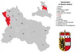
District map divided per municipalities (click to enlarge)
| Year | Pop. | ±% |
|---|---|---|
| 1869 | 18,674 | — |
| 1880 | 19,219 | +2.9% |
| 1890 | 19,983 | +4.0% |
| 1900 | 22,398 | +12.1% |
| 1910 | 24,600 | +9.8% |
| 1923 | 24,627 | +0.1% |
| 1934 | 26,988 | +9.6% |
| 1939 | 27,094 | +0.4% |
| 1951 | 34,263 | +26.5% |
| 1961 | 35,637 | +4.0% |
| 1971 | 41,115 | +15.4% |
| 1981 | 44,815 | +9.0% |
| 1991 | 50,396 | +12.5% |
| 2001 | 54,282 | +7.7% |
| Source: Statistik Austria | ||
Area of the district is 668.31 km², with a population of 54,282 (May 15, 2001), and population density 81 persons per km². Administrative center of the district is Hallein.
Administrative divisions
The district is divided into 13 municipalities, one of them is a town, and four of them are market towns.
Towns
- Hallein (18,399)
Market towns
- Abtenau (3,324)
- Golling an der Salzach (3,903)
- Kuchl (6,431)
- Oberalm (3,844)
Municipalities
- Adnet (3,324)
- Annaberg-Lungötz (2,296)
- Bad Vigaun (1,885)
- Krispl (849)
- Puch bei Hallein (4,088)
- Rußbach am Paß Gschütt (803)
- Sankt Koloman (1,497)
- Scheffau am Tennengebirge (1,292)
(population numbers May 15, 2001)
External links
![]() Media related to Hallein District at Wikimedia Commons
Media related to Hallein District at Wikimedia Commons
| Cities |  | |
|---|---|---|
| Districts | ||
| Authority control |
|
|---|
This article is issued from Wikipedia. The text is licensed under Creative Commons - Attribution - Sharealike. Additional terms may apply for the media files.