Happurg
Happurg is a municipality in the district of Nürnberger Land in Bavaria in Germany. During World War II, a subcamp of Flossenbürg concentration camp was located here.[2]
Happurg | |
|---|---|
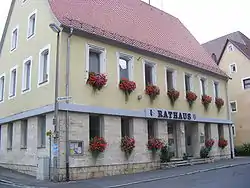 Town hall | |
 Coat of arms | |
Location of Happurg within Nürnberger Land district 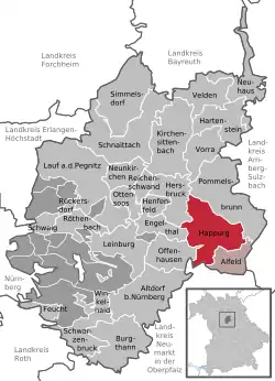 | |
 Happurg  Happurg | |
| Coordinates: 49°29′35″N 11°28′16″E | |
| Country | Germany |
| State | Bavaria |
| Admin. region | Mittelfranken |
| District | Nürnberger Land |
| Municipal assoc. | Happurg |
| Subdivisions | 14 Gemeindeteile |
| Government | |
| • Mayor | Bernd Bogner (FW) |
| Area | |
| • Total | 42.59 km2 (16.44 sq mi) |
| Elevation | 353 m (1,158 ft) |
| Population (2019-12-31)[1] | |
| • Total | 3,766 |
| • Density | 88/km2 (230/sq mi) |
| Time zone | UTC+01:00 (CET) |
| • Summer (DST) | UTC+02:00 (CEST) |
| Postal codes | 91230 |
| Dialling codes | 09151 |
| Vehicle registration | LAU, ESB, HEB, N, PEG |
| Website | www.happurg.de |
Geography
Neighboring municipalities
Neighboring municipalities and communities (to the north going clockwise) are: Pommelsbrunn, Alfeld, Lauterhofen, Offenhausen, Engelthal, and Hersbruck.
Geographic location
The municipality lies in the eastern part of the Franconian Jura
References
- "Tabellenblatt "Daten 2", Statistischer Bericht A1200C 202041 Einwohnerzahlen der Gemeinden, Kreise und Regierungsbezirke". Bayerisches Landesamt für Statistik und Datenverarbeitung (in German). July 2020.
- Christine O'Keefe. Concentration Camps
| Authority control |
|---|
This article is issued from Wikipedia. The text is licensed under Creative Commons - Attribution - Sharealike. Additional terms may apply for the media files.
