Harrietta, Michigan
Harrietta is a village in Wexford County of the U.S. state of Michigan. Harrietta has a population of 143 at the 2010 census, making it the least populous village in Northern Michigan. The village is on the boundary between Slagle Township on the west and Boon Township on the east, with about half of the village in each.
Harrietta, Michigan | |
|---|---|
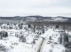 Harrietta in December 2017 | |
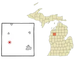 Location of Harrietta, Michigan | |
| Coordinates: 44°18′30″N 85°41′57″W | |
| Country | United States |
| State | Michigan |
| County | Wexford |
| Area | |
| • Total | 0.99 sq mi (2.57 km2) |
| • Land | 0.99 sq mi (2.57 km2) |
| • Water | 0.00 sq mi (0.00 km2) |
| Elevation | 1,145 ft (349 m) |
| Population | |
| • Total | 143 |
| • Estimate (2019)[3] | 146 |
| • Density | 147.03/sq mi (56.78/km2) |
| Time zone | UTC-5 (Eastern (EST)) |
| • Summer (DST) | UTC-4 (EDT) |
| ZIP code | 49638 |
| Area code(s) | 231 |
| FIPS code | 26-36720[4] |
| GNIS feature ID | 1620134[5] |
Harrietta was first platted by James M. Ashley in 1889. It was incorporated as a village in 1891 with the name of Gaston. It was named Hariette in 1892 and the present spelling was adopted in 1923.[6] Harrietta is a combination of the names of a railroad official, Harry, and that of his wife, Henrietta.[7]
Village infrastructure
Davis Ave, the main roadway through the village is lined with historic store fronts and businesses. Despite this, Harrietta has no working business, shops, or active buildings besides the post office and two active church congregations. The village may be considered by some to be a "ghost town", as the village fell into a sharp economic decline at the turn of the century and thus suffered a significant loss in population. The Village Hall serves as a community gathering place for events and services, while a small park across the street provides a space for recreation. Just outside of village limit to the west is the Harrietta State Fish Hatchery, the first of its kind in the state of Michigan. To the south of the village limits is Caberfae Peaks Ski and Golf Resort. Two convenience store gas stations are located a few miles outside of the village at the corner of M-37 and W 30 Rd, and at the corner of M-55 and M-37.
Geography
According to the United States Census Bureau, the village has a total area of 0.93 square miles (2.41 km2), all land.[8]
Demographics
| Historical population | |||
|---|---|---|---|
| Census | Pop. | %± | |
| 1890 | 335 | — | |
| 1900 | 419 | 25.1% | |
| 1910 | 336 | −19.8% | |
| 1920 | 226 | −32.7% | |
| 1930 | 149 | −34.1% | |
| 1940 | 208 | 39.6% | |
| 1950 | 112 | −46.2% | |
| 1960 | 119 | 6.3% | |
| 1970 | 132 | 10.9% | |
| 1980 | 139 | 5.3% | |
| 1990 | 157 | 12.9% | |
| 2000 | 169 | 7.6% | |
| 2010 | 143 | −15.4% | |
| 2019 (est.) | 146 | [3] | 2.1% |
| U.S. Decennial Census[9] | |||
2010 census
As of the census[2] of 2010, there were 143 people, 60 households, and 40 families residing in the village. The population density was 153.8 inhabitants per square mile (59.4/km2). There were 103 housing units at an average density of 110.8 per square mile (42.8/km2). The racial makeup of the village was 94.4% White, 0.7% African American, 0.7% Asian, and 4.2% from two or more races. Hispanic or Latino of any race were 4.2% of the population.
There were 60 households, of which 21.7% had children under the age of 18 living with them, 53.3% were married couples living together, 5.0% had a female householder with no husband present, 8.3% had a male householder with no wife present, and 33.3% were non-families. 26.7% of all households were made up of individuals, and 10% had someone living alone who was 65 years of age or older. The average household size was 2.38 and the average family size was 2.80.
The median age in the village was 46.1 years. 21% of residents were under the age of 18; 4.2% were between the ages of 18 and 24; 23.1% were from 25 to 44; 34.3% were from 45 to 64; and 17.5% were 65 years of age or older. The gender makeup of the village was 53.8% male and 46.2% female.
2000 census
As of the census[4] of 2000, there were 169 people, 63 households, and 43 families residing in the village. The population density was 182.0 per square mile (70.2/km2). There were 93 housing units at an average density of 100.2 per square mile (38.6/km2). The racial makeup of the village was 98.22% White, 0.59% from other races, and 1.18% from two or more races. Hispanic or Latino of any race were 4.73% of the population.
There were 63 households, out of which 27.0% had children under the age of 18 living with them, 54.0% were married couples living together, 12.7% had a female householder with no husband present, and 30.2% were non-families. 23.8% of all households were made up of individuals, and 12.7% had someone living alone who was 65 years of age or older. The average household size was 2.68 and the average family size was 3.18.
In the village, the population was spread out, with 26.6% under the age of 18, 8.3% from 18 to 24, 28.4% from 25 to 44, 20.1% from 45 to 64, and 16.6% who were 65 years of age or older. The median age was 37 years. For every 100 females, there were 96.5 males. For every 100 females age 18 and over, there were 90.8 males.
The median income for a household in the village was $33,500, and the median income for a family was $34,286. Males had a median income of $28,125 versus $31,563 for females. The per capita income for the village was $15,258. About 4.8% of families and 6.9% of the population were below the poverty line, including 5.6% of those under the age of eighteen and none of those sixty-five or over.
References
- "2019 U.S. Gazetteer Files". United States Census Bureau. Retrieved July 25, 2020.
- "U.S. Census website". United States Census Bureau. Retrieved 2012-11-25.
- "Population and Housing Unit Estimates". United States Census Bureau. May 24, 2020. Retrieved May 27, 2020.
- "U.S. Census website". United States Census Bureau. Retrieved 2008-01-31.
- "US Board on Geographic Names". United States Geological Survey. 2007-10-25. Retrieved 2008-01-31.
- Walter Romig, Michigan Place Names, p. 253
- Gannett, Henry (1905). The Origin of Certain Place Names in the United States. Govt. Print. Off. pp. 150.
- "US Gazetteer files 2010". United States Census Bureau. Retrieved 2012-11-25.
- "Census of Population and Housing". Census.gov. Retrieved June 4, 2015.
External links
Municipalities and communities of Wexford County, Michigan, United States | ||
|---|---|---|
| Cities |  Map of Michigan highlighting Wexford County.svg | |
| Villages | ||
| Charter township | ||
| General law townships | ||
| CDPs | ||
| Other unincorporated communities | ||
| ||
