Harvest, Alabama
Harvest is an unincorporated community and census-designated place (CDP) in the northwestern part of Madison County, Alabama, United States, and is included in the Huntsville-Decatur Combined Statistical Area. As of the 2010 census, the population of the community is 5,281.
Harvest, Alabama | |
|---|---|
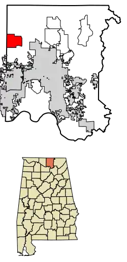 Location of Harvest in Madison County, Alabama. | |
| Coordinates: 34°51′10″N 86°44′52″W | |
| Country | United States |
| State | Alabama |
| County | Madison |
| Area | |
| • Total | 12.40 sq mi (32.11 km2) |
| • Land | 12.33 sq mi (31.94 km2) |
| • Water | 0.06 sq mi (0.16 km2) |
| Elevation | 833 ft (254 m) |
| Population (2010) | |
| • Total | 5,281 |
| • Estimate (2016)[2] | N/A |
| Time zone | UTC-6 (Central (CST)) |
| • Summer (DST) | UTC-5 (CDT) |
| ZIP code | 35749 |
| Area code(s) | 256 |
| FIPS code | 01-33472 |
| GNIS feature ID | 0119829 |
History
In the late 1800s through early 1900s, Harvest saw growth and development due to extension of the Fayetteville, TN rail yard along the existing Nashville, Chattanooga, and St. Louis (NC&StL) Railroad. In the early-mid 1900s Harvest was centered around the railroad, between Capshaw and Toney, presently known as Old Railroad Bed Rd. Many early settlers in the Harvest area were from the Fayetteville, TN. April 20, 1929, the NC&StL Railroad Company sold the property and roadbed running through Madison County to the County Highway Department with a quitclaim deed. Today, the roadbed is marked as a two-lane roadway that continues to serve as a vital link in the modern day-to-day transportation network, and carries the seemingly appropriate name “Old Railroad Bed Road”. Elder members of the Harvest community recall a significant Native American presence in the area, primarily along the railroad areas.
On April 3, 1974, during the 1974 Super Outbreak, two F5 tornadoes struck the community within 30 minutes of each other. Most of Harvest, primarily along the Old Railroad Bed area, along with nearby communities such as Tanner, was destroyed. Fifty people were killed by the tornadoes.
Harvest was hit by another violent tornado on May 18, 1995 that devastated the Anderson Hills subdivision. This tornado killed one person and was rated F4.
On April 27, 2011, during the 2011 Super Outbreak, Harvest suffered significant damage from the EF5 tornado that destroyed Hackleburg and Phil Campbell, primarily north of Nick Davis Road, situated between Old Railroad Bed and Wall Triana. The Anderson Hills subdivision was once again devastated, and damage in Harvest was rated EF4. The tornado killed 72 people along its path.
On March 2, 2012, during the tornado outbreak of March 2–3, 2012, Harvest suffered yet another direct hit from a damaging tornado, this one rated EF3. The tornado hit exactly the same area as the April 27, 2011 tornado, though no fatalities occurred this time. Some of the houses being rebuilt from that outbreak were destroyed again.
Geography
Harvest is located at 34°51′10″N 86°44′53″W (34.852827, -86.748047).[3]
According to the U.S. Census Bureau, the community has a total area of 12.4 square miles (32 km2), all land.
Capshaw Mountain is the only notable geological feature in the area, which extends about 800 feet above the general elevation in the area. The top of this small mountain is the site of several substantial communications towers used by local radio stations. Capshaw Mountain forms a watershed that provides the water supply for the community.
Demographics
| Historical population | |||
|---|---|---|---|
| Census | Pop. | %± | |
| 1990 | 1,922 | — | |
| 2000 | 3,054 | 58.9% | |
| 2010 | 5,281 | 72.9% | |
| U.S. Decennial Census[4] | |||
At the 2000 census there were 3,054 people, 1,092 households, and 898 families living in the community. The population density was 245.8 people per square mile (94.9/km2). There were 1,146 housing units at an average density of 92.2 per square mile (35.6/km2). The racial makeup of the community was 76.56% White, 18.76% Black or African American, 1.28% Native American, 1.11% Asian, 0.20% from other races, and 2.10% from two or more races. 0.98% of the population were Hispanic or Latino of any race.[5] Of the 1,092 households 39.9% had children under the age of 18 living with them, 72.5% were married couples living together, 7.1% had a female householder with no husband present, and 17.7% were non-families. 15.8% of households were one person and 5.0% were one person aged 65 or older. The average household size was 2.80 and the average family size was 3.13.
The age distribution was 28.6% under the age of 18, 5.6% from 18 to 24, 34.3% from 25 to 44, 23.6% from 45 to 64, and 8.0% 65 or older. The median age was 36 years. For every 100 females, there were 102.8 males. For every 100 females age 18 and over, there were 97.5 males.
The median household income was $61,319 and the median family income was $64,519. Males had a median income of $46,813 versus $30,114 for females. The per capita income for the community was $23,322. About 6.8% of families and 8.0% of the population were below the poverty line, including 7.2% of those under age 18 and 4.2% of those age 65 or over.
2010 census
At the 2010 census there were 5,281 people, 1,882 households, and 1,512 families living in the community. The population density was 246.3 people per square mile (94.8/km2). There were 1,976 housing units at an average density of 159.4 per square mile (61.4/km2). The racial makeup of the community was 62.2% White, 31.7% Black or African American, .5% Native American, 1.2% Asian, 1.1% from other races, and 3.2% from two or more races. 3.1% of the population were Hispanic or Latino of any race.[6] Of the 1,882 households 38.9% had children under the age of 18 living with them, 62.8% were married couples living together, 12.6% had a female householder with no husband present, and 19.7% were non-families. 16.4% of households were one person and 4.3% were one person aged 65 or older. The average household size was 2.81 and the average family size was 3.15.
The age distribution was 28.1% under the age of 18, 7.7% from 18 to 24, 28.6% from 25 to 44, 26.5% from 45 to 64, and 9.2% 65 or older. The median age was 35.2 years. For every 100 females, there were 99.1 males. For every 100 females age 18 and over, there were 94.1 males.
The median household income was $67,468 and the median family income was $70,536. Males had a median income of $48,995 versus $35,978 for females. The per capita income for the community was $28,619. About 1.2% of families and 3.7% of the population were below the poverty line, including 4.0% of those under age 18 and 2.7% of those age 65 or over.
Public services
The community is served by the Harvest-Monrovia Water and Sewer Authority. The water system maintains several large storage tanks and has a new water treatment facility.
The Madison County Sheriff's Department administers law and order in Harvest.
The Harvest Volunteer Fire Department is a large volunteer fire department of approximately 40 members serving the residents of West Central Madison County. The fire department has three stations that house five engines, along with other assorted rescue vehicles.[7] Harvest is assisted by Toney Fire to the north and Monrovia Fire to the south.
The Huntsville Madison County Public Library maintains a branch, the Monrovia Public Library, in the Monrovia Community Center on Allen Drake Drive near Phillips Park. This branch library is part of a well supported community library system in Madison County.
The Madison County School System[8] runs several schools in Harvest. Sparkman High School is the largest public high school in the county, with over 2300 students. A ninth grade "academy" was constructed in 2007 across the street from Sparkman. Middle school students in Harvest are zoned for either Monrovia Middle in the Monrovia community, or Sparkman Middle in Toney. There are also four elementary schools in Harvest/Monrovia- Harvest, Monrovia, Endeavor, and Legacy.
Economy
The economy of Harvest depends a great deal on residential construction. In 2003, over 650 new homes were built in Harvest and the adjacent Monrovia community. In addition, it is home to numerous small and medium-sized businesses. Most residents work in the cities of Madison and Huntsville.
Retail trade is rapidly expanding as of 2008, with the construction of new stores and restaurants which coincide with continuing residential growth. The area's businesses serve a wide area, encompassing much of Northwest Madison County and Northeast Limestone County.
Notable People
- Steve Raby, 2010 Democratic nominee for U.S. Representative for Alabama's 5th congressional district[9]
- Bruce Maxwell Catcher for Oakland As
References
- "2016 U.S. Gazetteer Files". United States Census Bureau. Retrieved Jul 17, 2017.
- "Population and Housing Unit Estimates". Retrieved June 9, 2017.
- "US Gazetteer files: 2010, 2000, and 1990". United States Census Bureau. 2011-02-12. Retrieved 2011-04-23.
- "U.S. Decennial Census". Census.gov. Retrieved June 6, 2013.
- "U.S. Census website". United States Census Bureau. Retrieved 2008-01-31.
- "U.S. Census website". United States Census Bureau. Retrieved 2015-08-01.
- www.harvest-fire.com
- www.madison.k12.al.us
- McCarter, Patricia C. (April 7, 2010). "Steve Raby: 'Your district is your home and what your focus should be'". The Huntsville Times.
Municipalities and communities of Madison County, Alabama, United States | ||
|---|---|---|
| Cities | 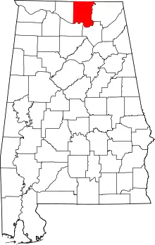 Map of Alabama highlighting Madison County | |
| Towns | ||
| CDPs | ||
| Unincorporated communities | ||
| Footnotes | ‡This populated place also has portions in an adjacent county or counties | |
| ||
