Heiden, Switzerland
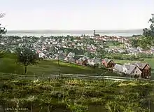
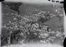
Heiden is a village and a municipality in the canton of Appenzell Ausserrhoden in Switzerland. Its Biedermeier village around the church square is listed as a heritage site of national significance.[3]
Heiden | |
|---|---|
 | |
 Coat of arms | |
Location of Heiden 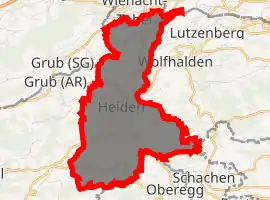
| |
 Heiden Heiden | |
| Coordinates: 47°26′N 9°32′E | |
| Country | Switzerland |
| Canton | Appenzell Ausserrhoden |
| District | n.a. |
| Government | |
| • Executive | Gemeinderat with 7 members |
| • Mayor | Gemeindepräsident(in) Gallus Pfister FDP/PRD |
| • Parliament | none (Kommissionen) |
| Area | |
| • Total | 7.5 km2 (2.9 sq mi) |
| Elevation (Protestant Church) | 793 m (2,602 ft) |
| Population (2018-12-31)[2] | |
| • Total | 4,161 |
| • Density | 550/km2 (1,400/sq mi) |
| Time zone | UTC+01:00 (Central European Time) |
| • Summer (DST) | UTC+02:00 (Central European Summer Time) |
| Postal code(s) | 9410 |
| SFOS number | 3032 |
| Surrounded by | Eggersriet (SG), Grub, Lutzenberg, Oberegg (AI), Rehetobel, Reute, Thal (SG), Wald, Wolfhalden |
| Twin towns | Bezau (Austria) |
| Website | http://www.heiden.ch SFSO statistics |
History
Heiden is first mentioned in 1461 as guot genant Haiden.[4]
Heiden, Lutzenberg and Wolfhalden originally were parts of a single municipality named the Kurzenberg. Around 1650 Heiden and Wolfhalden could not agree about control over the local church. This led to the creation of a church in each village in 1652, making them independent. In 1658 the Kurzenberg was split into the three separate municipalities in defiance of the canton government; their borders were officially established in 1666-7.[5]
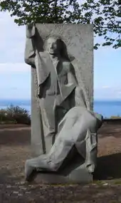
The founder of the Red Cross, Henry Dunant, spent his last years in Heiden. The former president of the ICRC, Jakob Kellenberger, was also born in Heiden.
Geography
Heiden has an area, as of 2006, of 7.5 km2 (2.9 sq mi). Of this area, 52.4% is used for agricultural purposes, while 30.6% is forested. Of the rest of the land, 16.8% is settled (buildings or roads) and the remainder (0.3%) is non-productive (rivers, glaciers or mountains).[6]
The municipality is located in the former District of Vorderland on the Kurzenberg. It consists of the village of Heiden and several hamlets near the village.
Demographics
Heiden has a population (as of 2013) of 4,052, of which about 18.3% are foreign nationals.[7] Over the last 10 years the population has decreased at a rate of -4.2%. Most of the population (as of 2000) speaks German (88.7%), with Croatian being second most common ( 5.9%) and Italian being third ( 1.1%).[6]
As of 2000, the gender distribution of the population was 48.5% male and 51.5% female.[8] The age distribution, as of 2000, in Heiden is; 311 people or 7.7% of the population are between 0–6 years old. 512 people or 12.6% are 6-15, and 219 people or 5.4% are 16-19. Of the adult population, 168 people or 4.1% of the population are between 20–24 years old. 1,179 people or 29.0% are 25-44, and 966 people or 23.8% are 45-64. The senior population distribution is 491 people or 12.1% of the population are between 65–79 years old, and 217 people or 5.3% are over 80.[8]
In the 2007 federal election the FDP received 65% of the vote.[6]
In Heiden about 68.3% of the population (between age 25-64) have completed either non-mandatory upper secondary education or additional higher education (either university or a Fachhochschule).[6]
Heiden has an unemployment rate of 1.61%. As of 2005, there were 93 people employed in the primary economic sector and about 37 businesses involved in this sector. 708 people are employed in the secondary sector and there are 41 businesses in this sector. 1,428 people are employed in the tertiary sector, with 189 businesses in this sector.[6]
The historical population is given in the following table:[4][8]
| Year | Pop. | ±% |
|---|---|---|
| 1667 | 1,248 | — |
| 1813 | 1,776 | +42.3% |
| 1818 | 1,630 | −8.2% |
| 1850 | 2,466 | +51.3% |
| 1900 | 3,745 | +51.9% |
| 1941 | 2,904 | −22.5% |
| 1950 | 3,094 | +6.5% |
| 1980 | 3,620 | +17.0% |
| 1990 | 3,885 | +7.3% |
| 2000 | 4,074 | +4.9% |
| 2005 | 3,993 | −2.0% |
| 2007 | 4,050 | +1.4% |
Transportation
A frequent rack railway, the Rorschach-Heiden-Bahn, leads from Rorschach next to Lake Constance, 400 meters (1,300 ft) below, to Heiden. Heiden is also connected by several frequent Swiss PostAuto lines.
References
- "Arealstatistik Standard - Gemeinden nach 4 Hauptbereichen". Federal Statistical Office. Retrieved 13 January 2019.
- "Ständige Wohnbevölkerung nach Staatsangehörigkeitskategorie Geschlecht und Gemeinde; Provisorische Jahresergebnisse; 2018". Federal Statistical Office. 9 April 2019. Retrieved 11 April 2019.
- Swiss inventory of cultural property of national and regional significance (1995), p. 54.
- Heiden in German, French and Italian in the online Historical Dictionary of Switzerland.
- Kurzenberg in German, French and Italian in the online Historical Dictionary of Switzerland.
- Swiss Federal Statistical Office Archived 2016-01-05 at the Wayback Machine accessed 15-Sep-2009
- Brief Statistics for the half-canton Archived 12 June 2011 at the Wayback Machine (in German) accessed 15 September 2009
- Appenzell Outer Rhodes website Archived 2009-09-13 at the Wayback Machine (in German) accessed 15 September 2009
| Wikimedia Commons has media related to Heiden AR. |
