Henichesk Strait
The Henichesk Strait (alternatively Genichesk Strait; Russian: Генический пролив, Ukrainian: Генічеська протока) is a narrow strait which connects the Syvash (the shallow lagoon system separating the Crimea from the Ukraine east of the Isthmus of Perekop) with the Sea of Azov. It separates the Arabat Spit from the Ukrainian mainland.[1]
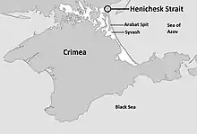
The strait is about 4 kilometres (2.5 mi) long and the width varies from 80 to 150 metres (260 to 490 ft), with a depth of 4.6 metres (15 ft).[1][2] On account of its narrowness, it is also sometimes called Thin Strait (Russian: Тонкий пролив, Ukrainian: тонкий протоку).[2] The direction of flow depends on the wind. On the north side of the strait is the town and port of Henichesk in the Ukraine.[1]
Although the strait separates the Crimea from the Ukraine geographically, it does not do so politically: both sides of the strait are in the Ukrainian Kherson Oblast, and the political and military boundary between Kherson Oblast and the disputed polity described either as the Ukrainian Autonomous Republic of Crimea or the Russian Republic of Crimea lies further south on the Arabat Spit.
.jpg.webp)
References
- Genichesk Strait article from the Great Soviet Encyclopedia, cited at пролив/БСЭ/Генический пролив/ "Генический пролив" Check
|url=value (help) [Genichesk Strait]. Yandex. Retrieved October 4, 2014. (in Russian) - Semenov, Pyotr (1862). Geografichesko-statisticheskìĭ slovar' Rossìĭskoĭ imperìi [Geographical-Statistical Dictionary of the Russian Empire] (in Russian). Oxford University. p. 624.
External links
- Detailed topographical and hydrological map (in Russian)