Hernádnémeti
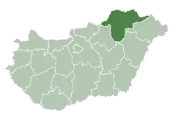
Hernádnémeti is a village in Borsod-Abaúj-Zemplén County in northeastern Hungary.[2] It is situated on the left bank of the Hernád River, 14 kilometres (8.7 mi) from Miskolc. The village is 120 metres (390 ft) above sea level. It can be reached by car via highway 37 or by train from the Hernádnémeti–Bőcs train station, which is located in the neighboring village of Bőcs.
Hernádnémeti | |
|---|---|
Large village | |
 | |
 Flag  Coat of arms | |
 Hernádnémeti Location of Hernádnémeti | |
| Coordinates: 48.07948°N 20.97236°E | |
| Country | Hungary |
| Region | Northern Hungary |
| County | Borsod-Abaúj-Zemplén |
| District | Miskolc |
| Area | |
| • Total | 28.76 km2 (11.10 sq mi) |
| Population (1 January 2015)[1] | |
| • Total | 3,421 |
| • Density | 120/km2 (310/sq mi) |
| Time zone | UTC+1 (CET) |
| • Summer (DST) | UTC+2 (CEST) |
| Postal code | 3564 |
| Area code | (+36) 46 |
| Website | www |
History
The village was originally settled in the times of Prince Árpád. During the Mongol invasion it was completely depopulated; it was resettled in 1254 by Germans who were invited to the country by the king. From these German settlers the village gets its name (német being the word in Hungarian for German).
The village was again destroyed during the Turkish invasions; in 1567 the area is referred to as being unpopulated. Gradually it was repopulated and in 1596 it was included into the Rákóczi estates. At this time the village became Protestant due to an influx of hajduk settlers.
References
- "Gazetteer of Hungary, 1st January 2015" (in Hungarian). Hungarian Central Statistical Office. 3 September 2015. Retrieved 4 September 2015.
- Központi Statisztikai Hivatal (KSH) (in Hungarian)