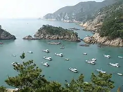
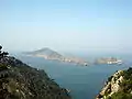
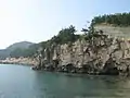
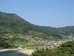
Heuksando
Heuksando is an island in the Yellow Sea located off 97.2 km from the southwest coast of Mokpo, Jeollanam-do, South Korea. It covers an area of 19.7㎢ and consists of several peaks: Munamsan (문암산/門岩山 400m), Gitdaebong (깃대봉/깃대峰 378m), Seonyubong (선유봉/仙遊峰 300m), Sangnasan (상라산/象羅山 227m). It is within the administrative boundaries of Sinan County, Jeollanam-do, South Korea since 1969. The island's 19.7 km² are home to about 3,133 people.[1]
Heuksando | |
|---|---|
| Korean transcription(s) | |
| • Hangul | 흑산도 |
| • Hanja | 黑山島 |
| • Revised Romanization | Heuksando |
| • McCune–Reischauer | Hŭksando |
 | |
| Country | South Korea |
| Area | |
| • Total | 19.7 km2 (7.6 sq mi) |
| Population (2001) | |
| • Total | 3,133 |
| • Density | 160/km2 (410/sq mi) |
Climate
| Climate data for Heuksando (1981–2010, extremes 1997–present) | |||||||||||||
|---|---|---|---|---|---|---|---|---|---|---|---|---|---|
| Month | Jan | Feb | Mar | Apr | May | Jun | Jul | Aug | Sep | Oct | Nov | Dec | Year |
| Record high °C (°F) | 16.5 (61.7) |
16.6 (61.9) |
23.3 (73.9) |
25.7 (78.3) |
28.6 (83.5) |
30.1 (86.2) |
32.7 (90.9) |
33.9 (93.0) |
31.1 (88.0) |
26.3 (79.3) |
22.3 (72.1) |
17.4 (63.3) |
33.9 (93.0) |
| Average high °C (°F) | 5.3 (41.5) |
6.3 (43.3) |
9.4 (48.9) |
14.2 (57.6) |
18.6 (65.5) |
22.4 (72.3) |
25.5 (77.9) |
27.6 (81.7) |
24.0 (75.2) |
19.3 (66.7) |
13.7 (56.7) |
8.1 (46.6) |
16.2 (61.2) |
| Daily mean °C (°F) | 3.3 (37.9) |
3.8 (38.8) |
6.2 (43.2) |
10.5 (50.9) |
14.9 (58.8) |
19.0 (66.2) |
22.6 (72.7) |
24.5 (76.1) |
21.4 (70.5) |
16.9 (62.4) |
11.3 (52.3) |
5.9 (42.6) |
13.3 (55.9) |
| Average low °C (°F) | 1.4 (34.5) |
1.8 (35.2) |
3.8 (38.8) |
7.8 (46.0) |
12.0 (53.6) |
16.4 (61.5) |
20.4 (68.7) |
22.3 (72.1) |
19.6 (67.3) |
15.2 (59.4) |
9.4 (48.9) |
3.9 (39.0) |
11.2 (52.2) |
| Record low °C (°F) | −8.7 (16.3) |
−5.9 (21.4) |
−3.9 (25.0) |
0.6 (33.1) |
6.3 (43.3) |
11.1 (52.0) |
15.6 (60.1) |
17.5 (63.5) |
14.8 (58.6) |
4.6 (40.3) |
−0.2 (31.6) |
−4.8 (23.4) |
−8.7 (16.3) |
| Average precipitation mm (inches) | 22.1 (0.87) |
33.2 (1.31) |
48.8 (1.92) |
81.2 (3.20) |
102.4 (4.03) |
174.7 (6.88) |
226.0 (8.90) |
197.1 (7.76) |
117.5 (4.63) |
45.4 (1.79) |
35.0 (1.38) |
23.9 (0.94) |
1,107.3 (43.59) |
| Average precipitation days (≥ 0.1 mm) | 9.1 | 7.1 | 8.6 | 9.1 | 9.0 | 10.4 | 13.3 | 12.0 | 9.9 | 6.4 | 7.5 | 9.6 | 112 |
| Average snowy days | 9.2 | 4.8 | 2.2 | 0.1 | 0.0 | 0.0 | 0.0 | 0.0 | 0.0 | 0.0 | 0.5 | 6.6 | 23.4 |
| Average relative humidity (%) | 68.7 | 70.6 | 72.7 | 76.5 | 80.9 | 86.7 | 92.0 | 88.2 | 82.6 | 73.1 | 68.8 | 67.5 | 77.4 |
| Mean monthly sunshine hours | 96.3 | 138.5 | 186.5 | 201.4 | 191.2 | 154.2 | 114.7 | 188.1 | 180.3 | 203.8 | 148.5 | 108.0 | 1,911.7 |
| Percent possible sunshine | 30.7 | 44.9 | 50.3 | 51.4 | 44.1 | 35.6 | 26.0 | 45.2 | 48.4 | 58.1 | 47.7 | 35.2 | 42.9 |
| Source: Korea Meteorological Administration[2][3][4] (percent sunshine and snowy days)[5] | |||||||||||||
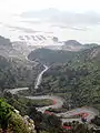
Gallery
See also
- Jang Bo-go
- Islands of South Korea
- List of Korea-related topics
References
- 흑산도 黑山島 (in Korean). Doosan Encyber. Retrieved 2008-05-05.
- 평년값자료 (1981–2010) 흑산도 (169) (in Korean). Korea Meteorological Administration. Retrieved 23 May 2011.
- 기후자료 극값(최대값) 전체년도 일최고기온 (℃) 최고순위, 흑산도 (169) (in Korean). Korea Meteorological Administration. Retrieved 12 January 2017.
- 기후자료 극값(최대값) 전체년도 일최저기온 (℃) 최고순위, 흑산도 (169) (in Korean). Korea Meteorological Administration. Retrieved 12 January 2017.
- "Climatological Normals of Korea" (PDF). Korea Meteorological Administration. 2011. p. 499 and 649. Archived from the original (PDF) on 7 December 2016. Retrieved 12 January 2017.
This article is issued from Wikipedia. The text is licensed under Creative Commons - Attribution - Sharealike. Additional terms may apply for the media files.