Yellow Sea
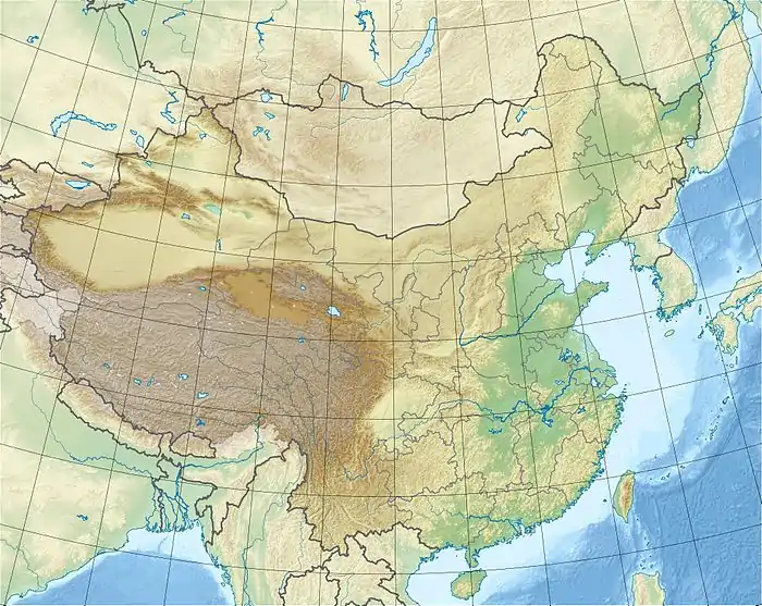
The Yellow Sea is a marginal sea of the Western Pacific Ocean located between mainland China and the Korean Peninsula, and can be considered the northwestern part of the East China Sea. It is one of four seas named after common colour terms (the others being the Black Sea, the Red Sea and the White Sea), and its name is descriptive of the phenomenon whereby fine sand grains from the Gobi Desert sand storms, that descend annually from the northwest, turn the surface of its waters a golden yellow.
| Yellow Sea | |
|---|---|
 Yellow Sea | |
| Coordinates | 38°0′N 123°0′E |
| River sources | Yellow River, Hai River, Yalu River, Taedong River, Han River |
| Basin countries | China, North Korea, and South Korea |
| Surface area | 380,000 km2 (150,000 sq mi) |
| Average depth | Avg. 44 m (144 ft) |
| Max. depth | Max. 152 m (499 ft) |
| Yellow Sea | |||||||||||||||
|---|---|---|---|---|---|---|---|---|---|---|---|---|---|---|---|
 | |||||||||||||||
| Chinese name | |||||||||||||||
| Simplified Chinese | 黄海 | ||||||||||||||
| Traditional Chinese | 黃海 | ||||||||||||||
| Literal meaning | Yellow Sea | ||||||||||||||
| |||||||||||||||
| Korean name | |||||||||||||||
| Hangul | 황해 or 서해 | ||||||||||||||
| Hanja | 黃海 or 西海 | ||||||||||||||
| Literal meaning | Yellow Sea or West Sea | ||||||||||||||
| |||||||||||||||
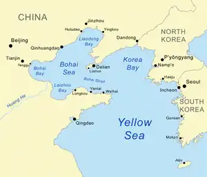
The innermost bay of northwestern Yellow Sea is called the Bohai Sea (previously Pechihli Bay or Chihli Bay), into which flow some of the most important rivers of northern China, such as the Yellow River (through Shandong province and its capital Jinan), the Hai River (through Beijing and Tianjin) and the Liao River (through Liaoning province). Sand and silt carried down by these rivers contribute further to the sea's colour. The northern extension of the Yellow Sea is called the Korea Bay, into which flow the Yalu River, the Chongchon River and the Taedong River.
Since 1 November 2018, the Yellow Sea has also served as the location of "peace zones" between North and South Korea.[1]
Geography
Extent
The International Hydrographic Organization defines the limits of the Yellow Sea (which it also names as "Hwang Hai") as follows:[2]
The Yellow Sea is separated from the Sea of Japan by the boundary from the southern end of Haenam Peninsula in Jeollanamdo to Jeju Island and divided into the East China Sea by the boundary from the west end of Jeju Island to the Yangtze River estuary.
Physiography
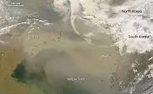
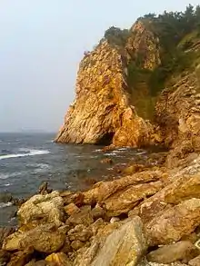
The Yellow Sea, excluding the Bohai, extends by about 960 km (600 mi) from north to south and about 700 km (430 mi) from east to west; it has an area of approximately 380,000 km2 (150,000 sq mi) and a volume of about 17,000 km3 (4,100 cu mi).[4] Its depth is only 44 m (144 ft) on average, with a maximum of 152 m (499 ft). The sea is a flooded section of continental shelf that formed after the last ice age (some 10,000 years ago) as sea levels rose 120 m (390 ft) to their current levels. The depth gradually increases from north to south.[4] The sea bottom and shores are dominated by sand and silt brought by the rivers through the Bohai Sea (Liao River, Yellow River, Hai He) and the Korea Bay (Yalu River). These deposits, together with sand storms are responsible for the yellowish colour of the water referenced in the sea's name.[5]
Major islands of the sea include Anmado, Baengnyeongdo, Daebudo, Deokjeokdo, Gageodo, Ganghwado, Hauido, Heuksando, Hongdo, Jejudo, Jindo, Muuido, Sido, Silmido, Sindo, Wando, Yeongjongdo and Yeonpyeongdo (all in South Korea).
Climate and hydrology
The area has cold, dry winters with strong northerly monsoons blowing from late November to March. Average January temperatures are −10 °C (14 °F) in the north and 3 °C (37 °F) in the south. Summers are wet and warm with frequent typhoons between June and October.[4] Air temperatures range between 10 and 28 °C (50 and 82 °F). The average annual precipitation increases from about 500 mm (20 in) in the north to 1,000 mm (39 in) in the south. Fog is frequent along the coasts, especially in the upwelling cold-water areas.[5]
The sea has a warm cyclone current, forming part of the Kuroshio Current, which diverges near the western part of Japan and flows northward into the Yellow Sea at the speed of below 0.8 km/h (0.50 mph). Southward currents prevail near the sea coast, especially in the winter monsoon period.[5]
The water temperature is close to freezing in the northern part in winter, so drift ice patches and continuous ice fields form and hinder navigation between November and March. The water temperature and salinity are homogeneous across the depth. The southern waters are warmer at 6–8 °C (43–46 °F). In spring and summer, the upper layer is warmed up by the sun and diluted by the fresh water from rivers, while the deeper water remains cold and saline. This deep water stagnates and slowly moves south. Commercial bottom-dwelling fishes are found around this mass of water, especially at its southern part. Summer temperatures range between 22 and 28 °C (72 and 82 °F). The average salinity is relatively low, at 30‰ in the north to 33–34‰ in the south, dropping to 26‰ or lower near the river deltas. In the southwest monsoon season (June to August) the increased rainfall and runoff further reduce the salinity of the upper sea layer.[5] Water transparency increases from about 10 meters (33 ft) in the north up to 45 meters (148 ft) in the south.[4]
Tides are semidiurnal, i.e. rise twice a day. Their amplitude varies between about 0.9 and 3 meters (3.0 and 9.8 ft) at the coast of China. Tides are higher at the Korean Peninsula, typically ranging between 4 and 8 meters (13 and 26 ft) and reaching the maximum in spring. The tidal system rotates in a counterclockwise direction. The speed of the tidal current is generally less than 1.6 km/h (0.99 mph) in the middle of the sea, but may increase to more than 5.6 km/h (3.5 mph) near the coasts.[5] The fastest tides reaching 20 km/h (12 mph) occur in the Myeongnyang Strait between the Jindo Island and the Korean Peninsula.[7]
The tide-related sea level variations result in a land pass 2.9 km (1.8 mi) long and 10–40 meters (33–131 ft) wide opening for approximately an hour between Jindo and Modo islands. The event occurs about twice a year, at the beginning of May and in the middle of June. It had long been celebrated in a local festival called "Jindo Sea Parting Festival", but was largely unknown to the world until 1975, when the French ambassador Pierre Randi described the phenomenon in a French newspaper.[8][9][10]
Flora and fauna
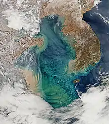
The sea is rich in seaweed (predominantly kelp, Laminaria japonica), cephalopods, crustaceans, shellfish, clams, and especially in blue-green algae which bloom in summer and contribute to the water color (see image above). For example, the seaweed production in the area was as high as 1.5 million tonnes in 1979 for China alone. The abundance of all these plant and animal species increases toward the south and indicates a high sea productivity, accounting for the diversity of fish species and high fish yield from the sea.[12] Several species of goby new to science have been discovered recently in the Yellow Sea.[13]
The southern part of the Yellow Sea, including the entire west coast of Korea, contains a 10 km-wide (6.2 mi) belt of intertidal mudflats, which has the total area of 2,850 km2 (1,100 sq mi) and is maintained by 4–10 m (13–33 ft). Those flats consist of highly productive sediments with a rich benthic fauna and are of great importance for migratory waders and shorebirds.[14] Surveys show that the area is the single most important site for migratory birds on northward migration in the entire East Asian – Australasian Flyway, with more than 35 species occurring in internationally significant numbers. Two million birds, at minimum, pass through at the time, and about half that number use it on southward migration.[15][16] About 300,000 migrating birds were transiting annually only through the Saemangeum tidal flat area. This estuary was however dammed by South Korea in 1991–2006 that resulted in drying off the land.[17] Land reclamation also took 65% of the intertidal area in China between the 1950s and 2002,[18] and there are plans to reclaim a further 45%.[19]
Oceanic megafaunas'bio-diversities, such as of marine mammals, sea turtles, and larger fish drastically decreased in modern time not only by pollution but also mainly by direct hunting, most extensively Japanese industrial whaling,[20] illegal mass operations by Soviet with supports from Japan.[21] and fewer species survived to today although being still in serious perils. Those include spotted seals, and cetaceans such as minke whales, killer whales,[22] false killer whales, and finless porpoises, but nonetheless all the remnants of species listed could be in very small numbers. Historically, large whales were very abundant either for summering and wintering in the Yellow and Bohai Seas. For example, a unique population of resident fin whales and gray whales[23] were historically presented,[24] or possibly hosted some North Pacific right whales[25][26] and Humpback whales (3 whales including a cow calf pair was observed at Changhai County in 2015[27][28]) year-round other than migrating individuals, and many other migratory species such as Baird's beaked whales.[29] Even blue whales, Japanese sea lions, dugongs (in southern regions only),[30] and leatherback turtles used to breed or migrate into Yellow and Bohai seas.[31]
Spotted seals are only species thriving in today's Yellow Sea and being the only resident species as well. A sanctuary for these seals is situated at Baengnyeongdo which is also known for local finless porpoises.[32] Great white sharks have been spotted to prey on seals in these areas as well.[33]
Economy
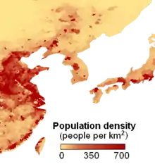
The coasts of the Yellow Sea are very densely populated, at approximately 250 inhabitants per square kilometer (650/sq mi).[34] The sea waters had been used for fishing by the Chinese, Korean and Japanese ships for centuries. Especially rich in fish are the bottom layers. About 200 fish species are exploited commercially, especially sea bream, croakers, lizard fishes, prawns, cutlassfish, horse mackerel, squid, eel, filefish, Pacific herring, chub mackerel, flounder[35] and jellyfish.[36] The intensity of fishing has been gradually increasing for China and Korea and decreasing for Japan. For example, the production volumes for China rose from 619,000 tonnes in 1985 to 1,984,400 tonnes in 1996.[37] All species are overfished, however, and while the total catchments are rising, the fish population is continuously declining for most species.[5][38]
Navigation is another traditional activity in the Yellow Sea. The main Chinese ports are Dalian, Tianjin, Qingdao and Qinhuangdao. The major South Korean ports on the Yellow Sea are Incheon, Gunsan and Mokpo, and that for North Korea is Nampho, the outport of Pyongyang. The Bohai Train Ferry provides a shortcut between the Liaodong Peninsula and Shandong.[5] A major naval accident occurred on 24 November 1999 at Yantai, Shandong, China when the 9,000-ton Chinese ferry Dashun caught fire and capsized in rough seas. About 300 people were killed making it the worst maritime incident in China.[39]
Oil exploration has been successful in the Chinese and North Korean portions of the sea, with the proven and estimated reserves of about 9 and 20 billion tonnes, respectively.[40] However, the study and exploration of the sea is somewhat hindered by insufficient sharing of information between the involved countries. China initiated collaborations with foreign oil companies in 1979, but this initiative declined later.[5]
A major oil spill occurred on 16 July 2010 when a pipeline exploded at the north-east port of Dalian, causing a wide-scale fire and spreading about 1,500 tonnes of oil over the sea area of 430 km2 (170 sq mi). The port had been closed and fishing suspended until the end of August. Eight hundred fishing boats and 40 specialized vessels were mobilized to relieve the environmental damage.[41]
State of the environment
The Yellow Sea is considered among the most degraded marine areas on earth.[42] Loss of natural coastal habitats due to land reclamation has resulted in the destruction of more than 60% of tidal wetlands around the Yellow Sea coastline in approximately 50 years.[18] Rapid coastal development for agriculture, aquaculture and industrial development are considered the primary drivers of coastal destruction in the region.[18] This degree of loss of area, widespread pollution, algal blooms and declines of invertebrate and vertebrate fauna have resulted in the classification of this ecosystem as endangered.[43]
In addition to land reclamation, the Yellow Sea ecosystem is facing several other serious environmental problems. Pollution is widespread and deterioration of pelagic and benthic habitat quality has occurred, and harmful algal blooms frequently occur.[44] Invasion of introduced species are having a detrimental effect on the Yellow Sea environment. There are 25 intentionally introduced species and 9 unintentionally introduced species in the Yellow Sea Large Marine Ecosystem.[42] Declines of biodiversity, fisheries and ecosystem services in the Yellow Sea are widespread.[42]
The tidal flats of the Yellow Sea are considered endangered.[43]
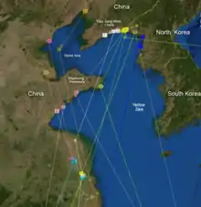
Location of Korean Peace Zones
On 1 November 2018, officials from South Korea's Ministry of National Defense confirmed that "peace zones" had been established by the North and South Korean militaries in the Yellow Sea area that touches the North and South Korean demarcation line.[1] A buffer zone was also created in the Yellow Sea's Northern Limit Line (NLL).[45]
See also
References
- "Koreas halt all 'hostile' military acts near border". November 2018.
- "Limits of Oceans and Seas" (PDF) (3rd ed.). International Hydrographic Organization. 1953. Retrieved 28 December 2020.
- Sand storm over Yellow Sea, nasa.gov
- Yellow Sea, Great Soviet Encyclopedia (in Russian)
- Yellow Sea, Encyclopædia Britannica on-line
- Sediments and Phytoplankton bloom near the Mouth of the Yangtze, East China Sea Archived 30 June 2010 at the Wayback Machine, NASA, 2002
- M. J. King, et al. Twinning of Jindo Grand Bridge, Republic of Korea in Current and future trends in bridge design, construction and maintenance 2: safety, economy, sustainability and aesthetics; proceedings of the international conference organized by the Institution of Civil Engineers and held in Hong Kong on 25–26 April 2001 ISBN 0-7277-3091-6 pp. 175, 177
- The Moses Miracle Of Jindo Island, 17 July 2010
- Майские фестивали в Чолладо – от "чуда Моисея" до боя быков Archived 31 July 2009 at the Wayback Machine (in Russian)
- Jindo Mysterious Sea Road Archived 3 March 2012 at the Wayback Machine, Jindo County
- Bar-tailed Godwit Updates Archived 20 February 2013 at the Wayback Machine, USGS
- Chikuni, pp. 8, 16, 19
- esa. "Earth from Space: The Yellow Sea of China".
- Maurice L. Schwartz (2005) Encyclopedia of coastal science, ISBN 1-4020-1903-3 p. 60
- Barter, M.A. (2002). Shorebirds of the Yellow Sea – importance, threats and conservation status. Wetlands International Global Series Vol. 9. International Wader Studies Vol. 12. Canberra ISBN 90-5882-009-2
- Barter, M.A. (2005). Yellow Sea – driven priorities for Australian shorebird researchers. pp. 158–160 in: "Status and Conservation of Shorebirds in the East Asian – Australasian Flyway". Proceedings of the Australasian Shorebird Conference, 13–15 December 2003, Canberra, Australia. International Wader Studies 17. Sydney.
- Saemangeum and the Saemangeum Shorebird Monitoring Program (SSMP) 2006–2008, Birds Korea
- Murray, Nicholas J.; Clemens, Robert S.; Phinn, Stuart R.; Possingham, Hugh P.; Fuller, Richard A. (2014). "Tracking the rapid loss of tidal wetlands in the Yellow Sea" (PDF). Frontiers in Ecology and the Environment. 12 (5): 267–72. doi:10.1890/130260.
- David Lindenmayer, Mark Burgman, Mark A. Burgman (2005) Practical conservation biology, ISBN 0-643-09089-4 p. 172
- Weller, D.; et al. (2002). "The western gray whale: a review of past exploitation, current status and potential threats". J. Cetacean Res. Manage. 4 (1): 7–12. Retrieved 10 March 2016.
- Berzin A.; Ivashchenko V.Y.; Clapham J.P.; Brownell L. R.Jr. (2008). "The Truth About Soviet Whaling: A Memoir". DigitalCommons@University of Nebraska - Lincoln. Retrieved 10 March 2016.
- "Distribution of Whales and Dolphins in Korean Waters Based on a Sighting Survey from 2000 to 2010" (PDF). ocean.kisti.re.kr. Retrieved 19 September 2020.
- "A Gray Area: On the Matter of Gray Whales in the Western North Pacific (PDF Download Available)". ResearchGate.
- MIZROCH A.S.. RICE W.D.. ZWIEFELHOFER D.. WAITE J.. PERRYMAN L.W.. 2009. Distribution and movements of fin whales in the North Pacific Ocean. on The Wiley Online Library. Retrieved on 3 January. 2015
- "我国沿海鲸类(一)——须鲸篇(下)_科学公园_传送门". chuansong.me.
- Monsarrat Sophie (2016). "A spatially explicit estimate of the prewhaling abundance of the endangered North Atlantic right whale". Conservation Biology. 30 (4): 783–791. doi:10.1111/cobi.12664. PMID 26632250.
- "长海又现鲸鱼 这回是好几条". Archived from the original on 9 June 2016.
- 大连长海又见鲸鱼一家亲!三条!四条 Archived 2 June 2016 at the Wayback Machine
- Huogen W.; Yu W. (1998). "A Baird's Beaked Whale From the East China Sea". Fisheries Science, 1998-05: CNKI – The China National Knowledge Infrastructure. Retrieved 7 September 2015.
- "Archived copy". Archived from the original on 10 March 2016. Retrieved 10 March 2016.CS1 maint: archived copy as title (link)
- Mr.Z. Charlie. 2008. 我国的渤海里有没有鲸鱼 on Sogou - Wenwen. Retrieved on 3 January. 2015
- "백령도 어부들의 친구 쇠돌고래".
- "백상아리, 백령도서 물범 공격장면 국내 첫 포착 - 민중의소리". www.vop.co.kr.
- Population Density Archived 22 July 2010 at the Wayback Machine, NASA, 1994
- Chikuni, p. 25
- AFP, Agence France-Presse (22 November 2016). "China's jellyfish-hauling mules a dying breed". www.atimes.com. Retrieved 2 December 2016.
- Fishing Industry Archived 27 May 2010 at the Wayback Machine, noaa.gov
- Chikuni, pp. 37, 47, 55
- Ferry sinks in Yellow Sea, killing hundreds, 24 November 1999
- China found new large oil field in the Yellow Sea, News.ru, 3 May 2007 (in Russian)
- China's worst-ever oil spill threatens wildlife as volunteers assist in clean-up, Guardian, 21 July 2010
- UNDP/GEF. (2007) The Yellow Sea: Analysis of Environmental Status and Trends. p. 408, Ansan, Republic of Korea.
- Murray, Nicholas J.; Ma, Zhijun; Fuller, Richard A. (2015). "Tidal flats of the Yellow Sea: A review of ecosystem status and anthropogenic threats" (PDF). Austral Ecology. 40 (4): 472–481. doi:10.1111/aec.12211. ISSN 1442-9985.
- "China's largest algal bloom turns the Yellow Sea green". The Guardian.
- "[File] NLL buffer zone, there is a Marine Corps. | tellerreport.com". www.tellerreport.com.
Bibliography
- Chikuni, S. (1985) The fish resources of the northwest Pacific, Food and Agriculture Organization, ISBN 92-5-102298-4
| Authority control |
|---|