Hexie Mountains
The Hexie Mountains are a desert mountain range located in Joshua Tree National Park, in southern California.
| Hexie Mountains | |
|---|---|
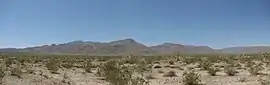 Hexie Mountains seen from the north | |
| Highest point | |
| Elevation | 1,167 m (3,829 ft) |
| Coordinates | 33°53′12.039″N 115°57′20.992″W |
| Geography | |
 location of Hexie Mountains in California [1]  Hexie Mountains (the United States) | |
| Country | United States |
| State | California |
| District | Riverside County |
| Range coordinates | 33°53′12″N 115°57′21″W |
| Borders on | Eagle Mountains |
| Topo map | USGS Fried Liver Wash |
Geography
The range is located in the higher northern Mojave Desert area of the park. They are north of the Cottonwood Mountains, and south of the Pinto Mountains. The Eagle Mountains lie to the east of the Hexie Mountains.
Natural history
Numerous washes drain the Hexie Mountains, including Porcupine Wash and Fried Liver Wash. These host a mixture of low and high desert animals and plants. A herd of desert bighorn sheep also live there.
History
There were attempts to mine and mill gold at many sites, including Ruby Lee Mill, and none were successful. Native petroglyphs can also be found in the Hexie Mountains.
References
- "Hexie Mountains". Geographic Names Information System. United States Geological Survey. Retrieved 2009-05-04.
This article is issued from Wikipedia. The text is licensed under Creative Commons - Attribution - Sharealike. Additional terms may apply for the media files.
