Hikutavake
Hikutavake is one of the fourteen villages of Niue.[2] Its population at the 2017 census was 49, up from 40 in 2011.[3]
Hikutavake | |
|---|---|
 Hikutavake council within Niue | |
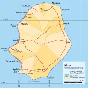 Administrative map of Niue showing all the villages | |
| Coordinates: 18°57′54″S 169°52′53″W | |
| Country | |
| Tribal Area | Motu |
| Area | |
| • Total | 10.17 km2 (3.93 sq mi) |
| Population (2017)[1] | |
| • Total | 49 |
| • Density | 3.93/km2 (10.2/sq mi) |
| Time zone | UTC-11 (UTC-11) |
| Area code(s) | +683 |
Location & geography
About 95% of the land surface is coral rock.[4]
There is a trail on the north side of Niue that leads to a clifftop to an enclosed reef with natural pools, some of them are 10 metres deep and 25 metres across.[5]
References
- "Niue Household and Population Census 2017" (PDF). niue.prism.spc.int. Niue Statistics Office. Retrieved 5 May 2020.
- 1558546 Hikutavake on OpenStreetMap
- "Niue Household and Population Census 2017" (PDF). niue.prism.spc.int. Niue Statistics Office. Retrieved 5 May 2020.
- Wright, A. C. S. (1965). Soils and Agriculture of Niue Island. p. 38.
- Atkinson, Brett (2013-03-24). "Niue: Natural wonders". NZ Herald. ISSN 1170-0777. Retrieved 2020-04-25.
This article is issued from Wikipedia. The text is licensed under Creative Commons - Attribution - Sharealike. Additional terms may apply for the media files.
