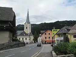
Himmelberg
Himmelberg (Slovene: Sokolovo) is a town in the district of Feldkirchen in the Austrian state of Carinthia in Austria.
Himmelberg | |
|---|---|
 | |
 Coat of arms | |
 Himmelberg Location within Austria | |
| Coordinates: 46°45′N 14°2′E | |
| Country | Austria |
| State | Carinthia |
| District | Feldkirchen |
| Government | |
| • Mayor | Heimo Rinösl |
| Area | |
| • Total | 56.85 km2 (21.95 sq mi) |
| Elevation | 672 m (2,205 ft) |
| Population (2018-01-01)[2] | |
| • Total | 2,287 |
| • Density | 40/km2 (100/sq mi) |
| Time zone | UTC+1 (CET) |
| • Summer (DST) | UTC+2 (CEST) |
| Postal code | 9562 |
| Website | www.himmelberg.at |
Geography
Himmelberg lies in the center of Carinthia northwest of Feldkirchen. It lies in the Tiebel valley. The highest point in the municipality is the Hoferalmkopf (el. ca. 1600 ) in the northwest. The lowest point is the Tiebel (el. 625) in the south of the municipality.
Neighboring municipalities
| Gnesau | Steuerberg | |
| Arriach |  |
|
| Steindorf | Feldkirchen in Kärnten |
References
- "Dauersiedlungsraum der Gemeinden Politischen Bezirke und Bundesländer - Gebietsstand 1.1.2018". Statistics Austria. Retrieved 10 March 2019.
- "Einwohnerzahl 1.1.2018 nach Gemeinden mit Status, Gebietsstand 1.1.2018". Statistics Austria. Retrieved 9 March 2019.
| Wikimedia Commons has media related to Himmelberg. |
| Authority control |
|---|
This article is issued from Wikipedia. The text is licensed under Creative Commons - Attribution - Sharealike. Additional terms may apply for the media files.