Hinterrhein (river)
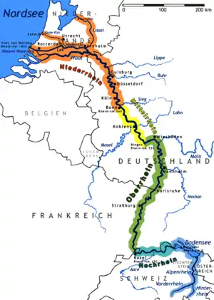
The Hinterrhein (German; Sutsilvan: Ragn Posteriur; Sursilvan: Rein Posteriur; Rumantsch Grischun, Vallader, and Puter: Rain Posteriur; Surmiran: Ragn posteriour; English: Posterior Rhine) is one of the two initial tributaries of the Rhine (less in length but bigger by volume) in the canton of Graubünden in Switzerland, flowing from the village Hinterrhein near the San Bernardino Pass through the Rheinwald valley into a gorge called Roflaschlucht. In this gorge an equally sized tributary, the Avers Rhine, adds waters from the deep Val Ferrera and the very remote alp Avers and its side valley Valle di Lei on Italian territory. After the Rofla Gorge, the valley widens into a section called Schams. The Hinterrhein then reaches Andeer, before passing through another gorge, Viamala just before Thusis. Now another tributary of slightly bigger volume reaches the Hinterrhein as the Landwasser, draining a system of valleys, which is commonly known as Davos joins via the Albula coming from the Albula Pass, which is also the name of a railway line that has become a UNESCO world heritage. Another big tributary of Albula river is Gelgia from the Julier pass area. After flowing to Rothenbrunnen through a valley called Domleschg with an incredible number of castles (showing the importance of transit in the area) again the river is left alone from civilisation in the floodplain Isla Bella near Rhäzüns, before it joins the Anterior Rhine at Reichenau, all of them also in Graubünden.
| Hinterrhein Posterior Rhine | |
|---|---|
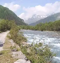 The Hinterrhein southwest of Splügen | |
| Native name | Ragn Posteriur (Sutsilvan) Rein Posteriur (Sursilvan) Rain Posteriur (Rumantsch Grischun) Hinterrhein (German) |
| Location | |
| Country | Switzerland, Italy (Valle di Lei) |
| Physical characteristics | |
| Source | |
| • coordinates | 46°29′55″N 9°3′45″E |
| • elevation | 2,400 m (7,900 ft) |
| Mouth | |
• coordinates | 46°49′24″N 9°24′28″E |
• elevation | 585 m (1,919 ft) |
| Length | 64 km (40 mi) |
| Basin size | 1,693 km2 (654 sq mi) |
| Discharge | |
| • average | 59.6 m3/s (2,100 cu ft/s)[1] |
| Basin features | |
| Progression | Rhine→ North Sea |
| River system | Rhine |
| Tributaries | |
| • right | Ragn da Ferrera, Albula/Alvra |
| Waterbodies | Sufner See |
To learn about the importance of travel along the Hinterrhein, a multiday trekking route is signposted along the river from Thusis to Splügen, where it turns south to Splügen Pass, a historically important transit route to Italy.[2] Nowadays there is no traffic across the Splügen pass in winter, whereas the route across its age-old rival, the San Bernardino Pass, was given a long road tunnel in 1967 that made it possible to keep the road open all year.[3]
References
- Hydrologischer Atlas der Schweiz 2002, Tab. 5.4 Natürliche Abflüsse 1961-1980 (natural discharges) (see map)
- Hiking Switzerland on historical Via Spluga along Hinterrhein Archived 2011-07-06 at the Wayback Machine
- Road closures on passes in Graubünden
| Wikimedia Commons has media related to Hinterrhein. |