Hirschberg, Thuringia
Hirschberg is a town in the Saale-Orla-Kreis district, in Thuringia, Germany. It is situated on the river Saale, 20 km south of Schleiz, 12 km northwest of Hof (Bavaria), and 25 km southwest of Plauen (Saxony).
Hirschberg | |
|---|---|
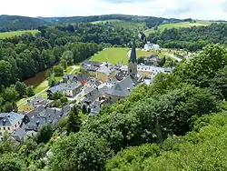 View of the town | |
.png.webp) Coat of arms | |
Location of Hirschberg within Saale-Orla-Kreis district 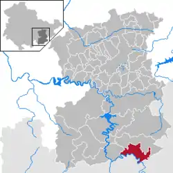 | |
 Hirschberg  Hirschberg | |
| Coordinates: 50°24′21″N 11°49′12″E | |
| Country | Germany |
| State | Thuringia |
| District | Saale-Orla-Kreis |
| Government | |
| • Mayor | Rüdiger Wohl |
| Area | |
| • Total | 24.12 km2 (9.31 sq mi) |
| Elevation | 454 m (1,490 ft) |
| Population (2019-12-31)[1] | |
| • Total | 2,132 |
| • Density | 88/km2 (230/sq mi) |
| Time zone | UTC+01:00 (CET) |
| • Summer (DST) | UTC+02:00 (CEST) |
| Postal codes | 07927 |
| Dialling codes | 036644 |
| Vehicle registration | SOK |
| Website | www.stadt-hirschberg-saale.de |
History
| 1154: | First mentioned in documents.[2] |
| 1871-1918: | Within the German Empire, Hirschberg was part of the Principality of Reuss-Gera. |
| 1966-1990: | Hirschberg served as East German inner German border crossing for cars travelling between the East German Democratic Republic, or West Berlin and the West German Federal Republic of Germany. The traffic was subject to the Interzonal traffic regulations, that between West Germany and West Berlin followed the special regulations of the Transit Agreement (1972). |
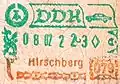 Hirschberg crossing passport stamp.
Demographics, politics and government
Hirschberg is located next to the motorway A 9 (Berlin – Munich). The city includes the subdivisions: Juchhöh, Göritz, Sparnberg, Ullersreuth and Venzka.
Annexation of Subdivisions
The dates into the brackets are the first documentary citations.[3]
- 1. January 1974: Venzka (24. July 1348) with Juchhöh (1713-1715)
- 8. March 1994: Göritz (20. February 1282), Sparnberg (1202) and Ullersreuth (1246)
Population
Trend of population figures (reference[4] is starting at 1994):
|
1830 — 1995
|
1996 — 2000
|
2001 — 2004
|
2006 — 2009
|
Culture
-2008-03a.jpg.webp) Museum of Hirschberg
Museum of Hirschberg-2008-03b.jpg.webp) Village Hall
Village Hall
See also
| Wikimedia Commons has media related to Hirschberg_(Saale). |
References
- "Bevölkerung der Gemeinden, erfüllenden Gemeinden und Verwaltungsgemeinschaften in Thüringen Gebietsstand: 31.12.2019". Thüringer Landesamt für Statistik (in German). August 2020.
- W.Kahl Ersterwähnung Thüringer Städte und Dörfer bis 1300 Verlag Rockstuhl Bad Langensalza 2001 S. 31 ISBN 3-934748-58-9
- Wolfgang Kahl: Ersterwähnung Thüringer Städte und Dörfer,Verlag Rockstuhl,Bad-Langensalza,2010, ISBN 978-3-86777-202-0,S.298,134,93,169,292
- Thuringia State Office for Statistics (German)
This article is issued from Wikipedia. The text is licensed under Creative Commons - Attribution - Sharealike. Additional terms may apply for the media files.
