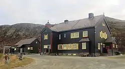
Hjerkinn
Hjerkinn is a village in the municipality of Dovre, in Innlandet county in Norway. It is one of the driest places in the country, with only 222 millimetres (8.7 in) annual precipitation in the 10-year period 1905-14.[2]
Hjerkinn | |
|---|---|
Village | |
 Hjerkinn station | |
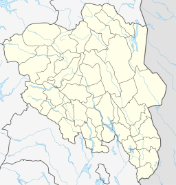 Hjerkinn Location in Innlandet  Hjerkinn Hjerkinn (Norway) | |
| Coordinates: 62°13′23″N 009°33′01″E | |
| Country | |
| Region | Northern Norway |
| County | Oppland |
| District | Øst-Oppland |
| Municipality | Dovre |
| Elevation | 1,020 m (3,350 ft) |
| Time zone | UTC+01:00 (CET) |
| • Summer (DST) | UTC+02:00 (CEST) |
The railway station Hjerkinn Station is located on the Dovre Line, at 1,017 metres (3,337 ft) above mean sea level.[3] The highway E6 also passes through the village. It is also served by a small airport. Until 1993 there was mining by Folldal Gruver. The Norwegian military has a camp at Hjerkinn.
The name
The Old Norse form of the name was Hjarðkinn. The first element is probably the stem form of hjǫrðr m 'herd, flock of cattle or sheep', the last element is kinn n 'steep mountainside'. The village of Hjerkinn is lying beneath steep mountainsides, and since this place was an important crossroads with roads to Oppdal and Folldal herds were often driven over here.
References
- "Sira" (in Norwegian). yr.no. Retrieved 2013-05-25.
- Norges Statsbaner. "32518" (PDF). Archived from the original (PDF) on 2007-09-27.
- Jernbaneverket. "Hjerkinn" (in Norwegian).
