Hochthürmerberg
The Hochthürmerberg (variously also called the Hochthürmchen, Hochthürmen or Hochthürmer), is a hill, 499.9 m above sea level (NHN),[1] in the Eifel region. It is situated in the county of Euskirchen in North Rhine-Westphalia near the state border with Rhineland-Palatinate in Deutschland.
| Hochthürmerberg | |
|---|---|
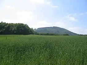 The Hochthürmerberg seen from Houverath | |
| Highest point | |
| Elevation | 499.9 m above sea level (NHN) (1,640 ft) [1] |
| Coordinates | 50°31′40″N 6°54′28″E |
| Geography | |
 Hochthürmerberg | |
| Parent range | Ahr Hills (Ahr Eifel) |
Location
The Hochthürmerberg is located within the Ahr Hills (Ahr Eifel) south of the village of Houverath in the county of Euskirchen ni North Rhine-Westphalia and northeast of the village of Kirchsahr in the county of Ahrweiler in Rhineland-Palatinate. The state border runs roughly along the 440-metre contour line over the southern flank of the hill. The Hochthürmerberg's neighbouring hill is the Hasenberg.
Summit and viewing points
At the summit are the remains of a circular rampart. The summit dome is wooded and offers no views at all. However, from a section of the Ahr-Fen Way, which is located between Kirchsahr and Krälingen, there are views of the Hohe Acht, the Michelsberg, the Nürburg and even the Scharteberg and Döhmberg. Near Krälingen there is a good view of the region of the Middle and Lower Ahr; nearby rise the hills of Krausberg, Neuenahrer Berg and the neighbouring Hasenberg.
