Hollygrove, New Orleans
Hollygrove is a neighborhood of the city of New Orleans, Louisiana, located in the city's 17th Ward. A subdistrict of the Uptown/Carrollton area, its boundaries as defined by the City Planning Commission are: Palmetto Street to the north, Cambronne, Edinburgh, Forshey, Fig and Leonidas Streets to the east, Earhart Boulevard to the south and the Jefferson Parish boundary to the west. Conrad playground, the Cuccia-Byrnes playground and Larry Gilbert baseball stadium are located in Hollygrove. The Hollygrove Market and Farm is also located in Hollygrove. Notable people, including rapper Lil Wayne, have grown up in the neighborhood.
Hollygrove
17th Ward | |
|---|---|
New Orleans Neighborhood | |
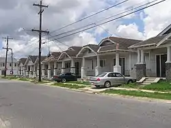 row houses on Leonidas Street | |
| Coordinates: 29°57′57″N 90°07′16″W | |
| Country | United States |
| State | Louisiana |
| City | New Orleans |
| Planning District | District 3, Uptown/Carrollton |
| Area | |
| • Total | 0.62 sq mi (1.6 km2) |
| • Land | 0.62 sq mi (1.6 km2) |
| • Water | 0.00 sq mi (0.0 km2) |
| Elevation | 0 ft (0 m) |
| Population (2010) | |
| • Total | 6,919 |
| • Density | 11,000/sq mi (4,300/km2) |
| Time zone | UTC-6 (CST) |
| • Summer (DST) | UTC-5 (CDT) |
| Area code(s) | 504 |
History
Hollygrove was once a piece of the McCarty plantation, grew out of the town of Carrollton, a suburb outside of New Orleans. Before the 1920s, when development began, Hollygrove was a low-lying swamp land, essentially untouched and unoccupied. Drainage systems installed in the 1920s allowed for housing to be built, although these systems never proved effective. In the 1960s, drainage methods were reworked to be more reliable, allowing for more housing to be developed. Even before effective drainage was implemented, Hollygrove grew drastically, the effects of which are still visible today. The Greater New Orleans Community Data Center that, pre-Katrina, nearly fifty percent of Hollygrove’s houses were built before 1949. Similarly, before Katrina, over half of the homes in Hollygrove were owner-occupied. When Hurricane Katrina breached the levees of New Orleans, Hollygrove began to flood, taking in water. Persevering, Hollygrove’s community has returned with great strength – the Louisiana State University survey on contractor fraud reported that Hollygrove/Gert Town’s recovery of residence was high; on a scale from 1 (lowest recovery of residence) to 11 (highest), Hollygrove and Gert Town were placed at a 9. The neighborhood is home to generations of families, creating a strong sense of place and community. Rebuilding Together is proud to partner with the Trinity Christian Community, based in Hollygrove, in order to build a relationship with the neighborhood and facilitate its growth.[1]
Geography
Hollygrove is located at 29°57′57″N 90°07′16″W [2] and has an elevation of 0 feet (0.0 m).[3] According to the United States Census Bureau, the district has a total area of 0.62 square miles (1.6 km2), 0.62 square miles (1.6 km2) of which is land and 0.00 square miles (0.0 km2) (0.0%) of which is water.
Boundaries
The Greater New Orleans Community Data Center defines the boundaries of Hollygrove as highway I-10 to the north, Carrollton Avenue to the east, South Claiborne Avenue to the south, and Monticello Avenue to the west.[4] The City Planning Commission defines the boundaries of Hollygrove as these streets: Palmetto Street, Cambronne Street, Edinburgh Street, Forshey Street, Fig Street Leonidas Street, South Claiborne Avenue and the Monticello Canal. The Neighborhood defines its boundaries as S. Carrolltonn, S. Claiborne, Monticello (@the canal, Orleans/Jefferson Parish line) and Airline Highway.[5][6][7] Earhart Blvd. runs through the neighborhood.
Crime
Since the 1970s Hollygrove has been associated with drug dealers and has been known to have a very high homicide rate. Shortly after Crack Cocaine hit the streets, NOPD waged war with drug dealers that dominated Hollygrove and the Gert Town area. By the 1980s and 1990s, gunfire was a constant fact of Hollygrove life.[8] The overall crime rate in Hollygrove is 136% higher than the national average. For every 100,000 people, there are 19.15 daily crimes that occur in Hollygrove. The number of total year over year crimes in New Orleans has increased by 12%.[9] In 2017 NOPD installed ten security surveillance cameras throughout the neighborhood to prevent crime. Residents say they feel a little safer after the new security cameras are installed.[10]
Demographics
As of the census of 2000, there were 6,919 people, 2,655 households, and 1,803 families residing in the neighborhood.[11] The population density was 11,160 /mi² (4,323 /km²). As of the census of 2010, there were 4,377 people, 1,761 households, and 1,118 families residing in the neighborhood.[11]
Notable people
- Lil Wayne, rapper[12]
- Johnny Adams, R&B singer
- Theryl DeClouet, member of Galactic
- Fiend, rapper
- Mack Maine, rapper
- Johnny St. Cyr jazz composer, banjo, guitarist
- Jason Mitchell, actor
- Partners-N-Crime, Rap duo
- Nesby Phips, producer, rapper and visual artist
Education
New Orleans Public Schools (NOPS) and the Recovery School District (RSD) operate public schools and handle charter schools.
Mary McLeod Bethune Elementary School, a school under the NOPS, is located in Hollygrove. In 2005 there was a proposal to close the school. At the time the school had a performance score of 101 on a scale of 250 and the state gave it a two star rating, which was considered positive.[13] In 2008, of the fourth grade students, about 4% of the fourth-grade students failed the LEAP tests. In the English test, 44% scored basic, 37% scored mastery, and 4% scored advanced. In 2009, no students failed the LEAP test. For that year, 7% scored basic, 79% scored mastery, and 14% scored advanced. In 2009 many art, drama, and music programs incorporate mathematics and reading lessons. During that year, according to principal Mary Haynes-Smith, most teachers at the school had at least 15 years of experience.[14] Jarvis DeBerry of The Times-Picayune said in 2010 that the school had a "status as one of the best schools in New Orleans and the metropolitan area."[15] In June 2010 NOPS gave the school an award for being a "High Performing/High Poverty School".[16]
As of 2011 the Benjamin Banneker School was scheduled to move into the former Dunbar Elementary School site in Hollygrove. There were plans for a $22.3 million school building there.[17]
See also
- New Orleans neighborhoods
References
- "Hollygrove - Rebuilding Together New Orleans". www.rtno.org.
- "US Gazetteer files: 2010, 2000, and 1990". United States Census Bureau. 2011-02-12. Retrieved 2011-04-23.
- "US Board on Geographic Names". United States Geological Survey. 2007-10-25. Retrieved 2008-01-31.
- Greater New Orleans Community Data Center. "Hollygrove Neighborhood". Retrieved 2011-01-31.
- "Hollygrove | Rebuilding Together New Orleans". www.rtno.org. Retrieved 2016-05-22.
- "<GNOCDC> Hollygrove Maps". www.datacenterresearch.org. Retrieved 2016-05-22.
- "Holly Grove, New Orleans, Louisiana Zip Code Boundary Map (LA)". www.zipmap.net. Retrieved 2016-05-22.
- "Hollygrove activists tout neighborhood's reduction in crime at Tulane forum – Uptown Messenger". uptownmessenger.com.
- areavibes. "Holly Grove, LA Crime Rates & Crime Map". www.areavibes.com.
- Gatto, Meg. "Hollygrove residents hope new cameras deter crime".
- "Hollygrove Neighborhood". Greater New Orleans Community Data Center. Retrieved 6 January 2012.
- Montoya, Maria C. and Keith Spera (music writer). "Lil Wayne goes back to school (story and video)." New Orleans Times Picayune. Saturday February 23, 2008. Retrieved on March 16, 2013.
- Schleifstein, Mark. "Reaction cool to planned school shuffle." The Times-Picayune. Monday May 2, 2005. Retrieved on March 30, 2013. "A prime example is the proposed closure of Mary M. Bethune Elementary in Hollygrove, which received a positive two-star rating from the state, with a school performance score of 101 on a scale of 250. When the accountability system was introduced in 1999, the goal was to get all schools to score 100 by the year 2009."
- Broach, Drew. "Mary McCleod Bethune Elementary." The Times-Picayune. April 30, 2009. Retrieved on March 30, 2013.
- DeBerry, Jarvis. "In a word, New Orleans' Bethune Elementary students are invincible: Jarvis DeBerry." The Times-Picayune. April 25, 2010. Retrieved on March 30, 2013.
- TEG. "NOPS Celebrates Bethune Elementary and Principal Mary Haynes-Smith." The Times-Picayune. Tuesday June 8, 2010. Retrieved on March 30, 2013.
- "KIPP on South Carrollton headed to Gentilly, Banneker to Hollygrove, RSD says." Uptown Messenger. November 15, 2011. Retrieved on April 1, 2013. "Likewise, the Banneker school is slated to move to the old Dunbar elementary site on Forshey Street just off Airline Highway in Hollygrove, where a $22.3 million building is planned, leaving its current site on Burdette as an opportunity campus as well."
External links
- Map of Hollygrove - Greater New Orleans Community Data Center
- Neighborhood snapshot - Greater New Orleans Community Data Center (2002-10-05)
- Bethune Elementary School
| Wikimedia Commons has media related to Hollygrove, New Orleans. |
Places adjacent to Hollygrove, New Orleans | ||||||||||
|---|---|---|---|---|---|---|---|---|---|---|
| ||||||||||