Homai railway station
Homai railway station is on the Southern Line of the Auckland railway network in New Zealand. It has an Island platform layout. A bus stop and a park and ride facility are located adjacent to the station.
Homai | |||||||||||
|---|---|---|---|---|---|---|---|---|---|---|---|
| Auckland Transport Urban rail | |||||||||||
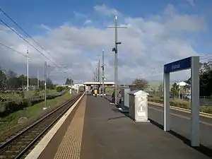 Looking south at Homai station in 2014 | |||||||||||
| Location | Homai | ||||||||||
| Coordinates | 37.0134°S 174.8748°E | ||||||||||
| Owned by | KiwiRail (track and platforms) Auckland Transport (buildings) | ||||||||||
| Line(s) | Southern Line | ||||||||||
| Platforms | Island platform | ||||||||||
| Tracks | Mainline (2) | ||||||||||
| Construction | |||||||||||
| Platform levels | 1 | ||||||||||
| Parking | Yes | ||||||||||
| Bicycle facilities | No | ||||||||||
| Other information | |||||||||||
| Station code | HOM | ||||||||||
| History | |||||||||||
| Opened | 15 August 1924[1] | ||||||||||
| Rebuilt | 2006 | ||||||||||
| Electrified | 25 kV AC | ||||||||||
| Passengers | |||||||||||
| 2011 | 1,707 passengers/weekday[2] | ||||||||||
| Services | |||||||||||
| |||||||||||
History
The North Island Main Trunk Line through South Auckland opened in 1875. However, Homai Station didn't open until 15 August 1924.[1] In line with other stations opened in Auckland suburbs at the time, it was partly financed by local developers.[3] In the case of Homai, John Dreadon donated £500 and land for the station and the bridge, which replaced a level crossing.[4] Three other landowners also contributed. As a result, it was decided to name the station using the Māori word for 'gift', homai,[5] rather than Browns Rd, as it was initially referred to.[6]
Daily boardings were measured as 338 in 2003. This figure had jumped to 936 by 2010.[7] The station was upgraded in 2006 with a modern shelter, platform lighting and a much longer platform installed.
Services
Transdev Auckland, on behalf of Auckland Transport, operates suburban services to Britomart, Papakura and Pukekohe via Homai. The typical weekday off-peak timetable is:[8]
- 3 tph to Britomart, via Penrose and Newmarket
- 3 tph to Papakura
Homai Station is served by bus routes 361 and 365.[9]
Access
There are three ways to access the platform. There is a ramp down from the Browns Road Overbridge to the south end of the platform. There is a pedestrian level crossing from the park and ride carpark (which is on Dalgety Drive) to the south end of the platform, and there is another pedestrian level crossing from McVilly Road to the north end of the platform.
See also
References
- Scoble, Juliet (2010). "Names & Opening & Closing Dates of Railway Stations" (PDF). Rail Heritage Trust of New Zealand. Retrieved 10 October 2019.
- Auckland Transport Board Meeting (20 November 2012) Agenda Item 10(i) "Rail Electrification Extension" Archived 14 December 2012 at the Wayback Machine p. 16
- "Three New Stations". Auckland Star. 4 May 1925. p. 8. Retrieved 26 April 2016.
- "Manurewa street names". www.aucklandlibraries.govt.nz. Retrieved 26 April 2016.
- "Local And General News". New Zealand Herald. 30 August 1922. p. 6. Retrieved 26 April 2016.
- Rail Heritage Trust of New Zealand
- "Surveyed Boardings per Station 2003 to 2010". Auckland Transport. Retrieved 21 April 2012.
- "Southern Line timetable" (PDF). Auckland Transport. Retrieved 17 November 2019.
- "Southern Guide" (PDF). Auckland Transport. Retrieved 20 February 2020.