Hoogezand-Sappemeer
Hoogezand-Sappemeer (Dutch pronunciation: [ɦoːɣəˌzɑnt sɑpəˈmeːr] (![]() listen)) is a former municipality in the northeastern Netherlands. It was the third most-populous municipality in the province of Groningen, after the city of Groningen and Oldambt, formed in 1949 by the merger of the former municipalities Hoogezand, well known for its ship building industry, and Sappemeer. On January 1, 2018, Hoogezand-Sappemeer merged with Slochteren and Menterwolde, forming the municipality Midden-Groningen.
listen)) is a former municipality in the northeastern Netherlands. It was the third most-populous municipality in the province of Groningen, after the city of Groningen and Oldambt, formed in 1949 by the merger of the former municipalities Hoogezand, well known for its ship building industry, and Sappemeer. On January 1, 2018, Hoogezand-Sappemeer merged with Slochteren and Menterwolde, forming the municipality Midden-Groningen.
Hoogezand-Sappemeer | |
|---|---|
Former municipality | |
.svg.png.webp) Location in Groningen | |
| Coordinates: 53°9′N 6°45′E | |
| Country | Netherlands |
| Province | Groningen |
| Municipality | Midden-Groningen |
| Established | 1949 |
| Ceased to exist | 2017 |
| Area | |
| • Total | 72.99 km2 (28.18 sq mi) |
| • Land | 66.71 km2 (25.76 sq mi) |
| • Water | 6.28 km2 (2.42 sq mi) |
| Elevation | 2 m (7 ft) |
| Time zone | UTC+1 (CET) |
| • Summer (DST) | UTC+2 (CEST) |
| Postcode | 9600–9614, 9630–9633 |
| Area code | 0598 |
Geography
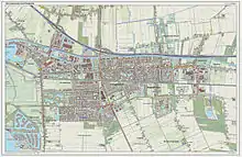
Population centres in the municipality are:
- Achterdiep
- Borgercompagnie
- Borgweg
- Foxham
- Foxhol
- Foxholsterbosch
- Hoogezand
- Jagerswijk
- Kalkwijk
- Kiel-Windeweer
- Kleinemeer
- Kropswolde
- Lula
- Martenshoek
- Meerwijck
- Nieuwe Compagnie
- Sappemeer
- Tripscompagnie
- Waterhuizen
- Westerbroek
- Wolfsbarge
Transportation
The A7 motorway (European Highway E 22, Amsterdam-Groningen-Germany) crosses the municipality. There is also a railway line providing service to Groningen and Nieuweschans/Leer(Germany). Trains serve four stations in the municipality, Kropswolde, Martenshoek, Hoogezand-Sappemeer, and Sappemeer Oost. Since 2007, trains will stop 4 times an hour.
References
- "Kerncijfers wijken en buurten 2020" [Key figures for neighbourhoods 2020]. StatLine (in Dutch). CBS. 24 July 2020. Retrieved 19 September 2020.
- "Postcodetool for 9603AE". Actueel Hoogtebestand Nederland (in Dutch). Het Waterschapshuis. Archived from the original on 21 September 2013. Retrieved 23 January 2014.
External links
- Official website
 Media related to Hoogezand-Sappemeer at Wikimedia Commons
Places adjacent to Hoogezand-Sappemeer | ||||||||||
|---|---|---|---|---|---|---|---|---|---|---|
| ||||||||||