Tynaarlo
Tynaarlo (pronounced [tiˈnaːrloː] (![]() listen)) is a municipality in the northeastern Netherlands. Though located in the province of Drenthe, many of its communities serve as suburbs of the neighbouring city of Groningen, capital of the province of the same name.
listen)) is a municipality in the northeastern Netherlands. Though located in the province of Drenthe, many of its communities serve as suburbs of the neighbouring city of Groningen, capital of the province of the same name.
Tynaarlo | |
|---|---|
 Dolmen D6 near Tynaarlo | |
 Flag Coat of arms | |
.svg.png.webp) Location in Drenthe | |
| Coordinates: 53°5′N 6°35′E | |
| Country | Netherlands |
| Province | Drenthe |
| Established | 1 January 1998[1] |
| Renamed | 1 January 2000[2] |
| Government | |
| • Body | Municipal council |
| • Mayor | Marcel Thijsen |
| Area | |
| • Total | 147.70 km2 (57.03 sq mi) |
| • Land | 143.00 km2 (55.21 sq mi) |
| • Water | 4.70 km2 (1.81 sq mi) |
| Elevation | 6 m (20 ft) |
| Population (January 2019)[6] | |
| • Total | 33,698 |
| • Density | 236/km2 (610/sq mi) |
| Time zone | UTC+1 (CET) |
| • Summer (DST) | UTC+2 (CEST) |
| Postcode | Parts of 9000 range |
| Area code | 050, 0592, 0598 |
| Website | www |
Population centres
Topography

Town of Tynaarlo

The town of Tynaarlo is a part of the municipality and lies about 9 km (5.6 mi) north of Assen. It is situated between the three largest villages of the municipality: Zuidlaren, Eelde and Vries. Tynaarlo is located close to the motorway A28, which is a connection to the south and the west of the country.
In 2001, the town of Tynaarlo had 1009 inhabitants. The built-up area of the town was 0.29 km2 (0.11 sq mi), and contained 427 residences.[7] The statistical district "Tynaarlo", which also can include the surrounding countryside, has a population of around 1920.[8]
Notable people
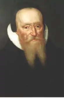
- Menso Alting (1541 in Eelde – 1612) a Dutch Reformed preacher and reformer
- Lodewijk van Heiden (1772 in Zuidlaren – 1850) a Dutch Admiral
Sport
- Jaap Helder (1907 in Paterswolde – 1998) a sailor, participated in the 1960 Summer Olympics
- Roelof Koops (1909 in Zuidlaren – 2008) a Dutch speed skater who competed in the 1936 Winter Olympics
- Paul Matthijs (born 1976 in Paterswolde) a Dutch footballer with over 300 club caps
- Jos Hooiveld (born 1983 in Zeijen) a Dutch footballer with over 300 club caps
- Willemijn Bos (born 1988 in Eelde) is a Dutch field hockey defender, team silver medallist at the 2016 Summer Olympics
Gallery
_Vries_Dr_NL.jpg.webp)
References
- "Gemeentelijke indeling op 1 januari 1998" [Municipal divisions on 1 January 1998]. cbs.nl (in Dutch). CBS. Retrieved 11 October 2013.
- "Gemeentelijke indeling op 1 januari 2000" [Municipal divisions on 1 January 2000]. cbs.nl (in Dutch). CBS. Retrieved 11 October 2013.
- "Dhr. P. Adema" [Mr. P. Adema] (in Dutch). Gemeente Tynaarlo. Archived from the original on 11 October 2013. Retrieved 11 October 2013.
- "Kerncijfers wijken en buurten 2020" [Key figures for neighbourhoods 2020]. StatLine (in Dutch). CBS. 24 July 2020. Retrieved 19 September 2020.
- "Postcodetool for 9481AW". Actueel Hoogtebestand Nederland (in Dutch). Het Waterschapshuis. Retrieved 11 October 2013.
- "Bevolkingsontwikkeling; regio per maand" [Population growth; regions per month]. CBS Statline (in Dutch). CBS. 1 January 2019. Retrieved 1 January 2019.
- Statistics Netherlands (CBS), Bevolkingskernen in Nederland 2001. (Statistics are for the continuous built-up area).
- Statistics Netherlands (CBS), Statline: Kerncijfers wijken en buurten 2003-2005. As of 1 January 2005.
External links
| Wikivoyage has a travel guide for Tynaarlo. |
| Wikimedia Commons has media related to Tynaarlo. |
Places adjacent to Tynaarlo | ||||||||||
|---|---|---|---|---|---|---|---|---|---|---|
| ||||||||||
Municipalities of Drenthe | ||
|---|---|---|
 | ||
| ||