Howey-in-the-Hills, Florida
Howey-In-The-Hills is a town in Lake County, Florida, United States. The population was 1,098 at the 2010 census[2] and an estimated 1,175 in 2018.[6] It is part of the Orlando–Kissimmee–Sanford Metropolitan Statistical Area.
Howey-in-the-Hills, Florida | |
|---|---|
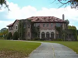 Howey Mansion, original home of the town's founder | |
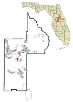 Location in Lake County and the state of Florida | |
| Coordinates: 28°42′58″N 81°46′28″W | |
| Country | |
| State | |
| County | |
| Area | |
| • Total | 3.67 sq mi (9.51 km2) |
| • Land | 3.16 sq mi (8.19 km2) |
| • Water | 0.51 sq mi (1.32 km2) |
| Elevation | 121 ft (37 m) |
| Population | |
| • Total | 1,098 |
| • Estimate (2019)[3] | 1,181 |
| • Density | 373.62/sq mi (144.27/km2) |
| Time zone | UTC-5 (Eastern (EST)) |
| • Summer (DST) | UTC-4 (EDT) |
| ZIP code | 34737 |
| Area code(s) | 352 |
| FIPS code | 12-32775[4] |
| GNIS feature ID | 0295002[5] |
| Website | www |
History
Howey-in-the-Hills was founded by William John Howey, a citrus grower and real-estate developer. On May 8, 1925, Howey-in-the-Hills was incorporated as the Town of Howey. In 1927 the name was officially changed to Howey-in-the-Hills, to reflect the location of the town in an area of rolling hills.
The first citrus juice plant in Florida was built in Howey-in-the-Hills by William John Howey in 1921.
Geography
Howey-in-the-Hills is located in central Lake County at 28°42′58″N 81°46′28″W (28.716221, -81.774540).[7] It sits on the west shore of Little Lake Harris, an arm of Lake Harris. The town is bordered to the northwest by the unincorporated community of Yalaha.
Florida State Road 19 passes through the town as Palm Avenue. It leads north across Little Lake Harris and leads 8 miles (13 km) to Tavares, the Lake county seat. To the south SR 19 leads 13 miles (21 km) to Groveland.
According to the United States Census Bureau, Howey-in-the-Hills has a total area of 3.7 square miles (9.5 km2), of which 3.2 square miles (8.2 km2) are land and 0.50 square miles (1.3 km2), or 13.9%, are water.[8]
Demographics
| Historical population | |||
|---|---|---|---|
| Census | Pop. | %± | |
| 1930 | 338 | — | |
| 1940 | 203 | −39.9% | |
| 1950 | 188 | −7.4% | |
| 1960 | 402 | 113.8% | |
| 1970 | 466 | 15.9% | |
| 1980 | 626 | 34.3% | |
| 1990 | 724 | 15.7% | |
| 2000 | 956 | 32.0% | |
| 2010 | 1,098 | 14.9% | |
| 2019 (est.) | 1,181 | [3] | 7.6% |
| U.S. Decennial Census[9] | |||
As of the census[4] of 2000, there were 956 people, 385 households, and 291 families residing in the town. The population density was 540.6 people per square mile (208.5/km2). There were 450 housing units at an average density of 254.5 per square mile (98.2/km2). The racial makeup of the town was 96.97% White, 0.52% African American, 0.21% Native American, 0.73% Asian, 0.21% from other races, and 1.36% from two or more races. Hispanic or Latino of any race were 2.20% of the population.
There were 385 households, out of which 27.8% had children under the age of 18 living with them, 64.9% were married couples living together, 7.8% had a female householder with no husband present, and 24.4% were non-families. 18.4% of all households were made up of individuals, and 8.3% had someone living alone who was 65 years of age or older. The average household size was 2.48 and the average family size was 2.80.
In the town, the population was spread out, with 20.7% under the age of 18, 4.5% from 18 to 24, 24.2% from 25 to 44, 29.0% from 45 to 64, and 21.7% who were 65 years of age or older. The median age was 45 years. For every 100 females, there were 98.8 males. For every 100 females age 18 and over, there were 99.5 males.
The median income for a household in the town was $49,327, and the median income for a family was $51,458. Males had a median income of $39,773 versus $27,727 for females. The per capita income for the town was $23,273. About 3.4% of families and 5.7% of the population were below the poverty line, including 9.5% of those under age 18 and 2.2% of those age 65 or over.
References
- "2019 U.S. Gazetteer Files". United States Census Bureau. Retrieved July 2, 2020.
- "Profile of General Population and Housing Characteristics: 2010 Census Summary File 1 (DP-1), Howey-in-the-Hills town, Florida". American FactFinder. U.S. Census Bureau. Archived from the original on February 13, 2020. Retrieved November 12, 2019.
- "Population and Housing Unit Estimates". United States Census Bureau. May 24, 2020. Retrieved May 27, 2020.
- "U.S. Census website". United States Census Bureau. Retrieved 2008-01-31.
- "US Board on Geographic Names". United States Geological Survey. 2007-10-25. Retrieved 2008-01-31.
- "Annual Estimates of the Resident Population for Incorporated Places: April 1, 2010 to July 1, 2018: Incorporated Places: Florida". Archived from the original on February 13, 2020. Retrieved November 12, 2019.
- "US Gazetteer files: 2010, 2000, and 1990". United States Census Bureau. 2011-02-12. Retrieved 2011-04-23.
- "U.S. Gazetteer Files: 2019: Places: Florida". U.S. Census Bureau Geography Division. Retrieved November 12, 2019.
- "Census of Population and Housing". Census.gov. Retrieved June 4, 2015.
External links
Municipalities and communities of Lake County, Florida, United States | ||
|---|---|---|
| Cities | 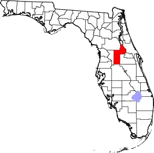 | |
| Towns | ||
| CDPs | ||
| Unincorporated communities | ||
| Footnotes | ‡This populated place also has portions in an adjacent county or counties | |
| ||
| Authority control |
|---|