Hrádek (Rokycany District)
Hrádek (German: Hradek) is a town in the Plzeň Region of the Czech Republic, 5 km southeast of Rokycany. It has about 2,800 inhabitants. It lies 440 m above sea level in the valley of Klabava River which is also known as Padrťský potok. North of Hrádek, large forested massif of Žďár (629 m above sea level) with its lateral elevation of Hrádecký vrch (549 m above sea level) delineates northern border of the Klabava valley while in the south relatively mild slopes form large plateau where most of Hrádek's built-up area lies. The most prominent elevation in the southern section of the valley is Svatý Vojtěch hill (513 m above sea level). Hrádek together with Rokycany and Kamenný Újezd belongs to the contiguous urban area along the Klabava valley. Main artery of this urban concentration being road from Rokycany to Mirošov that runs along Hrádek's western periphery. Another road connecting Rokycany and Strašice via Dobřív runs north of Hrádek.
Hrádek | |
|---|---|
Town | |
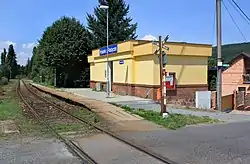 Train station | |
 Flag  Coat of arms | |
 Hrádek Location in the Czech Republic | |
| Coordinates: 49°42′47″N 13°39′17″E | |
| Country | |
| Region | Plzeň |
| District | Rokycany |
| First mentioned | 1325 |
| Government | |
| • Mayor | Marcela Sobotková |
| Area | |
| • Total | 6.05 km2 (2.34 sq mi) |
| Elevation | 440 m (1,440 ft) |
| Population (2020-01-01[1]) | |
| • Total | 2,850 |
| • Density | 470/km2 (1,200/sq mi) |
| Time zone | UTC+1 (CET) |
| • Summer (DST) | UTC+2 (CEST) |
| Postal code | 338 42 |
| Website | www |
Demography
As to ethnicity, Hrádek was traditionally a Czech settlement. In 1890 population of Hrádek was 448, village of Nová Huť had population of 215 then. In 20th century population steadily grew. After World War II massive housing project of completely new town of Hrádek was started and population reached more than 3,000. Since reaching its peak in 1980 town's population has been dropping slightly. As of Jan. 1st 2007 Hrádek had 2,999 inhabitants.[2][3][4]
|
|
History
There are two historical village communities in the territory of what is now Hrádek. Village of Hrádek was mentioned as early as 1325. The king John of Bohemia donated Hrádek to Petr of Rosenberg then. Village of Nová Huť was located ca. 1 km to the east of Hrádek. Since Middle Ages the Klabava Valley region specialized in iron ore mining and iron production. This industrial aspect was further strengthened in the 20th century when both communities (Hrádek and Nová Huť) formed functionally one settlement with their economy centered around the Hrádecké železárny steelworks. Later both villages merged into one under name of Hrádek.
After World War II, local steelworks have expanded filling most of the area along the Klabava River. These investments were accompanied by massive residential construction that completely transformed Hrádek. New housing project grew in area between old Hrádek and Nová Huť villages covering the plateau south of Klabava river. Architecture of earlier stages of this new tenement houses district was inspired by Socialist realism. Main axis of new Hrádek is a wide avenue (1.máje Street) leading from Nová Huť to the southeast where it ends in central square (9.května Square) with community center, department store and other public facilities. Rapid population growth followed and Hrádek acquired urban character. In 1975 Hrádek was officially declared a town. After 1989 Hrádecké železárny went through uneasy transformation which resulted in rising unemployment but in 1998 Borgers CS new factory opened[5] in area between the town and the steelworks.
References
- "Population of Municipalities – 1 January 2020". Czech Statistical Office. 2020-04-30.
- Vývoj počtu obyvatel správních obvodů a měst
- 1301-07, Počet obyvatel v obcích České republiky , obsah | ČSÚ
- http://www.czso.cz/xp/edicniplan.nsf/t/E4002BDBFB/$File/13-322603b01.xls Archived 2011-06-08 at the Wayback Machine
- "Archived copy". Archived from the original on 2007-03-29. Retrieved 2008-01-23.CS1 maint: archived copy as title (link)
External links
| Wikimedia Commons has media related to Hrádek (Rokycany District). |
| Authority control |
|
|---|