Hughes Bluff
Hughes Bluff is a conspicuous rock and ice bluff, 310 metres (1,020 ft) high, along the south side of David Glacier, 6 nautical miles (11 km) west of Cape Reynolds, in Victoria Land, Antarctica. It was mapped by the United States Geological Survey from surveys and U.S. Navy tricamera aerial photography, 1957–62, and was named by the Advisory Committee on Antarctic Names for Garrett A. Hughes, a United States Antarctic Research Program researcher (cosmic radiation) at McMurdo Station in 1966.[1]
| Hughes Bluff | |
|---|---|
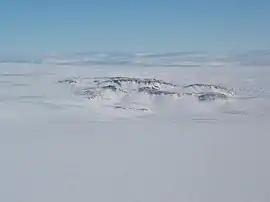 Hughes Bluff, as viewed from the south east. David Glacier is in the far distance, flowing from left to right on this photo. | |
| Highest point | |
| Elevation | 310 m (1,020 ft) |
| Coordinates | 75°24′S 162°12′E |
| Geography | |
| Location | Victoria Land, Antarctica |
References
- "Hughes Bluff". Geographic Names Information System. United States Geological Survey. Retrieved 2012-07-02.
![]() This article incorporates public domain material from the United States Geological Survey document: "Hughes Bluff". (content from the Geographic Names Information System)
This article incorporates public domain material from the United States Geological Survey document: "Hughes Bluff". (content from the Geographic Names Information System)
This article is issued from Wikipedia. The text is licensed under Creative Commons - Attribution - Sharealike. Additional terms may apply for the media files.