Huish, Wiltshire
Huish is a small village and civil parish in Wiltshire, England, 2 miles (3.2 km) northwest of Pewsey and 4 miles (6.4 km) southwest of Marlborough. It is on the south-facing edge of the Marlborough Downs, where the downs adjoin the Vale of Pewsey.
| Huish | |
|---|---|
Nov2006.jpg.webp) St. Nicholas's Church, Huish | |
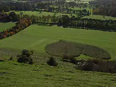 The heart-shaped copse | |
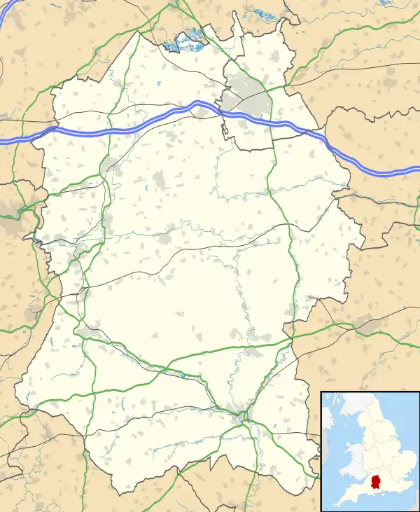 Huish Location within Wiltshire | |
| Population | 43 (in 2011)[1] |
| OS grid reference | SU145635 |
| Civil parish |
|
| Unitary authority | |
| Ceremonial county | |
| Region | |
| Country | England |
| Sovereign state | United Kingdom |
| Post town | Marlborough |
| Postcode district | SN8 |
| Dialling code | 01672 |
| Police | Wiltshire |
| Fire | Dorset and Wiltshire |
| Ambulance | South Western |
| UK Parliament | |
| Website | www |
History
A small settlement of 11 households was recorded in the Domesday Book of 1086, when the lord of the manor was Richard Sturmy[2] or Esturmy.[3] The population of the parish remained low, reaching around 130 at its height between 1831 and 1881, then declining to 30 at the 1971 census.[1]
The church and Manor Farm lie some 250 metres north of the present village, along a lane which continues (now as a track) some 1.5 km northwest to the site of the deserted village of Shaw, now in the parishes of Alton and West Overton.[4] By the 18th century there was a hamlet on Huish Hill, straddling the boundary with Wilcot, some 900 metres north of Oare at grid reference SU157641; this hamlet began to be abandoned in the 1920s.[3]
In 1803, land to the west of Oare village which belonged to the lords of Huish was deemed part of Huish parish. Thus the southeast boundary of Huish extends close to Oare, and Oare school (now Oare Church of England Primary School) is within Huish parish.[3]
Cold Blow, a thatched house on the outskirts of Oare, was built in 1921–22 to designs of Clough Williams-Ellis.[5]
A heart-shaped tree plantation was created in 1999, below Huish Hill in the southeast of the parish, near Oare.[6] This is a geoglyph, but not a hill figure like the many surrounding "white horses" such as the Marlborough White Horse.
Local government
Although a civil parish in its own right, Huish elects a joint parish council with the larger neighbouring parish of Wilcot. The full name of the council is 'Wilcot and Huish (with Oare)'.[7]
Huish falls within the area of the Wiltshire Council unitary authority, which is responsible for all significant local government functions, and is represented there by Paul Oatway who succeeded Brigadier Robert Hall in 2013.
Parish church
A church was recorded at Huish in 1291. The Church of England parish church of Saint Nicholas was rebuilt in 1785, near the foundations of the 13th-century church but in a smaller size; it was again rebuilt in 1878–9.[8][9]
In 1924 the benefices of Huish and Oare were united, with the parsonage house to be at Huish.[10] Wilcot was added in 1962.[11] In 1972 the parishes of Huish and Oare were united, and at the same time the benefice was extended by adding Woodborough with Manningford Bohune and Beechingstoke.[12] Today the parish of Huish and Oare is part of the Vale of Pewsey team of churches.[13]
The former rectory, a three-bay house in brick of c. 1812, is now a private house.[14]
References
- "Wiltshire Community History – Census". Wiltshire Council. Retrieved 15 February 2015. Note ONS raw data (as opposed to this County Council figure) is for an area 'too small to publish all data for reasons of confidentiality of living people' its parish data being combined with much of Wilcot into output area E00162557 so more demographic statistics will become available in a few decades from 2011
- Huish in the Domesday Book
- Baggs, A.P.; Crowley, D.A.; Pugh, Ralph B.; Stevenson, Janet H.; Tomlinson, Margaret (1975). Crittall, Elizabeth (ed.). "Victoria County History: Wiltshire: Vol 10 pp77-82 – Parishes: Huish". British History Online. University of London. Retrieved 3 September 2017.
- "Victoria County History – Wiltshire – Vol 10 pp8-13 – Parishes: Alton Barnes". British History Online. University of London. 1975. Retrieved 8 October 2017.
- Historic England. "Cold Blow (1192603)". National Heritage List for England. Retrieved 11 September 2017.
- Jones, Sarah (1 February 2010). "Heart shaped wood mystery at Oare". BBC News: Wiltshire. Retrieved 24 August 2017.
- "Standing Orders" (PDF). Wilcot and Huish (with Oare) Parish Council. Retrieved 15 February 2015.
- Baggs, A.P.; Crowley, D.A.; Pugh, Ralph B.; Stevenson, Janet H.; Tomlinson, Margaret (1975). Crittall, Elizabeth (ed.). "Victoria County History: Wiltshire: Vol 10 pp77-82 = Parishes:Huish". British History Online. University of London. Retrieved 29 August 2017.
- Historic England. "Church of St. Nicholas (1035682)". National Heritage List for England. Retrieved 29 August 2017.
- "No. 32910". The London Gazette. 22 February 1924. pp. 1553–1554.
- "No. 42864". The London Gazette. 21 December 1962. p. 9981.
- "No. 45614". The London Gazette. 3 March 1972. p. 2705.
- "Huish – St Nicholas". Vale of Pewsey Team. Retrieved 29 August 2017.
- Historic England. "Old Rectory (1035683)". National Heritage List for England. Retrieved 29 August 2017.
Further reading
- Chandler, John (2003). Devizes and Central Wiltshire. East Knoyle: Hobnob Press. pp. 101–104. ISBN 0-946418-16-0.
External links
![]() Media related to Huish, Wiltshire at Wikimedia Commons
Media related to Huish, Wiltshire at Wikimedia Commons
- "Wiltshire Community History - Huish". Wiltshire Council. Retrieved 15 February 2015.
- "Wilcot and Huish with Oare parish website". Retrieved 28 February 2014.