Humber River (Newfoundland and Labrador)
The Humber River is a river on Newfoundland in the Canadian province of Newfoundland and Labrador. It is approximately 120 kilometres long; it flows through the Long Range Mountains, southeast then southwest, through Deer Lake, to the Bay of Islands at Corner Brook. It begins near the town of Hampden. Taylor's Brook, Aidies Stream and Dead Water Brook run into the upper Humber. The Humber is one of Newfoundland's longest rivers.
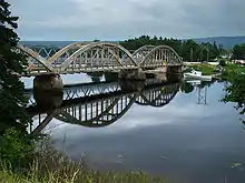
Nicholsville Bridge over the Humber
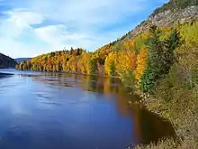
Autumn on the Humber
James Cook first charted the Humber in the summer of 1767.[1] It was named for its English counterpart the Humber (estuary).[2]
The Humber is rich in Atlantic Salmon, and was from the 1800s used as a waterway for European trappers and loggers.[3] It is one of the world's best recreational salmon fishing rivers.[4]
References
- Fast Facts & History "Archived copy". Archived from the original on 2014-10-17. Retrieved 2014-10-12.CS1 maint: archived copy as title (link), accessed 6 May 2016
- Humber River , accessed 6 May 2016
- Humber River., accessed 6 May 2016
- Humber Valley , accessed 6 May 2016
This article is issued from Wikipedia. The text is licensed under Creative Commons - Attribution - Sharealike. Additional terms may apply for the media files.
