Hurricane Andres (1979)
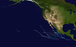
Hurricane Andres was the only landfalling hurricane during the 1979 Pacific hurricane season.[1] The deadliest Pacific hurricane, the first named storm, and first hurricane of the season, it formed as a tropical depression on May 31. The next day, the cyclone intensified into Tropical Storm Andres. In early June, it became a hurricane, and approached the Mexican coast as a large Category 2 hurricane. The hurricane disintegrated rapidly as it approached the coast, and eventually came ashore as a minimal hurricane on June 4. The cyclone dissipated shortly thereafter.
| Category 2 hurricane (SSHWS/NWS) | |
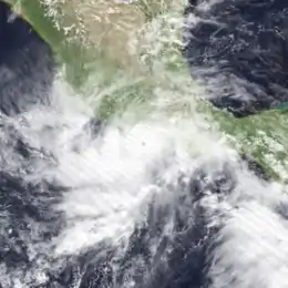
 Hurricane Andres near peak intensity off the Mexican coast on June 3 | |
| Formed | May 31, 1979 |
|---|---|
| Dissipated | June 4, 1979 |
| Highest winds | 1-minute sustained: 100 mph (155 km/h) |
| Lowest pressure | 992 mbar (hPa); 29.29 inHg |
| Fatalities | 2 total |
| Damage | Minimal |
| Areas affected | Mexico |
| Part of the 1979 Pacific hurricane season | |
Torrential rainfall triggered widespread flooding which inundated homes and floated cars left on streets. High winds also downed power lines, leaving many residents without electricity. Offshore, two fishermen were killed by the storm after their boat capsized amidst rough seas.
Meteorological history

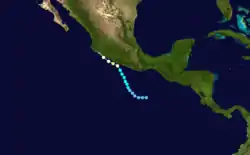
The origins of Andres were from a tropical disturbance about 345 mi (555 km) south of the Gulf of Tehuantepec on May 31. By 1800 UTC, an atmospheric circulation had developed, and the system was classified as a tropical depression. Initially, the depression moved westward at 7 mph (11 km/h), only to begin a steady movement to the north-northwest. Late on June 1, a ship reported winds of 30 mph (48 km/h) and 86 °F (30 °C) sea surface temperatures just west of the center of circulation. Based on this, the Eastern Pacific Hurricane Center upgraded the cyclone into Tropical Storm Andres on 0600 UTC on June 2.[2]
Andres gradually intensified as it tracked toward the Mexican coast; by 0000 UTC the next day winds had increased to 65 mph (105 km/h). Later that day, a ship named Atigun Pass reported winds of 70 mph (110 km/h) to 75 mph (120 km/h), very heavy rains, high seas, and a minimum pressure of 992 mbar (992 hPa; 29.3 inHg). On 1800 UTC on June 3, Andres intensified into a hurricane.[2]
Andres turned to the west-northwest and continued to intensify, developing a very small eye in the center. At 2300 UTC on June 3, a ship named Texaco Georgia reported winds of 90 mph (140 km/h) and 30 ft (9.1 m) waves. The ship also reported the center of the hurricane as a violent circular squall area, with a radius of 21 mi (34 km). By 0000 UTC on June 4, Andres reached its peak intensity of 100 mph (160 km/h) and a minimum pressure of 992 mbar (hPa; 29.29 inHg). Shortly thereafter, the same ship, now located only 7 mi (11 km) to the east of Andres, reported southerly 90 mph (140 km/h) winds and heavy rains over 81 °F (27 °C) waters. The hurricane weakened subsequently, and by 1200 UTC on June 4, the winds had decreased to an intensity of 75 mph (120 km/h). About an hour later, Andres made landfall southeast of Manzanillo.[2] Initial reports indicated that the storm made landfall with winds of 60 mph (95 km/h);[3] however, according to the Eastern Pacific Hurricane Database, the storm crossed the shore with winds of 75 mph (120 km/h). Andres weakened rapidly after moving ashore, and the final advisory was issued late on June 4, a mere 10 mi (16 km) inland.[2]
Preparations and impact
In preparation of Hurricane Andres, many airlines and airports canceled flights in and out of Acapulco. Hurricane warnings and hurricane watches were issued in the portion of southwestern Mexico. One resident in the city described the storms as "the wind was so strong, I couldn't leave my front steps. Cars are floating down the streets and some living rooms are ankle deep in water".[4] Acapulco's airport closed down when Andres struck land, but reopened a few days later.[3] The hurricane also brought gale-force winds to Acapulco, which knocked down power lines, and left hundreds without electricity.[5] Hurricane Andres sunk a luxury yacht, killing two passengers.[4] Because the area the storm struck was sparsely populated,[6] there were no reports major damage or injuries. Andres brought torrential rains to the coastal area of Michoacán;[3] some flooding was reported.[7]
See also
| Wikimedia Commons has media related to Hurricane Andres (1979). |
References
- Blake, Eric S; Gibney, Ethan J; Brown, Daniel P; Mainelli, Michelle; Franklin, James L; Kimberlain, Todd B; Hammer, Gregory R (2009). Tropical Cyclones of the Eastern North Pacific Basin, 1949-2006 (PDF). Archived from the original on July 28, 2013. Retrieved June 14, 2013.
- Gunther, Emil B. (May 1980). "Eastern North Pacific Tropical Cyclones of 1979". Monthly Weather Review. 108 (8): 631–642. doi:10.1175/1520-0493(1980)108<061:ENPTCO>2.0.CO;2.
- Associated Press (1979-06-05). "Season's first 'cane hits land". The Miami News. p. 41. Retrieved 2012-02-18.
- United Press International (1979-06-05). "Hurricane Andrew Hits". The Bryan Times. p. 2. Retrieved 2012-02-18.
- Staff Writer (1979-06-05). "Hurricane Rips Mexico". Reading Eagle. p. 21. Retrieved 2012-02-18.
- "Season's First Hurricane off Mexico in Pacific". Miami News. 1979-06-04. Retrieved 2012-02-21.
- "Hurricane, Quake hits Mexico". Kingman Daily Miner. 1979-06-04. Retrieved 2012-02-21.
